
| Birth | : | 14 Jan 1930 Antelope County, Nebraska, USA |
| Death | : | 23 Dec 1999 Central City, Merrick County, Nebraska, USA |
| Burial | : | Union Hill Friends Church Cemetery, Red Brush, Surry County, USA |
| Coordinate | : | 36.4714410, -80.6956890 |
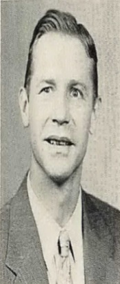
| Description | : | Samuel W. Escritt, 69, Central City, died Thursday at the hospital there. Services were held Tuesday from the Livingston-Sondermann Funeral Home with the Rev. Jerry Quandt officiating. Burial was at the Oakdale Cemetery, Oakdale, Neb. He was born Jan. 15,1930, in Antelope Co., Nebraska to William and Edith (Harbaugh) Escritt. Raised on the family farm near Neligh, he attended a country school near the farm, three years of high school at Neligh and graduated from Oakdale High School in 1947. While attending Nebraska Christian College he worked in Norfolk and did supply... Read More |
frequently asked questions (FAQ):
-
Where is Samuel Warren Escritt's memorial?
Samuel Warren Escritt's memorial is located at: Union Hill Friends Church Cemetery, Red Brush, Surry County, USA.
-
When did Samuel Warren Escritt death?
Samuel Warren Escritt death on 23 Dec 1999 in Central City, Merrick County, Nebraska, USA
-
Where are the coordinates of the Samuel Warren Escritt's memorial?
Latitude: 36.4714410
Longitude: -80.6956890
Family Members:
Parent

Spouse
Siblings
Flowers:


Nearby Cemetories:
1. Union Hill Friends Church Cemetery
Red Brush, Surry County, USA
Coordinate: 36.4714410, -80.6956890
2. Community Baptist Church Cemetery
Red Brush, Surry County, USA
Coordinate: 36.4713593, -80.7171097
3. Mosley Family Cemetery
Mount Airy, Surry County, USA
Coordinate: 36.4670770, -80.6681230
4. Tucker Cemetery
Pine Ridge, Surry County, USA
Coordinate: 36.4908889, -80.7153056
5. Tucker Cemetery
Mount Airy, Surry County, USA
Coordinate: 36.4908905, -80.7153091
6. Laurel Springs Primitive Baptist Church Cemetery
Pine Ridge, Surry County, USA
Coordinate: 36.4821930, -80.7263031
7. Dunbar Cemetery
Mount Airy, Surry County, USA
Coordinate: 36.4690010, -80.6567720
8. Antioch Baptist Church Cemetery
Toast, Surry County, USA
Coordinate: 36.5038872, -80.6841660
9. Pine Ridge Baptist Church Cemetery
Pine Ridge, Surry County, USA
Coordinate: 36.4995842, -80.7190552
10. Westside Baptist Church Cemetery
Toast, Surry County, USA
Coordinate: 36.4859720, -80.6574720
11. Blues Grove Baptist Church Cemetery
Red Brush, Surry County, USA
Coordinate: 36.4382210, -80.7058334
12. Surry County Veterans Cemetery
Toast, Surry County, USA
Coordinate: 36.5052800, -80.6835300
13. Semper Fi Cemetery
Pine Ridge, Surry County, USA
Coordinate: 36.5010540, -80.7216920
14. Johnson Family Cemetery
Mount Airy, Surry County, USA
Coordinate: 36.5037500, -80.6698330
15. Masadona Cemetery
Dobson, Surry County, USA
Coordinate: 36.4321940, -80.6973270
16. Creed Family Cemetery
Mount Airy, Surry County, USA
Coordinate: 36.4905280, -80.6525830
17. Old Fisher River Church Cemetery
Dobson, Surry County, USA
Coordinate: 36.4304420, -80.6992580
18. Whitlock Family Cemetery
Mount Airy, Surry County, USA
Coordinate: 36.4813056, -80.6422222
19. Genesis Full Gospel Church Cemetery
Toast, Surry County, USA
Coordinate: 36.5120010, -80.6711960
20. Oak Grove Baptist Church Cemetery
Oak Grove (Bottom), Surry County, USA
Coordinate: 36.4788770, -80.7540890
21. Gordon Cemetery
Mount Airy, Surry County, USA
Coordinate: 36.4234440, -80.6966390
22. Copeland Home Graveyard
Dobson, Surry County, USA
Coordinate: 36.4223490, -80.7089350
23. McCraw Cemetery
Beulah, Surry County, USA
Coordinate: 36.4671370, -80.7626220
24. County Home Cemetery
New Hope, Surry County, USA
Coordinate: 36.4192840, -80.7152490