
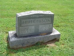
Sarah Ann Hall Hutchison
| Birth | : | 18 Sep 1854 Moniteau County, Missouri, USA |
| Death | : | 4 Jun 1932 Latham, Moniteau County, Missouri, USA |
| Burial | : | Eden Gardens Memorial Park, Warwick, Southern Downs Region, Australia |
| Coordinate | : | -28.2229690, 152.0031130 |
| Description | : | Name: Sarah Ann Hutchison Husband: George W. Hutchison Father: Morris B. Hall Birth State: Kentucky Mother: Lucinda (Jones) Hall Birth State: Kentucky Informant: Edward Hutchison Occupation: Housewife Married Status: Married Age: 77Y - 9M - 16D Gender: Female Race: White Cause of Death: Pariflezia/Malnutrition Place of Burial: Flag Spring Cemetery Burial: June 5, 1932 Source: Death Certificate: #20187 RESEARCHED BY RICHARD PARKER |
frequently asked questions (FAQ):
-
Where is Sarah Ann Hall Hutchison's memorial?
Sarah Ann Hall Hutchison's memorial is located at: Eden Gardens Memorial Park, Warwick, Southern Downs Region, Australia.
-
When did Sarah Ann Hall Hutchison death?
Sarah Ann Hall Hutchison death on 4 Jun 1932 in Latham, Moniteau County, Missouri, USA
-
Where are the coordinates of the Sarah Ann Hall Hutchison's memorial?
Latitude: -28.2229690
Longitude: 152.0031130
Family Members:
Spouse

Children
Flowers:


Nearby Cemetories:
1. Eden Gardens Memorial Park
Warwick, Southern Downs Region, Australia
Coordinate: -28.2229690, 152.0031130
2. Warwick General Lawn Cemetery
Warwick, Southern Downs Region, Australia
Coordinate: -28.2106310, 152.0039087
3. Warwick General Cemetery
Warwick, Southern Downs Region, Australia
Coordinate: -28.2100890, 152.0044080
4. Warwick War Cemetery
Warwick, Southern Downs Region, Australia
Coordinate: -28.2089620, 152.0033530
5. Lone Grave Warwick
Warwick, Southern Downs Region, Australia
Coordinate: -28.2316590, 151.9833180
6. St Marks Anglican Church Columbarium Wall
Warwick, Southern Downs Region, Australia
Coordinate: -28.2161000, 152.0347600
7. Warwick-Conway Family Homestead Cemetery
Warwick, Southern Downs Region, Australia
Coordinate: -28.1258400, 152.0395700
8. Swan Creek Anglican Cemetery
Swan Creek, Southern Downs Region, Australia
Coordinate: -28.1974400, 152.1364830
9. Glengallan Station
Warwick, Southern Downs Region, Australia
Coordinate: -28.1027016, 152.0585067
10. Yangan Presbyterian Church Cemetery
Yangan, Southern Downs Region, Australia
Coordinate: -28.1972310, 152.2142130
11. Yangan General and Anglican Cemetery
Emu Vale, Southern Downs Region, Australia
Coordinate: -28.2059990, 152.2207110
12. Allora Cemetery
Allora, Southern Downs Region, Australia
Coordinate: -28.0199230, 151.9750720
13. Dalveen-Mitchell Family Homestead Cemetery
Dalveen, Southern Downs Region, Australia
Coordinate: -28.4423200, 151.9604000
14. Pratten Cemetery
Pratten, Southern Downs Region, Australia
Coordinate: -28.0858450, 151.7790540
15. Maryvale Homestead Cemetery
Warwick, Southern Downs Region, Australia
Coordinate: -28.0669430, 152.2405230
16. Strath Elbess Cemetery
Dalveen, Southern Downs Region, Australia
Coordinate: -28.4883070, 151.9692850
17. Killarney Lawn Cemetery
Killarney, Southern Downs Region, Australia
Coordinate: -28.3475760, 152.2742790
18. Maryvale Cemetery
Maryvale, Southern Downs Region, Australia
Coordinate: -28.0607800, 152.2474610
19. Clifton General Cemetery
Clifton, Toowoomba Region, Australia
Coordinate: -27.9389150, 151.9120790
20. Headington Hill Lutheran Cemetery
Allora, Southern Downs Region, Australia
Coordinate: -27.9037210, 152.0020290
21. Back Plains Cemetery
Back Plains, Toowoomba Region, Australia
Coordinate: -27.9121770, 151.7970240
22. Spicers Gap
Boonah, Scenic Rim Region, Australia
Coordinate: -28.0733318, 152.4255524
23. Nobby Cemetery
Nobby, Toowoomba Region, Australia
Coordinate: -27.8322200, 151.8662000
24. Leyburn Cemetery
Leyburn, Southern Downs Region, Australia
Coordinate: -28.0085654, 151.5913366