
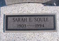
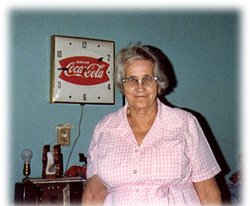
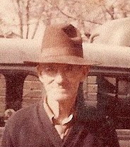
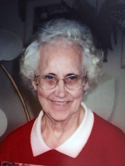
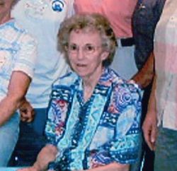
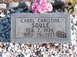
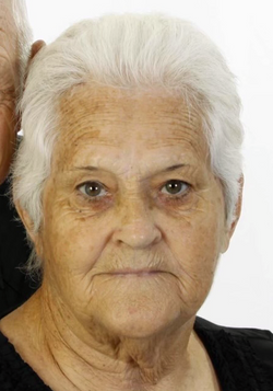
Sarah Emma Cronk Soule
| Birth | : | 27 May 1903 Butler County, Kansas, USA |
| Death | : | 21 Jul 1994 Eureka, Greenwood County, Kansas, USA |
| Burial | : | Pleasantville Cemetery, Pleasantville, Sullivan County, USA |
| Coordinate | : | 38.9651985, -87.2471008 |
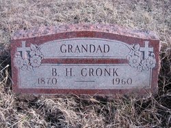
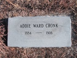
| Description | : | Sarah Emma Soule, 91, homemaker, died Thursday, July 21, 1994, at Medicalodge of Eureka. Services are 10:30 a.m. Monday at Campbell-Kelley Funeral Home with Dr. Gilbert Daniel officiating. Burial will be in the Economy Cemetery, rural El Dorado. She was born May 27, 1903, in Butler County, the daughter of B.H. and Addie B. (Ward) Cronk and she attended Pontiac School. On Jan. 27, 1920, she and Freeman Wilber Soule were married in Carthage, Mo., and they lived in Butler County until moving to Greenwood County in 1929. He died May 19, 1961. Survivors include: sons,... Read More |
frequently asked questions (FAQ):
-
Where is Sarah Emma Cronk Soule's memorial?
Sarah Emma Cronk Soule's memorial is located at: Pleasantville Cemetery, Pleasantville, Sullivan County, USA.
-
When did Sarah Emma Cronk Soule death?
Sarah Emma Cronk Soule death on 21 Jul 1994 in Eureka, Greenwood County, Kansas, USA
-
Where are the coordinates of the Sarah Emma Cronk Soule's memorial?
Latitude: 38.9651985
Longitude: -87.2471008
Family Members:
Parent
Spouse
Children


Flowers:


Nearby Cemetories:
1. Pleasantville Cemetery
Pleasantville, Sullivan County, USA
Coordinate: 38.9651985, -87.2471008
2. Morris Cemetery
Summit, Greene County, USA
Coordinate: 38.9636000, -87.2267000
3. Moody Cemetery
Pleasantville, Sullivan County, USA
Coordinate: 38.9811000, -87.2491000
4. McDade Cemetery
Sullivan County, USA
Coordinate: 38.9762800, -87.2667600
5. Burris Chapel Cemetery
Greene County, USA
Coordinate: 38.9867935, -87.2308426
6. Goodman-Mayfield Cemetery
Island City, Greene County, USA
Coordinate: 38.9942000, -87.2292000
7. Mount Moriah Cemetery
Dugger, Sullivan County, USA
Coordinate: 38.9985085, -87.2600098
8. Douthit Family Cemetery
Sullivan County, USA
Coordinate: 38.9315640, -87.2882220
9. Posey Cemetery
Bucktown, Sullivan County, USA
Coordinate: 38.9911003, -87.2968979
10. Stafford Cemetery
Greene County, USA
Coordinate: 38.9483620, -87.1865010
11. Hale Cemetery
Sullivan County, USA
Coordinate: 39.0158005, -87.2453003
12. Indian Prairie Baptist Church Cemetery
Bucktown, Sullivan County, USA
Coordinate: 38.9479523, -87.3085327
13. Bethel Cemetery
Marco, Greene County, USA
Coordinate: 38.9195680, -87.2166440
14. Bethany Cemetery
Dugger, Sullivan County, USA
Coordinate: 38.9848404, -87.3127594
15. Morris Chapel Cemetery
Stockton Township, Greene County, USA
Coordinate: 39.0241547, -87.2371445
16. Ferree Cemetery
Dugger, Sullivan County, USA
Coordinate: 39.0120811, -87.3050461
17. Trimble Cemetery
Sullivan County, USA
Coordinate: 38.9768982, -87.3302994
18. Chambers-Moore Cemetery
Dugger, Sullivan County, USA
Coordinate: 39.0294725, -87.2673484
19. Woodward Cemetery
Dugger, Sullivan County, USA
Coordinate: 39.0303001, -87.2677994
20. Carrico Cemetery
Sullivan County, USA
Coordinate: 39.0047000, -87.3206000
21. Pirtle Cemetery
Shiloh, Sullivan County, USA
Coordinate: 39.0218430, -87.3006210
22. Smith Cemetery
Dugger, Sullivan County, USA
Coordinate: 39.0175018, -87.3078003
23. Booker Cemetery
Sullivan County, USA
Coordinate: 39.0114640, -87.3218570
24. Delay Cemetery
Sandborn, Knox County, USA
Coordinate: 38.8985400, -87.2048910