
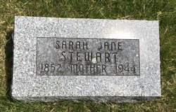
Sarah Jane “Jennie” Stipe Stewart
| Birth | : | 22 Mar 1852 Clarinda, Page County, Iowa, USA |
| Death | : | 18 Apr 1944 Grant, Montgomery County, Iowa, USA |
| Burial | : | Grant Cemetery, Grant, Montgomery County, USA |
| Coordinate | : | 41.1405983, -94.9906006 |
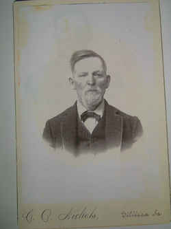
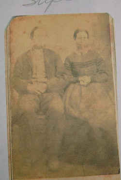
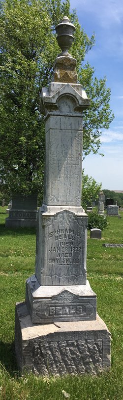
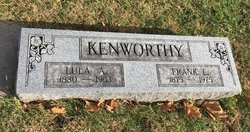
| Description | : | MRS. SARAH J. STEWART DIES AT GRANT; FINAL RITES AT 2 P.M. TODAY Mrs. Sarah Jane Stewart, 92, died Tuesday at the home of her daughter, Mrs. Frank Kenworthy at Grant. The body was brought to the Wolfe Funeral Home to await the funeral which will be held today at 2 p.m. in the Methodist church in Grant with the Rev. Orley White in charge. Burial will be in the Grant Cemetery. Villisca Review, Thursday, April 20, 1944, page 8 Sarah Stipe Stewart, buried Grant Cemetery, Grant, Iowa. She married (1) Ephriam Curtis Beals on 11 Feb 1876... Read More |
frequently asked questions (FAQ):
-
Where is Sarah Jane “Jennie” Stipe Stewart's memorial?
Sarah Jane “Jennie” Stipe Stewart's memorial is located at: Grant Cemetery, Grant, Montgomery County, USA.
-
When did Sarah Jane “Jennie” Stipe Stewart death?
Sarah Jane “Jennie” Stipe Stewart death on 18 Apr 1944 in Grant, Montgomery County, Iowa, USA
-
Where are the coordinates of the Sarah Jane “Jennie” Stipe Stewart's memorial?
Latitude: 41.1405983
Longitude: -94.9906006
Family Members:
Parent
Spouse
Siblings

Children
Flowers:


Nearby Cemetories:
1. Grant Cemetery
Grant, Montgomery County, USA
Coordinate: 41.1405983, -94.9906006
2. Old East Cemetery
Grant, Montgomery County, USA
Coordinate: 41.1444016, -94.9792023
3. Douglas Township Cemetery
Grant, Montgomery County, USA
Coordinate: 41.1360933, -94.9752558
4. Indian Burial Ground
Douglas Township, Montgomery County, USA
Coordinate: 41.0972116, -94.9752628
5. Noble Center Cemetery
Cass County, USA
Coordinate: 41.2014008, -94.9858017
6. Mortons Mill Cemetery
Morton Mills, Montgomery County, USA
Coordinate: 41.0793991, -95.0085983
7. Saint Johns UCC Cemetery
Lyman, Cass County, USA
Coordinate: 41.2160988, -94.9839020
8. Lowman Cemetery
Griswold, Cass County, USA
Coordinate: 41.1594009, -95.0886002
9. Weirich Cemetery
Cass County, USA
Coordinate: 41.2146988, -94.9655991
10. Pilot Grove Center Cemetery
Elliott, Montgomery County, USA
Coordinate: 41.1190600, -95.0993700
11. Pilot Grove Presbyterian Cemetery
Wallin, Montgomery County, USA
Coordinate: 41.0793991, -95.0699997
12. Lincoln Center Cemetery
Lincoln Center, Adams County, USA
Coordinate: 41.1161003, -94.8814011
13. Strand Cemetery
Corning, Adams County, USA
Coordinate: 41.0730000, -94.9100000
14. Reno Cemetery
Cumberland, Cass County, USA
Coordinate: 41.2009520, -94.8886050
15. Tabor Cemetery
Wallin, Montgomery County, USA
Coordinate: 41.0543700, -95.0619900
16. Thompson Cemetery
Adams County, USA
Coordinate: 41.0527000, -94.9161000
17. Bolt Family Burying Ground
Villisca, Montgomery County, USA
Coordinate: 41.0362750, -94.9950660
18. Sciola Baptist Cemetery
Montgomery County, USA
Coordinate: 41.0340000, -94.9859000
19. Newlons Grove Cemetery
Cass County, USA
Coordinate: 41.2397003, -94.9372025
20. Saint Timothy Cemetery
Cass County, USA
Coordinate: 41.1880989, -94.8619995
21. Hillside Cemetery
Elliott, Montgomery County, USA
Coordinate: 41.1408005, -95.1544037
22. Pleasant Township Cemetery
Griswold, Cass County, USA
Coordinate: 41.2056000, -95.1370000
23. Mercer Cemetery
Pottawattamie County, USA
Coordinate: 41.1753006, -95.1650009
24. Haefflick Burial Site
Red Oak, Montgomery County, USA
Coordinate: 41.0726300, -95.1561700