
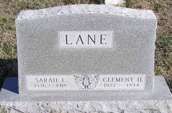

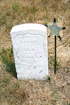
Sarah L. Senter Lane
| Birth | : | 28 Dec 1836 Ohio, USA |
| Death | : | 23 Jan 1918 |
| Burial | : | Saint Johns Cemetery, Iron Ridge, Dodge County, USA |
| Coordinate | : | 43.3711014, -88.5531006 |
frequently asked questions (FAQ):
-
Where is Sarah L. Senter Lane's memorial?
Sarah L. Senter Lane's memorial is located at: Saint Johns Cemetery, Iron Ridge, Dodge County, USA.
-
When did Sarah L. Senter Lane death?
Sarah L. Senter Lane death on 23 Jan 1918 in
-
Where are the coordinates of the Sarah L. Senter Lane's memorial?
Latitude: 43.3711014
Longitude: -88.5531006
Family Members:
Spouse
Children
Flowers:


Nearby Cemetories:
1. Saint Johns Cemetery
Iron Ridge, Dodge County, USA
Coordinate: 43.3711014, -88.5531006
2. Saint Michaels Cemetery
Iron Ridge, Dodge County, USA
Coordinate: 43.3807983, -88.5607986
3. Saint Johns Lutheran Cemetery
Woodland, Dodge County, USA
Coordinate: 43.3710785, -88.5325775
4. Saint Marys Catholic Cemetery
Woodland, Dodge County, USA
Coordinate: 43.3775000, -88.5214000
5. Saint Matthews Evangelical Lutheran Cemetery
Iron Ridge, Dodge County, USA
Coordinate: 43.3959885, -88.5283813
6. Family Cemetery
Rubicon, Dodge County, USA
Coordinate: 43.3533300, -88.5131300
7. Rex Cemetery
Iron Ridge, Dodge County, USA
Coordinate: 43.4006996, -88.5841980
8. Lehman Cemetery
Neosho, Dodge County, USA
Coordinate: 43.3319016, -88.5393982
9. Cole Cemetery
Iron Ridge, Dodge County, USA
Coordinate: 43.3853989, -88.5006485
10. Saint Bartholomew Cemetery
Neosho, Dodge County, USA
Coordinate: 43.3363991, -88.5188980
11. Iron Ridge Cemetery
Iron Ridge, Dodge County, USA
Coordinate: 43.4166450, -88.5434530
12. Hustisford Cemetery
Hustisford, Dodge County, USA
Coordinate: 43.3393500, -88.6018610
13. Saint Johns Catholic Cemetery
Woodland, Dodge County, USA
Coordinate: 43.3778000, -88.4811020
14. Methodist Cemetery
Iron Ridge, Dodge County, USA
Coordinate: 43.4135120, -88.4950880
15. Woodlawn Cemetery
Neosho, Dodge County, USA
Coordinate: 43.3114180, -88.5134770
16. Mace Methodist Cemetery
Mayville, Dodge County, USA
Coordinate: 43.4425000, -88.5553800
17. Hallowell Farm Cemetery
Rubicon, Dodge County, USA
Coordinate: 43.3518982, -88.4578018
18. Norton Farm Methodist Episcopal Christian Cemetery
Rubicon, Dodge County, USA
Coordinate: 43.3252182, -88.4757690
19. Zum Kripplein Christi Lutheran Church Cemetery
Iron Ridge, Dodge County, USA
Coordinate: 43.4289960, -88.4897550
20. Townline Cemetery
Juneau, Dodge County, USA
Coordinate: 43.3497009, -88.6549988
21. Saint Johns Cemetery
Rubicon, Dodge County, USA
Coordinate: 43.3400050, -88.4540070
22. Saint John's Lutheran Cemetery
Horicon, Dodge County, USA
Coordinate: 43.4499830, -88.5621210
23. Methodist Cemetery
Herman Center, Dodge County, USA
Coordinate: 43.3867350, -88.4314760
24. Trinity Evangelical Lutheran Church Cemetery
Herman Center, Dodge County, USA
Coordinate: 43.3839440, -88.4304360