


Sarah Moyer Long
| Birth | : | 7 Jul 1833 Centre County, Pennsylvania, USA |
| Death | : | 19 Jan 1907 Knox County, Nebraska, USA |
| Burial | : | Bedford Cemetery, Bedford Township, Calhoun County, USA |
| Coordinate | : | 42.3938103, -85.2306671 |
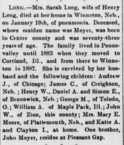
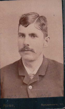
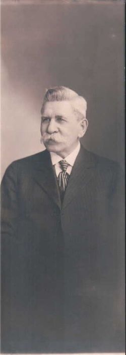
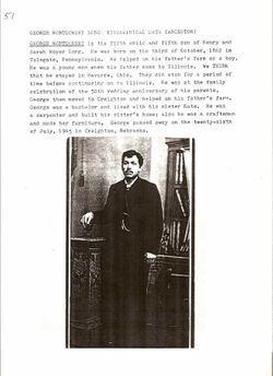
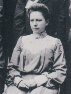
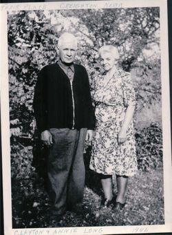
| Description | : | Sarah was married to Henry Long on Sep. 21, 1854. They lived in Pennsylvania until 1883 when she moved with her husband and family to Cortland, Ill. In 1887 they moved to Knox County, Neb. She was survived by children Daniel, Henry, Simon, Andrew, William, George, John, Mary, Katie and James. (Extracted from her obituary in Nebraska Courier, Jan. 25, 1907) |
frequently asked questions (FAQ):
-
Where is Sarah Moyer Long's memorial?
Sarah Moyer Long's memorial is located at: Bedford Cemetery, Bedford Township, Calhoun County, USA.
-
When did Sarah Moyer Long death?
Sarah Moyer Long death on 19 Jan 1907 in Knox County, Nebraska, USA
-
Where are the coordinates of the Sarah Moyer Long's memorial?
Latitude: 42.3938103
Longitude: -85.2306671
Family Members:
Spouse
Children
Flowers:


Nearby Cemetories:
1. Bedford Cemetery
Bedford Township, Calhoun County, USA
Coordinate: 42.3938103, -85.2306671
2. Harmon Halladay Cemetery
Bedford, Calhoun County, USA
Coordinate: 42.3546982, -85.2061005
3. Iden Cemetery
Banfield, Barry County, USA
Coordinate: 42.4460983, -85.2489014
4. Checkered Cemetery
Assyria Township, Barry County, USA
Coordinate: 42.4331810, -85.1698350
5. Haskell Home Cemetery
Battle Creek, Calhoun County, USA
Coordinate: 42.3350590, -85.2093310
6. Harmonia Cemetery
Bedford, Calhoun County, USA
Coordinate: 42.3436012, -85.2782974
7. Hicks Cemetery
Pennfield Township, Calhoun County, USA
Coordinate: 42.3883018, -85.1335983
8. Day Cemetery
Augusta, Kalamazoo County, USA
Coordinate: 42.3905983, -85.3285980
9. Reese Cemetery
Springfield, Calhoun County, USA
Coordinate: 42.3196983, -85.2375031
10. Saint Thomas Episcopal Church Memorial Gardens
Battle Creek, Calhoun County, USA
Coordinate: 42.3208710, -85.1795390
11. Fort Custer National Cemetery
Augusta, Kalamazoo County, USA
Coordinate: 42.3384514, -85.3191986
12. Youngs Cemetery
Battle Creek, Calhoun County, USA
Coordinate: 42.3031693, -85.2358398
13. Banfield Cemetery
Banfield, Barry County, USA
Coordinate: 42.4716988, -85.2941971
14. Memorial Park Sunset Gardens
Battle Creek, Calhoun County, USA
Coordinate: 42.3010950, -85.2393690
15. Memorial Park Cemetery
Battle Creek, Calhoun County, USA
Coordinate: 42.3005981, -85.2358017
16. Mount Olivet Cemetery
Battle Creek, Calhoun County, USA
Coordinate: 42.3074989, -85.1817017
17. Oak Hill Cemetery
Battle Creek, Calhoun County, USA
Coordinate: 42.3060989, -85.1774979
18. Ross Center Cemetery
Augusta, Kalamazoo County, USA
Coordinate: 42.3760986, -85.3619003
19. Assyria Cemetery
Assyria, Barry County, USA
Coordinate: 42.4617119, -85.1307068
20. Lacey Cemetery
Nashville, Barry County, USA
Coordinate: 42.4930475, -85.1913838
21. Augusta Cemetery
Augusta, Kalamazoo County, USA
Coordinate: 42.3392240, -85.3566830
22. Bell Cemetery
Assyria Township, Barry County, USA
Coordinate: 42.4427986, -85.0963974
23. East Hickory Corners Cemetery
Hickory Corners, Barry County, USA
Coordinate: 42.4408302, -85.3711090
24. Union Cemetery
Maple Grove Township, Barry County, USA
Coordinate: 42.5085983, -85.1900024