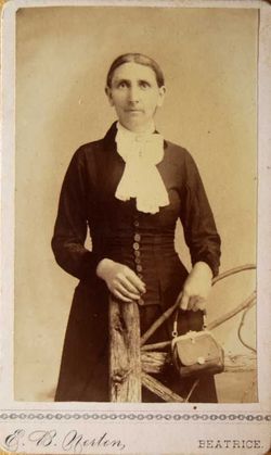
| Birth | : | 1836 Illinois, USA |
| Death | : | 14 Mar 1913 |
| Burial | : | St Helena Churchyard, South Scarle, Newark and Sherwood District, England |
| Coordinate | : | 53.1665600, -0.7326100 |
| Plot | : | Lot 516 UNMARKED |
| Description | : | Aged 77 years. 1885 Nebraska state Census Silas (Indexed as Kenupp), 50 - with wife - Annie, age 46 in Beatrice, NE. |
frequently asked questions (FAQ):
-
Where is Silas Keneipp's memorial?
Silas Keneipp's memorial is located at: St Helena Churchyard, South Scarle, Newark and Sherwood District, England.
-
When did Silas Keneipp death?
Silas Keneipp death on 14 Mar 1913 in
-
Where are the coordinates of the Silas Keneipp's memorial?
Latitude: 53.1665600
Longitude: -0.7326100
Family Members:
Spouse
Flowers:
Nearby Cemetories:
1. St Helena Churchyard
South Scarle, Newark and Sherwood District, England
Coordinate: 53.1665600, -0.7326100
2. All Saints' Churchyard
Swinderby, North Kesteven District, England
Coordinate: 53.1587100, -0.7017900
3. Holy Trinity Churchyard
Besthorpe, Newark and Sherwood District, England
Coordinate: 53.1731600, -0.7664200
4. Collingham North All Saints Churchyard
Collingham, Newark and Sherwood District, England
Coordinate: 53.1490600, -0.7607900
5. All Saints Churchyard
North Scarle, North Kesteven District, England
Coordinate: 53.1909430, -0.7318880
6. St Cecilla Churchyard
Girton, Newark and Sherwood District, England
Coordinate: 53.1865300, -0.7663100
7. St. John the Baptist Churchyard
Collingham, Newark and Sherwood District, England
Coordinate: 53.1425550, -0.7656640
8. All Saints Churchyard
Eagle, North Kesteven District, England
Coordinate: 53.1947490, -0.6904180
9. St Mary's Churchyard
Carlton-on-Trent, Newark and Sherwood District, England
Coordinate: 53.1665950, -0.8058160
10. All Saints Churchyard
Sutton-on-Trent, Newark and Sherwood District, England
Coordinate: 53.1846400, -0.8032700
11. Sutton on Trent Cemetery
Sutton-on-Trent, Newark and Sherwood District, England
Coordinate: 53.1876600, -0.8028300
12. St Giles Churchyard
Cromwell, Newark and Sherwood District, England
Coordinate: 53.1449750, -0.8063850
13. St Bartholomew Churchyard
Langford, Newark and Sherwood District, England
Coordinate: 53.1225760, -0.7743940
14. Saint Michael and All Angels Churchyard
Thorpe-on-the-Hill, North Kesteven District, England
Coordinate: 53.1784800, -0.6418800
15. St Michael's Church
Norton Disney, North Kesteven District, England
Coordinate: 53.1204000, -0.6795000
16. St Germain Churchyard
Thurlby, South Kesteven District, England
Coordinate: 53.1447870, -0.6425330
17. St Peter's Churchyard
Norton Disney, North Kesteven District, England
Coordinate: 53.1203200, -0.6716900
18. St. Peter's Churchyard
Norton Disney, North Kesteven District, England
Coordinate: 53.1203000, -0.6717000
19. St Wilfrid's Churchyard
Marnham, Bassetlaw District, England
Coordinate: 53.2155000, -0.7933000
20. All Saints Churchyard
Harby, Newark and Sherwood District, England
Coordinate: 53.2242190, -0.6860660
21. Brotts Road Cemetery
Normanton-on-Trent, Bassetlaw District, England
Coordinate: 53.2092038, -0.8128064
22. St Peter Churchyard
Aubourn, North Kesteven District, England
Coordinate: 53.1518050, -0.6264200
23. St. Michael's Churchyard
Bassingham, North Kesteven District, England
Coordinate: 53.1265350, -0.6431400
24. All Saints Churchyard
Stapleford, North Kesteven District, England
Coordinate: 53.1082000, -0.6776500

