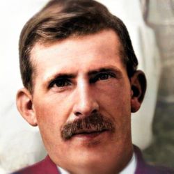
| Birth | : | 22 Aug 1838 Greenfield, Greene County, Illinois, USA |
| Death | : | 20 Feb 1880 Fort Benton, Chouteau County, Montana, USA |
| Burial | : | Riverside Cemetery, Fort Benton, Chouteau County, USA |
| Coordinate | : | 47.8402330, -110.6408830 |
| Description | : | Solomon was educated in the country schools of Andrew and Gentry counties, MO which was completed at age 21 and he went to Donovan County, KS where he took a homestead. He farmed and engaged in general mercantile business in Wathena, KS. In 1861 he joined General Lee's army as a lieutenant. On Monday, April 27, 1863 he was caught playing with cards for money at the usual hour for dress parade of his Battalion and by his example encouraged enlisted men to absent themselves therefrom. He tendered his resignation as Sr. 2nd Lt. in Co. A, Missouri... Read More |
frequently asked questions (FAQ):
-
Where is Solomon Hill Miller's memorial?
Solomon Hill Miller's memorial is located at: Riverside Cemetery, Fort Benton, Chouteau County, USA.
-
When did Solomon Hill Miller death?
Solomon Hill Miller death on 20 Feb 1880 in Fort Benton, Chouteau County, Montana, USA
-
Where are the coordinates of the Solomon Hill Miller's memorial?
Latitude: 47.8402330
Longitude: -110.6408830
Family Members:
Parent
Spouse
Siblings
Children
Flowers:
Nearby Cemetories:
1. Riverside Cemetery
Fort Benton, Chouteau County, USA
Coordinate: 47.8402330, -110.6408830
2. Old Shep Gravesite
Fort Benton, Chouteau County, USA
Coordinate: 47.8369000, -110.6557000
3. Museum of the Upper Missouri
Fort Benton, Chouteau County, USA
Coordinate: 47.8207000, -110.6642000
4. Montague Cemetery
Chouteau County, USA
Coordinate: 47.6783000, -110.4670000
5. Carter Cemetery
Carter, Chouteau County, USA
Coordinate: 47.7852000, -110.9616000
6. Clear Lake Cemetery
Chouteau County, USA
Coordinate: 47.7731018, -110.2514038
7. Upper Shonkin Cemetery
Chouteau County, USA
Coordinate: 47.5220000, -110.5770000
8. Upper Highwood Cemetery
Chouteau County, USA
Coordinate: 47.5092010, -110.6881027
9. Twin Hills Colony Cemetery
Chouteau County, USA
Coordinate: 48.0142000, -111.0720000
10. Keaster Cemetery
Chouteau County, USA
Coordinate: 47.5093500, -110.7410000
11. Geraldine Cemetery
Geraldine, Chouteau County, USA
Coordinate: 47.5965500, -110.2578000
12. Sample Flat Cemetery
Chouteau County, USA
Coordinate: 48.0175018, -111.1224976
13. Graceville Cemetery
Chouteau County, USA
Coordinate: 47.7505989, -110.0875015
14. Wolf Cemetery
Liberty County, USA
Coordinate: 48.1617620, -110.9984420
15. Kenilworth Cemetery
Chouteau County, USA
Coordinate: 48.2192001, -110.4188995
16. Riverview Colony Cemetery
Riverview Colony, Liberty County, USA
Coordinate: 48.1762000, -111.0315000
17. Big Willow Cemetery
Belt, Cascade County, USA
Coordinate: 47.4164009, -110.7444000
18. McLeish Cemetery
Judith Basin County, USA
Coordinate: 47.3596992, -110.5772018
19. Big Sandy Cemetery
Big Sandy, Chouteau County, USA
Coordinate: 48.1801170, -110.1207500
20. Square Butte Bench Cemetery
Chouteau County, USA
Coordinate: 47.5539017, -110.0447006
21. Memory Gardens Pet Cemetery
Great Falls, Cascade County, USA
Coordinate: 47.4642000, -111.1287000
22. Pleasant View Cemetery
Belt, Cascade County, USA
Coordinate: 47.3722000, -110.9088974
23. Knees Church Cemetery
Fort Benton, Chouteau County, USA
Coordinate: 47.9875000, -111.3621000
24. Erickson Cemetery
Liberty County, USA
Coordinate: 48.3143997, -110.9503021

