
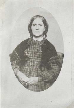
| Birth | : | 7 Dec 1811 Wilton, Franklin County, Maine, USA |
| Death | : | Feb 1889 Turner County, South Dakota, USA |
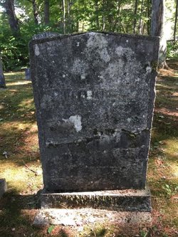
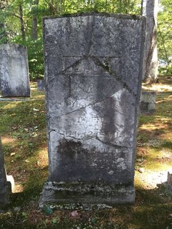
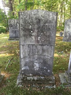
| Burial | : | Mount Hope Cemetery, Ashland, Ashland County, USA |
| Coordinate | : | 46.5621986, -90.9039001 |
| Description | : | Daughter of Shubael and Betsy Washburn Pease. She married James Parker Withee in 1835 in Sommerset Co., Maine. They had eight children. They came to Dakota Territory in 1874 from Illinois with a group of relatives, and homesteaded in Turner County. She died in 1889 and, a few years after her death, James Withee returned to Illinois to live with his nephew, Frank Graves. ********** Children: Adelaide F. Withee (1836) Wife of James Nesbit Louisa Samantha Withee (1838) Married name Graves James Albert Withee (1840 - 1905) Sophronia (Emma) Withee (1843) Ephraim H. Withee (1846 - 1935) Lydia E. Withee (1848) E. Withee (1848) Charles Henry Withee (1855 - 1937) Siblings: Sarah,... Read More |
frequently asked questions (FAQ):
-
Where is Sophronia Pease Withee's memorial?
Sophronia Pease Withee's memorial is located at: Mount Hope Cemetery, Ashland, Ashland County, USA.
-
When did Sophronia Pease Withee death?
Sophronia Pease Withee death on Feb 1889 in Turner County, South Dakota, USA
-
Where are the coordinates of the Sophronia Pease Withee's memorial?
Latitude: 46.5621986
Longitude: -90.9039001
Family Members:
Parent
Spouse
Siblings

Children
Flowers:


Nearby Cemetories:
1. Mount Hope Cemetery
Ashland, Ashland County, USA
Coordinate: 46.5621986, -90.9039001
2. Saint Agnes Cemetery
Ashland, Ashland County, USA
Coordinate: 46.5614014, -90.9075012
3. B'Nai Israel Cemetery
Ashland, Ashland County, USA
Coordinate: 46.5600014, -90.9116974
4. Heitsch Family Burial Plot
Barksdale, Bayfield County, USA
Coordinate: 46.6315661, -90.9560996
5. Church Corner Cemetery
Washburn, Bayfield County, USA
Coordinate: 46.6595000, -90.9889000
6. Moquah National Cemetery
Moquah, Bayfield County, USA
Coordinate: 46.5702860, -91.0718390
7. Moquah Cemetery
Moquah, Bayfield County, USA
Coordinate: 46.5701980, -91.0731530
8. Woodland Cemetery
Washburn, Bayfield County, USA
Coordinate: 46.6845100, -90.9049800
9. Calvary Cemetery
Washburn, Bayfield County, USA
Coordinate: 46.6852989, -90.9008026
10. Saints Peter and Paul Catholic Cemetery
Moquah, Bayfield County, USA
Coordinate: 46.5698013, -91.0842972
11. Saint Peters Cemetery
Benoit, Bayfield County, USA
Coordinate: 46.5236015, -91.0781021
12. Old Apostolic Lutheran Cemetery
Marengo, Ashland County, USA
Coordinate: 46.4408640, -90.8473530
13. Bad River Cemetery
Odanah, Ashland County, USA
Coordinate: 46.5992100, -90.7208900
14. Saint Anne Catholic Cemetery
Sanborn, Ashland County, USA
Coordinate: 46.4294281, -90.9071426
15. Benoit Cemetery
Benoit, Bayfield County, USA
Coordinate: 46.5026016, -91.0794983
16. Old Calvary Cemetery
Washburn, Bayfield County, USA
Coordinate: 46.7072906, -90.8947830
17. Fish Creek Cemetery
Ino, Bayfield County, USA
Coordinate: 46.5241165, -91.1252823
18. Moland Lutheran Church Cemetery
Mason, Bayfield County, USA
Coordinate: 46.4131012, -90.9897995
19. Mason Cemetery
Mason, Bayfield County, USA
Coordinate: 46.4401800, -91.0555800
20. Maple Grove Cemetery
Marengo, Ashland County, USA
Coordinate: 46.3852997, -90.8606033
21. Moe Cemetery
Mason, Bayfield County, USA
Coordinate: 46.3789200, -90.9498900
22. Saint Florians Cemetery
Ino, Bayfield County, USA
Coordinate: 46.5161438, -91.1750412
23. Birch Lake Cemetery
Mason, Bayfield County, USA
Coordinate: 46.3569603, -90.9666595
24. Mount Hope Cemetery
High Bridge, Ashland County, USA
Coordinate: 46.3859700, -90.7353300