
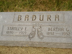
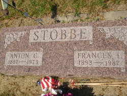
Stanislaus E “Stanley” Badura
| Birth | : | 23 Nov 1890 Chicago, Cook County, Illinois, USA |
| Death | : | Apr 1969 Grand Island, Hall County, Nebraska, USA |
| Burial | : | Saint Francis Cemetery, Ashton, Sherman County, USA |
| Coordinate | : | 41.2438000, -98.7994000 |
| Description | : | BADURA, STANLEY E: Merchant; b Chicago, Ill Nov 23, 1890; son of Frank X Badura and Elenora Badura; educated in Ashton High School; married Bertha Jamrog on Sept 27, 1914 in Ashton; son Donald; daughter Marie; -while in school, he assisted his father in general merc business, Ashton; after finishing school was in business with father until his retirement 1939; 1939 with brother Peter I in F X Badura & Sons, general merc business, Ashton; member city council; director of Ashton State Bank; past member board of education 12 years; Federation of Nebraska Retailers; KC; St Francis Catholic Church; hobbies were... Read More |
frequently asked questions (FAQ):
-
Where is Stanislaus E “Stanley” Badura's memorial?
Stanislaus E “Stanley” Badura's memorial is located at: Saint Francis Cemetery, Ashton, Sherman County, USA.
-
When did Stanislaus E “Stanley” Badura death?
Stanislaus E “Stanley” Badura death on Apr 1969 in Grand Island, Hall County, Nebraska, USA
-
Where are the coordinates of the Stanislaus E “Stanley” Badura's memorial?
Latitude: 41.2438000
Longitude: -98.7994000
Family Members:
Parent
Spouse

Siblings
Children

Flowers:


Nearby Cemetories:
1. Saint Francis Cemetery
Ashton, Sherman County, USA
Coordinate: 41.2438000, -98.7994000
2. Union Cemetery
Ashton, Sherman County, USA
Coordinate: 41.2214012, -98.7855988
3. Immanuel Lutheran Cemetery
Ashton, Sherman County, USA
Coordinate: 41.2140000, -98.8142000
4. Mount Carmel Cemetery
Howard County, USA
Coordinate: 41.2797012, -98.7328033
5. Austin Cemetery
Rockville, Sherman County, USA
Coordinate: 41.1880989, -98.8981018
6. Dannevirke Cemetery
Dannevirke, Howard County, USA
Coordinate: 41.3227997, -98.6986008
7. Saint Marys Cemetery
Rockville, Sherman County, USA
Coordinate: 41.1202000, -98.8255000
8. Kelso Cemetery
Howard County, USA
Coordinate: 41.1627998, -98.6707993
9. Danish Lutheran Cemetery
Farwell, Howard County, USA
Coordinate: 41.2134660, -98.6336020
10. Saint Anthony Catholic Cemetery
Farwell, Howard County, USA
Coordinate: 41.1845400, -98.6414700
11. Ebenezer Cemetery
Howard County, USA
Coordinate: 41.1264000, -98.7097015
12. Czechoslovakia Cemetery
Farwell, Howard County, USA
Coordinate: 41.2132988, -98.6224976
13. Scotch Cemetery
Farwell, Howard County, USA
Coordinate: 41.1917000, -98.6130981
14. Evergreen Cemetery
Loup City, Sherman County, USA
Coordinate: 41.2997017, -98.9852982
15. Saint Josaphats Cemetery
Loup City, Sherman County, USA
Coordinate: 41.3022003, -98.9847031
16. Verdurette Cemetery
Sherman County, USA
Coordinate: 41.1697006, -98.9757996
17. Bohemian National Graveyard
Howard County, USA
Coordinate: 41.2492070, -98.5927620
18. Cotesfield Cemetery
Cotesfield, Howard County, USA
Coordinate: 41.3358002, -98.6219025
19. Hayestown Cemetery
Rockville, Sherman County, USA
Coordinate: 41.0766983, -98.8043976
20. Souleville Cemetery
Sherman County, USA
Coordinate: 41.0782080, -98.7553360
21. Zeller Burial Site
Rockville, Sherman County, USA
Coordinate: 41.0725000, -98.8056000
22. Loup Fork Cemetery
Boelus, Howard County, USA
Coordinate: 41.1052600, -98.6631000
23. Saint Josephs Cemetery
Elba, Howard County, USA
Coordinate: 41.2930984, -98.5746994
24. Saint Wenceslaus Cemetery
Howard County, USA
Coordinate: 41.2056007, -98.5702972