
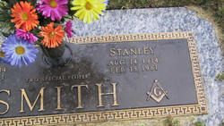
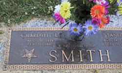
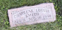
Stanley Smith
| Birth | : | 14 Aug 1914 Madison County, Iowa, USA |
| Death | : | 15 Feb 1981 Des Moines, Polk County, Iowa, USA |
| Burial | : | Ford Cemetery, Ford, Metropolitan Borough of Sefton, England |
| Coordinate | : | 53.4824040, -2.9925980 |
| Plot | : | Section - Devotion, Lot - 42, Space - 3 |
| Description | : | Winterset Madisonian, Winterset, Iowa February 1981 Services Held For STANLEY SMITH Services will be held Thursday, Feb. 19, at Lorimor United Methodist Church for Stanley Smith, who died Sunday, Feb. 15, 1981 at Iowa Methodist Medical Center in Des Moines. He was born August 14, 1914 in Madison County, Iowa. He was the son of Charlie M. Smith and Gertrude Neeley. In 1939 he married Charlotte Spencer in Nashua, Iowa. Five children were born of this union. He was a farmer all of his life, which he spent in Union County. He was a member of... Read More |
frequently asked questions (FAQ):
-
Where is Stanley Smith's memorial?
Stanley Smith's memorial is located at: Ford Cemetery, Ford, Metropolitan Borough of Sefton, England.
-
When did Stanley Smith death?
Stanley Smith death on 15 Feb 1981 in Des Moines, Polk County, Iowa, USA
-
Where are the coordinates of the Stanley Smith's memorial?
Latitude: 53.4824040
Longitude: -2.9925980
Family Members:
Parent
Spouse
Siblings

Children
Flowers:


Nearby Cemetories:
1. Ford Cemetery
Ford, Metropolitan Borough of Sefton, England
Coordinate: 53.4824040, -2.9925980
2. Thornton Garden of Rest and Crematorium
Thornton, Metropolitan Borough of Sefton, England
Coordinate: 53.5001850, -2.9951960
3. St Faiths Churchyard
Waterloo, Metropolitan Borough of Sefton, England
Coordinate: 53.4810510, -3.0230370
4. St Peter and St Paul Churchyard
Crosby, Metropolitan Borough of Sefton, England
Coordinate: 53.4858300, -3.0234920
5. St Luke Churchyard
Great Crosby, Metropolitan Borough of Sefton, England
Coordinate: 53.4909310, -3.0240300
6. Bootle Cemetery
Bootle, Metropolitan Borough of Sefton, England
Coordinate: 53.4627680, -2.9787450
7. Aintree Racecourse Grounds
Aintree Village, Metropolitan Borough of Sefton, England
Coordinate: 53.4733880, -2.9549700
8. Harkirk Burial Ground
Little Crosby, Metropolitan Borough of Sefton, England
Coordinate: 53.5016890, -3.0191220
9. Sefton Parish Churchyard
Sefton, Metropolitan Borough of Sefton, England
Coordinate: 53.5044060, -2.9712190
10. Walton Park Cemetery
Walton, Metropolitan Borough of Liverpool, England
Coordinate: 53.4564370, -2.9695960
11. Kirkdale Cemetery
Liverpool, Metropolitan Borough of Liverpool, England
Coordinate: 53.4672530, -2.9479800
12. St. Mary Roman Catholic Churchyard
Little Crosby, Metropolitan Borough of Sefton, England
Coordinate: 53.5076380, -3.0274720
13. St. Mary's Churchyard
Bootle, Metropolitan Borough of Sefton, England
Coordinate: 53.4492620, -3.0006520
14. Rice Lane Jewish Cemetery
Walton, Metropolitan Borough of Liverpool, England
Coordinate: 53.4521700, -2.9590600
15. St Mary the Virgin Churchyard
Walton, Metropolitan Borough of Liverpool, England
Coordinate: 53.4464930, -2.9673330
16. Everton Cemetery
Everton, Metropolitan Borough of Liverpool, England
Coordinate: 53.4555430, -2.9442480
17. Long Lane Jewish Cemetery
Liverpool, Metropolitan Borough of Liverpool, England
Coordinate: 53.4550140, -2.9420480
18. St. Andrew Churchyard
Maghull, Metropolitan Borough of Sefton, England
Coordinate: 53.5104770, -2.9428820
19. St. Alexander Church
Bootle, Metropolitan Borough of Sefton, England
Coordinate: 53.4401090, -2.9922250
20. Ince Blundell Cemetery
Ince Blundell, Metropolitan Borough of Sefton, England
Coordinate: 53.5213570, -3.0208750
21. Melling Churchyard
Melling, Metropolitan Borough of Sefton, England
Coordinate: 53.4953370, -2.9228780
22. St Thomas and the Holy Rood Churchyard
Melling, Metropolitan Borough of Sefton, England
Coordinate: 53.4954510, -2.9227850
23. St Luke Churchyard
Walton, Metropolitan Borough of Liverpool, England
Coordinate: 53.4396910, -2.9671400
24. Kirkdale Goal Cemetery
Kirkdale, Metropolitan Borough of Liverpool, England
Coordinate: 53.4361110, -2.9802780