
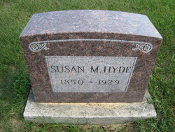
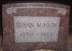
Susan M. Kuntz Hyde
| Birth | : | 13 Jul 1846 Noble County, Ohio, USA |
| Death | : | 3 Jan 1929 Brock, Scotland County, Missouri, USA |
| Burial | : | St. Peter and St. Paul's Churchyard, Salle, Broadland District, England |
| Coordinate | : | 52.7802370, 1.1276420 |
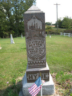
| Description | : | On February 5, 1878, Susan Kuntz married widower Cyrus Lyens Hyde. The couple lived in the Brock community in Union Township, Scotland County, Missouri, and had one child, Violet Augusta "Gussie" Hyde. Note: the birthdate on her tombstone is different than that reported on her death certificate and in her published obituary. Obituaries Memphis Reveille, Memphis, Missouri, January 3, 1929 (used with permission) Mrs. Sue Hyde Died This Morning Mrs. Sue Hyde, aged in the eighties, died this morning at her home east of Brock. She had suffered with the flu, which together with her advanced age, caused her demise. Her husband,... Read More |
frequently asked questions (FAQ):
-
Where is Susan M. Kuntz Hyde's memorial?
Susan M. Kuntz Hyde's memorial is located at: St. Peter and St. Paul's Churchyard, Salle, Broadland District, England.
-
When did Susan M. Kuntz Hyde death?
Susan M. Kuntz Hyde death on 3 Jan 1929 in Brock, Scotland County, Missouri, USA
-
Where are the coordinates of the Susan M. Kuntz Hyde's memorial?
Latitude: 52.7802370
Longitude: 1.1276420
Family Members:
Spouse
Children
Flowers:


Nearby Cemetories:
1. St. Peter and St. Paul's Churchyard
Salle, Broadland District, England
Coordinate: 52.7802370, 1.1276420
2. St. Mary's Churchyard
Reepham, Broadland District, England
Coordinate: 52.7623070, 1.1128810
3. All Saints Churchyard, Hackford
Reepham, Broadland District, England
Coordinate: 52.7622480, 1.1122220
4. St. Peter and St. Paul's Churchyard
Heydon, Broadland District, England
Coordinate: 52.8027280, 1.1345020
5. St. Agnes Churchyard
Cawston, Broadland District, England
Coordinate: 52.7702040, 1.1617360
6. Reepham Cemetery
Reepham, Broadland District, England
Coordinate: 52.7595078, 1.1082559
7. St. Michael the Archangel Churchyard
Booton, Broadland District, England
Coordinate: 52.7575040, 1.1446340
8. Cawston Cemetery
Cawston, Broadland District, England
Coordinate: 52.7695320, 1.1666930
9. St. Andrew's Churchyard
Wood Dalling, Broadland District, England
Coordinate: 52.8001170, 1.0985350
10. St. Peter & St. Paul's Churchyard
Oulton, Broadland District, England
Coordinate: 52.8114317, 1.1685485
11. St. Peter's Churchyard
Corpusty, North Norfolk District, England
Coordinate: 52.8207280, 1.1371910
12. St. Nicholas' Churchyard
Brandiston, Broadland District, England
Coordinate: 52.7479240, 1.1712620
13. St. Faith Churchyard
Little Witchingham, Broadland District, England
Coordinate: 52.7382900, 1.1322470
14. St. Mary's Churchyard
Great Witchingham, Broadland District, England
Coordinate: 52.7370860, 1.1142140
15. St Peter
Guestwick, Broadland District, England
Coordinate: 52.8014270, 1.0565010
16. St. Andrew's Churchyard
Saxthorpe, North Norfolk District, England
Coordinate: 52.8299250, 1.1398600
17. St. Peter's Churchyard
Haveringland, Broadland District, England
Coordinate: 52.7427900, 1.1857300
18. St. Margaret of Swannington Churchyard
Swannington, Broadland District, England
Coordinate: 52.7289500, 1.1591660
19. St. John the Baptist Churchyard
Alderford, Broadland District, England
Coordinate: 52.7248870, 1.1435180
20. Matthews Family Mausoleum
Great Witchingham, Broadland District, England
Coordinate: 52.7238450, 1.1259340
21. St. Mary's Churchyard
Sparham, Breckland Borough, England
Coordinate: 52.7349340, 1.0661850
22. St Mary Churchyard
Itteringham, North Norfolk District, England
Coordinate: 52.8334650, 1.1826370
23. All Saints Churchyard
Bawdeswell, Breckland Borough, England
Coordinate: 52.7469490, 1.0307670
24. Bawdeswell Cemetery
Bawdeswell, Breckland Borough, England
Coordinate: 52.7446450, 1.0328570