Ted Dale Pendry
| Birth | : | May 1917 Lincoln County, Washington, USA |
| Death | : | 1962 |
| Burial | : | Denton Cemetery, Denton, Metropolitan Borough of Tameside, England |
| Coordinate | : | 53.4424140, -2.1115510 |
| Plot | : | 1948 Plat Section |
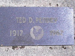
| Inscription | : | TEC D. PENDRY 1917 ~ 1962 |
| Description | : | NOTE: Two different days of birth in records below; either 23 May (birth transcription) or 10 May (WWII registration card). Washington, U.S., Birth Index, 1907-1919 Name: Ted Dale Pendry Birth Date: *23 May 1917 Location: Lincoln [County] Race: White Father's Name: Lee Pendry Mother's Name: Mamie Sheets Image Filename: 4567 ================ NOTE: Born in Peach, Lincoln County, Washington. On 9 April, 1939, the United States post office in Peach is officially decommissioned, as the town is dismantled in preparation for the rising waters that will form Franklin D. Roosevelt Lake, the 150-mile reservoir behind Grand Coulee Dam. Peach... Read More |
frequently asked questions (FAQ):
-
Where is Ted Dale Pendry's memorial?
Ted Dale Pendry's memorial is located at: Denton Cemetery, Denton, Metropolitan Borough of Tameside, England.
-
When did Ted Dale Pendry death?
Ted Dale Pendry death on 1962 in
-
Where are the coordinates of the Ted Dale Pendry's memorial?
Latitude: 53.4424140
Longitude: -2.1115510
Family Members:
Parent
Spouse
Siblings
Flowers:
Nearby Cemetories:
1. Denton Cemetery
Denton, Metropolitan Borough of Tameside, England
Coordinate: 53.4424140, -2.1115510
2. St Lawrence Church
Denton, Metropolitan Borough of Tameside, England
Coordinate: 53.4520000, -2.1109000
3. Christ Church Churchyard
Denton, Metropolitan Borough of Tameside, England
Coordinate: 53.4560270, -2.1218270
4. Saint Mark Churchyard
Bredbury, Metropolitan Borough of Stockport, England
Coordinate: 53.4241160, -2.1051390
5. St George Churchyard
Hyde, Metropolitan Borough of Tameside, England
Coordinate: 53.4466540, -2.0789750
6. Audenshaw Cemetery
Audenshaw, Metropolitan Borough of Tameside, England
Coordinate: 53.4653300, -2.1101560
7. Hyde Chapel Chapelyard
Gee Cross, Metropolitan Borough of Tameside, England
Coordinate: 53.4374900, -2.0728100
8. Hyde Cemetery
Hyde, Metropolitan Borough of Tameside, England
Coordinate: 53.4437910, -2.0684130
9. Saint Thomas The Apostle Churchyard
Hyde, Metropolitan Borough of Tameside, England
Coordinate: 53.4509000, -2.0707000
10. Holy Trinity Churchyard
Gee Cross, Metropolitan Borough of Tameside, England
Coordinate: 53.4393900, -2.0645500
11. Willow Grove Cemetery
Stockport, Metropolitan Borough of Stockport, England
Coordinate: 53.4252900, -2.1508100
12. Highfield Cemetery
Bredbury, Metropolitan Borough of Stockport, England
Coordinate: 53.4133310, -2.1111320
13. St. John The Baptist Churchyard
Hyde, Metropolitan Borough of Tameside, England
Coordinate: 53.4548411, -2.0644712
14. St Elisabeth Church
Reddish, Metropolitan Borough of Stockport, England
Coordinate: 53.4379400, -2.1633950
15. Saint Chad's Churchyard
Romiley, Metropolitan Borough of Stockport, England
Coordinate: 53.4128520, -2.0896350
16. Hatherlow Chapel Cemetery
Bredbury, Metropolitan Borough of Stockport, England
Coordinate: 53.4109259, -2.0992592
17. Hatherlow United Reformed Church Cemetery
Romiley, Metropolitan Borough of Stockport, England
Coordinate: 53.4107180, -2.0989830
18. Saint Stephens Churchyard
Audenshaw, Metropolitan Borough of Tameside, England
Coordinate: 53.4753000, -2.1151700
19. Gorton Cemetery
Manchester, Metropolitan Borough of Manchester, England
Coordinate: 53.4567080, -2.1632580
20. St Mary's Churchyard
Hyde, Metropolitan Borough of Tameside, England
Coordinate: 53.4652400, -2.0599700
21. Dukinfield Cemetery and Crematorium
Dukinfield, Metropolitan Borough of Tameside, England
Coordinate: 53.4800300, -2.0857150
22. The Parish Church of Saint Peter
Stockport, Metropolitan Borough of Stockport, England
Coordinate: 53.4084880, -2.1492930
23. St. Mary's Churchyard
Stockport, Metropolitan Borough of Stockport, England
Coordinate: 53.4112340, -2.1555140
24. St. Paul's Churchyard
Portwood, Metropolitan Borough of Stockport, England
Coordinate: 53.4215604, -2.1717953


