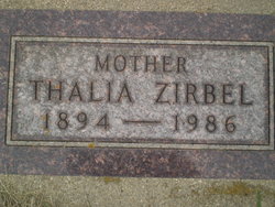
Thalia Roselda Larson Zirbel
| Birth | : | 21 Aug 1894 Lake Mills, Winnebago County, Iowa, USA |
| Death | : | 18 Oct 1986 Milbank, Grant County, South Dakota, USA |
| Burial | : | Saint Mary's Churchyard, Creeting St Mary, Mid Suffolk District, England |
| Coordinate | : | 52.1686000, 1.0591500 |
| Plot | : | Block 2, Lot 27, Grave 7 |
| Inscription | : | "Mother" |
| Description | : | Parents listed as Mr/Mrs L M Larson (Lars M Larson and Anna Emelia Bakken) Married Emil Zirbel 03 Jun 1917 at South Shore, SD |
frequently asked questions (FAQ):
-
Where is Thalia Roselda Larson Zirbel's memorial?
Thalia Roselda Larson Zirbel's memorial is located at: Saint Mary's Churchyard, Creeting St Mary, Mid Suffolk District, England.
-
When did Thalia Roselda Larson Zirbel death?
Thalia Roselda Larson Zirbel death on 18 Oct 1986 in Milbank, Grant County, South Dakota, USA
-
Where are the coordinates of the Thalia Roselda Larson Zirbel's memorial?
Latitude: 52.1686000
Longitude: 1.0591500
Family Members:
Spouse
Flowers:
Nearby Cemetories:
1. Saint Mary's Churchyard
Creeting St Mary, Mid Suffolk District, England
Coordinate: 52.1686000, 1.0591500
2. St Peter's Churchyard
Creeting St Peter, Mid Suffolk District, England
Coordinate: 52.1782700, 1.0418800
3. Saint John The Baptist Burial Ground
Needham Market, Mid Suffolk District, England
Coordinate: 52.1533800, 1.0438900
4. St Mary Churchyard
Earl Stonham, Mid Suffolk District, England
Coordinate: 52.1874050, 1.0820890
5. St. Mary's Churchyard
Badley, Mid Suffolk District, England
Coordinate: 52.1629868, 1.0140250
6. St Mary Churchyard
Barking, Mid Suffolk District, England
Coordinate: 52.1416550, 1.0333390
7. St. Andrew's Trust Churchyard
Darmsden, Mid Suffolk District, England
Coordinate: 52.1353327, 1.0588956
8. Stowupland Cemetery
Stowupland, Mid Suffolk District, England
Coordinate: 52.1987389, 1.0293667
9. St Mary Churchyard
Stonham Parva, Mid Suffolk District, England
Coordinate: 52.1990990, 1.0885576
10. Holy Trinity Churchyard
Stowupland, Mid Suffolk District, England
Coordinate: 52.1999210, 1.0306050
11. St Mary Churchyard
Combs, Mid Suffolk District, England
Coordinate: 52.1729800, 0.9979300
12. Combs Parish Cemetery
Combs, Mid Suffolk District, England
Coordinate: 52.1714740, 0.9960700
13. St. Mary's Churchyard
Battisford, Mid Suffolk District, England
Coordinate: 52.1493660, 1.0021970
14. Battisford Cemetery
Battisford, Mid Suffolk District, England
Coordinate: 52.1491260, 1.0013920
15. St. Mary's Churchyard
Coddenham, Mid Suffolk District, England
Coordinate: 52.1445630, 1.1156000
16. United Reformed Church
Stowmarket, Mid Suffolk District, England
Coordinate: 52.1869020, 0.9966670
17. Coddenham Cemetery
Coddenham, Mid Suffolk District, England
Coordinate: 52.1424020, 1.1136650
18. Saint Peter and Saint Mary Churchyard
Stowmarket, Mid Suffolk District, England
Coordinate: 52.1881820, 0.9967600
19. St Mary and St Lambert Churchyard
Stonham Aspal, Mid Suffolk District, England
Coordinate: 52.1926490, 1.1200000
20. Crowfield Church Cemetery
Crowfield, Mid Suffolk District, England
Coordinate: 52.1767090, 1.1320710
21. St. Peter's Churchyard
Baylham, Mid Suffolk District, England
Coordinate: 52.1222000, 1.0695000
22. Old Stowmarket Cemetery
Stowmarket, Mid Suffolk District, England
Coordinate: 52.1948000, 0.9923500
23. New Stowmarket Cemetery
Stowmarket, Mid Suffolk District, England
Coordinate: 52.1948100, 0.9890740
24. Saint Mary Churchyard
Gosbeck, Mid Suffolk District, England
Coordinate: 52.1570000, 1.1426000


