

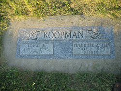
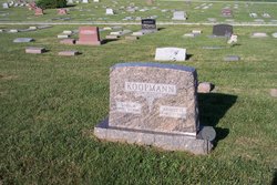
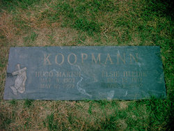
Theodore A “Ted” Koopman
| Birth | : | 1 Jan 1901 Cuming County, Nebraska, USA |
| Death | : | 29 Apr 1970 Rosalie, Thurston County, Nebraska, USA |
| Burial | : | Saint Peters Cemetery, Benoit, Bayfield County, USA |
| Coordinate | : | 46.5236015, -91.0781021 |
| Inscription | : | Father |
frequently asked questions (FAQ):
-
Where is Theodore A “Ted” Koopman's memorial?
Theodore A “Ted” Koopman's memorial is located at: Saint Peters Cemetery, Benoit, Bayfield County, USA.
-
When did Theodore A “Ted” Koopman death?
Theodore A “Ted” Koopman death on 29 Apr 1970 in Rosalie, Thurston County, Nebraska, USA
-
Where are the coordinates of the Theodore A “Ted” Koopman's memorial?
Latitude: 46.5236015
Longitude: -91.0781021
Family Members:
Parent

Spouse
Siblings

Children
Flowers:


Nearby Cemetories:
1. Saint Peters Cemetery
Benoit, Bayfield County, USA
Coordinate: 46.5236015, -91.0781021
2. Benoit Cemetery
Benoit, Bayfield County, USA
Coordinate: 46.5026016, -91.0794983
3. Fish Creek Cemetery
Ino, Bayfield County, USA
Coordinate: 46.5241165, -91.1252823
4. Saints Peter and Paul Catholic Cemetery
Moquah, Bayfield County, USA
Coordinate: 46.5698013, -91.0842972
5. Moquah Cemetery
Moquah, Bayfield County, USA
Coordinate: 46.5701980, -91.0731530
6. Moquah National Cemetery
Moquah, Bayfield County, USA
Coordinate: 46.5702860, -91.0718390
7. Saint Florians Cemetery
Ino, Bayfield County, USA
Coordinate: 46.5161438, -91.1750412
8. Mason Cemetery
Mason, Bayfield County, USA
Coordinate: 46.4401800, -91.0555800
9. B'Nai Israel Cemetery
Ashland, Ashland County, USA
Coordinate: 46.5600014, -90.9116974
10. Delta Cemetery
Delta, Bayfield County, USA
Coordinate: 46.4729500, -91.2398911
11. Saint Agnes Cemetery
Ashland, Ashland County, USA
Coordinate: 46.5614014, -90.9075012
12. Mount Hope Cemetery
Ashland, Ashland County, USA
Coordinate: 46.5621986, -90.9039001
13. Moland Lutheran Church Cemetery
Mason, Bayfield County, USA
Coordinate: 46.4131012, -90.9897995
14. Heitsch Family Burial Plot
Barksdale, Bayfield County, USA
Coordinate: 46.6315661, -90.9560996
15. Church Corner Cemetery
Washburn, Bayfield County, USA
Coordinate: 46.6595000, -90.9889000
16. Saint Anne Catholic Cemetery
Sanborn, Ashland County, USA
Coordinate: 46.4294281, -90.9071426
17. Grand View Cemetery
Grand View, Bayfield County, USA
Coordinate: 46.3650017, -91.1091003
18. Moe Cemetery
Mason, Bayfield County, USA
Coordinate: 46.3789200, -90.9498900
19. Old Apostolic Lutheran Cemetery
Marengo, Ashland County, USA
Coordinate: 46.4408640, -90.8473530
20. Birch Lake Cemetery
Mason, Bayfield County, USA
Coordinate: 46.3569603, -90.9666595
21. Woodland Cemetery
Washburn, Bayfield County, USA
Coordinate: 46.6845100, -90.9049800
22. Calvary Cemetery
Washburn, Bayfield County, USA
Coordinate: 46.6852989, -90.9008026
23. Maple Grove Cemetery
Marengo, Ashland County, USA
Coordinate: 46.3852997, -90.8606033
24. Valley View Cemetery
Iron River, Bayfield County, USA
Coordinate: 46.6227989, -91.3600006