
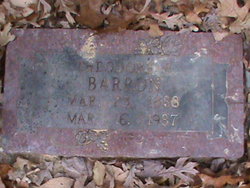
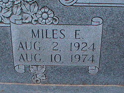
Theodore Franklin Barron
| Birth | : | 23 Mar 1886 Mine La Motte, Madison County, Missouri, USA |
| Death | : | 16 Mar 1987 Desloge, St. Francois County, Missouri, USA |
| Burial | : | New Haven Township Cemetery, New Haven Center, Gratiot County, USA |
| Coordinate | : | 43.2487230, -84.7828580 |
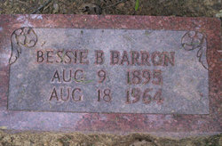
| Description | : | Husband of Bessie Barron Married Aug 30 1914 Missouri Son of John Wesley Barron & Mary Anne Day |
frequently asked questions (FAQ):
-
Where is Theodore Franklin Barron's memorial?
Theodore Franklin Barron's memorial is located at: New Haven Township Cemetery, New Haven Center, Gratiot County, USA.
-
When did Theodore Franklin Barron death?
Theodore Franklin Barron death on 16 Mar 1987 in Desloge, St. Francois County, Missouri, USA
-
Where are the coordinates of the Theodore Franklin Barron's memorial?
Latitude: 43.2487230
Longitude: -84.7828580
Family Members:
Parent

Spouse
Siblings
Children
Flowers:


Nearby Cemetories:
1. New Haven Township Cemetery
New Haven Center, Gratiot County, USA
Coordinate: 43.2487230, -84.7828580
2. Roosa Farm Cemetery
Sumner Township, Gratiot County, USA
Coordinate: 43.2922139, -84.7477728
3. Greenwood Cemetery
Middleton, Gratiot County, USA
Coordinate: 43.2118988, -84.7093964
4. Spencer Cemetery
Crystal, Montcalm County, USA
Coordinate: 43.2883700, -84.8555700
5. Sumner Cemetery
Sumner, Gratiot County, USA
Coordinate: 43.3139000, -84.8242035
6. Mount Calm Mennonite Church Cemetery
Carson City, Montcalm County, USA
Coordinate: 43.1801800, -84.8372300
7. Burke Cemetery
Carson City, Montcalm County, USA
Coordinate: 43.2196999, -84.8852997
8. Carson City Cemetery
Carson City, Montcalm County, USA
Coordinate: 43.1850300, -84.8508400
9. Saint Marys Cemetery
Carson City, Montcalm County, USA
Coordinate: 43.1847600, -84.8508400
10. Klees Cemetery
Montcalm County, USA
Coordinate: 43.3066340, -84.8607230
11. Hayes Road Cemetery
Newark Township, Gratiot County, USA
Coordinate: 43.2196999, -84.6707993
12. Beechler Cemetery
Newark Township, Gratiot County, USA
Coordinate: 43.2481300, -84.6494000
13. Crystal Cemetery
Crystal, Montcalm County, USA
Coordinate: 43.2347470, -84.9158600
14. Wildwood Mennonite Church Cemetery
Perrinton, Gratiot County, USA
Coordinate: 43.1453370, -84.7052760
15. Pritchard Cemetery
Elwell, Gratiot County, USA
Coordinate: 43.3683014, -84.7478027
16. Fritz Cemetery
Ithaca, Gratiot County, USA
Coordinate: 43.2189300, -84.6150000
17. Elm Hall Cemetery
Elm Hall, Gratiot County, USA
Coordinate: 43.3711014, -84.8257980
18. Bloomer Township Cemetery
Carson City, Montcalm County, USA
Coordinate: 43.1516991, -84.8949966
19. Old Fulton Cemetery
Perrinton, Gratiot County, USA
Coordinate: 43.1543300, -84.6620500
20. Fulton Center Cemetery
Perrinton, Gratiot County, USA
Coordinate: 43.1561110, -84.6588890
21. Ferris Center Cemetery
Vestaburg, Montcalm County, USA
Coordinate: 43.3438988, -84.9060974
22. Ithaca Cemetery
Ithaca, Gratiot County, USA
Coordinate: 43.2934710, -84.6125580
23. Vickeryville Old Order Mennonite Church Cemetery
Vickeryville, Montcalm County, USA
Coordinate: 43.1734880, -84.9342820
24. Payne Cemetery
Fulton Township, Gratiot County, USA
Coordinate: 43.1204400, -84.7084800