
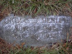
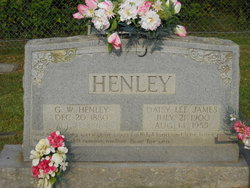
Thomas Jefferson Henley
| Birth | : | 1 Nov 1840 |
| Death | : | 20 Dec 1932 |
| Burial | : | Saint Anne Roman Catholic Cemetery, Sainte-Anne-de-Kent, Kent County, Canada |
| Coordinate | : | 46.5509000, -64.7738340 |
frequently asked questions (FAQ):
-
Where is Thomas Jefferson Henley's memorial?
Thomas Jefferson Henley's memorial is located at: Saint Anne Roman Catholic Cemetery, Sainte-Anne-de-Kent, Kent County, Canada.
-
When did Thomas Jefferson Henley death?
Thomas Jefferson Henley death on 20 Dec 1932 in
-
Where are the coordinates of the Thomas Jefferson Henley's memorial?
Latitude: 46.5509000
Longitude: -64.7738340
Family Members:
Spouse
Children
Flowers:


Nearby Cemetories:
1. Saint Anne Roman Catholic Cemetery
Sainte-Anne-de-Kent, Kent County, Canada
Coordinate: 46.5509000, -64.7738340
2. Old MacIntosh Hill Burial Ground
Kent County, Canada
Coordinate: 46.5031240, -64.7459570
3. (New) Bouctouche Roman Catholic Cemetery
Bouctouche, Kent County, Canada
Coordinate: 46.5104850, -64.6827398
4. Galloway Cemetery
West Galloway, Kent County, Canada
Coordinate: 46.6124320, -64.8520750
5. Saint Jean Baptiste Roman Catholic Cemetery
Bouctouche, Kent County, Canada
Coordinate: 46.4798300, -64.6968100
6. St. Lawrence Anglican Church Cemetery
Bouctouche, Kent County, Canada
Coordinate: 46.4678379, -64.7127546
7. Saint Antoine de Padoue
Richibucto, Kent County, Canada
Coordinate: 46.6568030, -64.7537160
8. Kingdom Hall of Jehovah's Witnesses Cemetery
West Branch, Kent County, Canada
Coordinate: 46.5497546, -64.9345299
9. Chapel Point Cemetery
Richibucto, Kent County, Canada
Coordinate: 46.5966300, -64.9202300
10. Immaculate Conception Roman Catholic Cemetery
Rexton, Kent County, Canada
Coordinate: 46.6400100, -64.8712200
11. Methodist Point Cemetery
Rexton, Kent County, Canada
Coordinate: 46.6042300, -64.9165060
12. Saint Andrew's United Church Cemetery
Rexton, Kent County, Canada
Coordinate: 46.6478700, -64.8724000
13. Hillside Cemetery
McKees Mills, Kent County, Canada
Coordinate: 46.4369000, -64.7202300
14. West Branch Presbyterian Cemetery
West Branch, Kent County, Canada
Coordinate: 46.5410340, -64.9480820
15. Saint John's United Church Cemetery
West Branch, Kent County, Canada
Coordinate: 46.5339660, -64.9571180
16. Richibucto Protestant Cemetery
Richibucto, Kent County, Canada
Coordinate: 46.6730300, -64.8677700
17. Sainte-Marie-de-Kent Cemetery
Sainte-Marie-de-Kent, Kent County, Canada
Coordinate: 46.4147570, -64.8287280
18. Woodlawn Cemetery
McKees Mills, Kent County, Canada
Coordinate: 46.4129800, -64.7266100
19. Saint Anne's Roman Catholic Cemetery
Big Cove, Kent County, Canada
Coordinate: 46.5854736, -64.9864107
20. Saint Louis de Gonzague
Richibucto, Kent County, Canada
Coordinate: 46.6882680, -64.8624160
21. Saint-Norbert Parish Cemetery
Saint-Norbert, Kent County, Canada
Coordinate: 46.4662200, -64.9683100
22. Aldouane Roman Catholic Cemetery
Aldouane, Kent County, Canada
Coordinate: 46.7098670, -64.8985700
23. St. Charles Roman Catholic Cemetery
Saint-Charles, Kent County, Canada
Coordinate: 46.6689480, -64.9729100
24. Coates Mills United Church Cemetery
Coates Mills, Kent County, Canada
Coordinate: 46.3731000, -64.8706940