
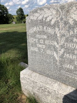

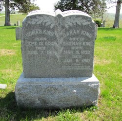
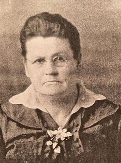
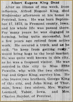
Thomas King
| Birth | : | 13 Sep 1833 Cambridgeshire, England |
| Death | : | 7 Aug 1911 Percival, Fremont County, Iowa, USA |
| Burial | : | St Peter and St Paul Churchyard, Ringwood, New Forest District, England |
| Coordinate | : | 50.8475390, -1.7950970 |
| Plot | : | R18 |
| Description | : | Thomas was baptised 14 Oct 1832 in Exning, Suffolk. His date of birth was probably 13 Sep 1832, not 1833 as per the headstone. |
frequently asked questions (FAQ):
-
Where is Thomas King's memorial?
Thomas King's memorial is located at: St Peter and St Paul Churchyard, Ringwood, New Forest District, England.
-
When did Thomas King death?
Thomas King death on 7 Aug 1911 in Percival, Fremont County, Iowa, USA
-
Where are the coordinates of the Thomas King's memorial?
Latitude: 50.8475390
Longitude: -1.7950970
Family Members:
Parent
Spouse
Siblings
Children

Flowers:


Nearby Cemetories:
1. St Peter and St Paul Churchyard
Ringwood, New Forest District, England
Coordinate: 50.8475390, -1.7950970
2. Ringwood Cemetery
Ringwood, New Forest District, England
Coordinate: 50.8433300, -1.7821000
3. Poulner Baptist Chapelyard
Ringwood, New Forest District, England
Coordinate: 50.8582700, -1.7590100
4. St Mary and All Saints Churchyard
Ellingham, New Forest District, England
Coordinate: 50.8742140, -1.7964340
5. St. Martin's Churchyard
Ibsley, New Forest District, England
Coordinate: 50.8835000, -1.7893100
6. St Paul Churchyard
Bisterne, New Forest District, England
Coordinate: 50.8102700, -1.7900000
7. Verwood Cemetery
Verwood, East Dorset District, England
Coordinate: 50.8709100, -1.8510700
8. All Saints Churchyard
Harbridge, New Forest District, England
Coordinate: 50.8905600, -1.7956500
9. West Moors Cemetery
West Moors, East Dorset District, England
Coordinate: 50.8158410, -1.8737500
10. St. Michael and All Angels Churchyard
Verwood, East Dorset District, England
Coordinate: 50.8778860, -1.8808700
11. St. Mary the Virgin Church Cemetery
West Moors, East Dorset District, England
Coordinate: 50.8299273, -1.8895069
12. St John the Baptist Churchyard
Burley, New Forest District, England
Coordinate: 50.8274700, -1.6971500
13. Burley Chapel Cemetery
Burley, New Forest District, England
Coordinate: 50.8313000, -1.6930000
14. Holy Ascension Churchyard
Hyde, New Forest District, England
Coordinate: 50.9115300, -1.7660300
15. All Saints Churchyard
Thorney Hill, New Forest District, England
Coordinate: 50.7966900, -1.7215500
16. Sopley Cemetery
Sopley, New Forest District, England
Coordinate: 50.7774250, -1.7847770
17. Alderholt Chapelyard
Alderholt, North Dorset District, England
Coordinate: 50.9164000, -1.8259524
18. Stuckton Congregational Chapelyard
New Forest District, England
Coordinate: 50.9182358, -1.7740048
19. St. James' Churchyard
Alderholt, North Dorset District, England
Coordinate: 50.9127470, -1.8525560
20. St. Mary the Virgin Churchyard
Fordingbridge, New Forest District, England
Coordinate: 50.9236200, -1.7946300
21. Fordingbridge Methodist Church
Fordingbridge, New Forest District, England
Coordinate: 50.9251012, -1.7948375
22. Fordingbridge Cemetery
Fordingbridge, New Forest District, England
Coordinate: 50.9253570, -1.7818480
23. St Michael and All Angels Churchyard
Sopley, New Forest District, England
Coordinate: 50.7697400, -1.7794200
24. St Mary Churchyard
Ferndown, East Dorset District, England
Coordinate: 50.7997260, -1.8935890