
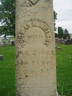
Thomas Miles Wright
| Birth | : | 3 Sep 1775 East Hampton, Middlesex County, Connecticut, USA |
| Death | : | 7 Feb 1864 Maquoketa, Jackson County, Iowa, USA |
| Burial | : | Knights Landing Cemetery, Knights Landing, Yolo County, USA |
| Coordinate | : | 38.7904530, -121.7284190 |
| Description | : | Thomas Wright was born in Chatham, (now East Hampton), Middlesex, Connecticut on September 3, 1775. He was the son of Thomas Wright, who was a seafarer, and his wife Anna Creemer. He was only two years old when his father died, possibly at sea. According to later sources, he removed to Gill, Franklin County, Massachusetts as a young man, where he married Eliza Smead. Unfortunately, no record exists in Franklin County of Thomas. In 1800, Thomas & Eliza moved to Bolton, Warren County, New York. For some years he was involved in farming, and later he built a woolen mill... Read More |
frequently asked questions (FAQ):
-
Where is Thomas Miles Wright's memorial?
Thomas Miles Wright's memorial is located at: Knights Landing Cemetery, Knights Landing, Yolo County, USA.
-
When did Thomas Miles Wright death?
Thomas Miles Wright death on 7 Feb 1864 in Maquoketa, Jackson County, Iowa, USA
-
Where are the coordinates of the Thomas Miles Wright's memorial?
Latitude: 38.7904530
Longitude: -121.7284190
Family Members:
Parent
Spouse
Children

Flowers:


Nearby Cemetories:
1. Knights Landing Cemetery
Knights Landing, Yolo County, USA
Coordinate: 38.7904530, -121.7284190
2. Marys Cemetery
Yolo, Yolo County, USA
Coordinate: 38.7635994, -121.8032990
3. Cacheville Cemetery
Yolo, Yolo County, USA
Coordinate: 38.7378300, -121.8090200
4. Woodland Cemetery
Woodland, Yolo County, USA
Coordinate: 38.6711006, -121.7846985
5. Saint Joseph Cemetery
Woodland, Yolo County, USA
Coordinate: 38.6694400, -121.7842120
6. Monument Hill Memorial Park
Woodland, Yolo County, USA
Coordinate: 38.6781020, -121.8566400
7. Pleasant Grove Cemetery
Pleasant Grove, Sutter County, USA
Coordinate: 38.8230000, -121.5206900
8. Nicolaus Cemetery
Nicolaus, Sutter County, USA
Coordinate: 38.8958015, -121.5639038
9. Gordon Family Cemetery
Esparto, Yolo County, USA
Coordinate: 38.6966060, -121.9151540
10. Fairview Cemetery
Rio Oso, Sutter County, USA
Coordinate: 38.9389000, -121.5250015
11. Hunter Cemetery
Sutter County, USA
Coordinate: 39.0118080, -121.8050590
12. Cottonwood Cemetery
Winters, Yolo County, USA
Coordinate: 38.6500015, -121.9677963
13. Davis Cemetery
Davis, Yolo County, USA
Coordinate: 38.5550003, -121.7260971
14. Episcopal Church of Saint Martin Columbarium
Davis, Yolo County, USA
Coordinate: 38.5488870, -121.7611850
15. Johns Cemetery
Colusa County, USA
Coordinate: 38.9571991, -121.9689026
16. Capay Cemetery
Esparto, Yolo County, USA
Coordinate: 38.6944008, -122.0447006
17. Sunset Lawn Chapel of the Chimes Memorial Park
Sacramento, Sacramento County, USA
Coordinate: 38.6514816, -121.4384842
18. Union Cemetery
Roseville, Placer County, USA
Coordinate: 38.7302600, -121.3924200
19. Holy Ascension Russian Orthodox Cemetery
Sacramento, Sacramento County, USA
Coordinate: 38.5846212, -121.4936736
20. Corbin Cemetery
Esparto, Yolo County, USA
Coordinate: 38.6240710, -122.0105040
21. California State Capitol
Sacramento, Sacramento County, USA
Coordinate: 38.5760994, -121.4931488
22. National Shrine of Our Lady of Guadalupe Crypt
Sacramento, Sacramento County, USA
Coordinate: 38.5704800, -121.5014400
23. Sacramento City Cemetery
Sacramento, Sacramento County, USA
Coordinate: 38.5636864, -121.5009537
24. School House Park Cemetery
Roseville, Placer County, USA
Coordinate: 38.7893180, -121.3578670