
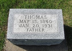
Thomas Thornton
| Birth | : | 15 May 1840 County Mayo, Ireland |
| Death | : | 20 Jan 1931 Black Hawk County, Iowa, USA |
| Burial | : | New Row Methodist Church, Blackburn with Darwen Unitary Authority, England |
| Coordinate | : | 53.7208950, -2.5023720 |
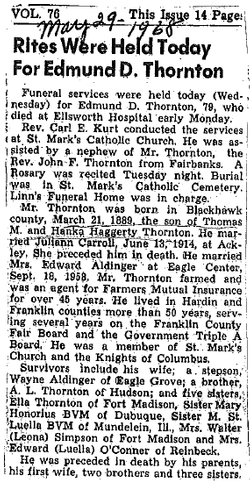
| Description | : | Traer Star Clipper, Friday , January 23, 1931 page 9 Father of Sixteen Is Taken by Death at Home Near Here Thomas Thornton, 90, Succumbs to Illness of Pneumonia—Had Enjoyed Good Health WAS EARLY PIONEER OF BLESSING NEIGHBORHOOD Lived on the Same Farm More Than Sixty Years—Funeral Held Yesterday at Church Thomas Thornton, 90, pioneer resident of the Blessing community nine miles north of Traer, died about 4:30 p. m. Tuesday at his home just north of the Blessing church. Despite his advanced age he had always enjoyed good health and was surprisingly... Read More |
frequently asked questions (FAQ):
-
Where is Thomas Thornton's memorial?
Thomas Thornton's memorial is located at: New Row Methodist Church, Blackburn with Darwen Unitary Authority, England.
-
When did Thomas Thornton death?
Thomas Thornton death on 20 Jan 1931 in Black Hawk County, Iowa, USA
-
Where are the coordinates of the Thomas Thornton's memorial?
Latitude: 53.7208950
Longitude: -2.5023720
Family Members:
Spouse

Children

Flowers:


Nearby Cemetories:
1. New Row Methodist Church
Blackburn with Darwen Unitary Authority, England
Coordinate: 53.7208950, -2.5023720
2. St Stephen Churchyard
Tockholes, Blackburn with Darwen Unitary Authority, England
Coordinate: 53.7058350, -2.5169320
3. St James Churchyard
Lower Darwen, Blackburn with Darwen Unitary Authority, England
Coordinate: 53.7245510, -2.4634700
4. St. Peter's Churchyard
Blackburn, Blackburn with Darwen Unitary Authority, England
Coordinate: 53.7448110, -2.4865070
5. Independent Chapel Churchyard
Blackburn, Blackburn with Darwen Unitary Authority, England
Coordinate: 53.7454960, -2.4864460
6. Pleasington Cemetery and Crematorium
Blackburn, Blackburn with Darwen Unitary Authority, England
Coordinate: 53.7388880, -2.5368710
7. Wesleyan Methodist Chapel Chapelyard
Blackburn, Blackburn with Darwen Unitary Authority, England
Coordinate: 53.7464910, -2.4848380
8. Pleasington Priory
Pleasington, Blackburn with Darwen Unitary Authority, England
Coordinate: 53.7348590, -2.5433060
9. Blackburn Cathedral
Blackburn, Blackburn with Darwen Unitary Authority, England
Coordinate: 53.7472960, -2.4820020
10. St Paul's
Blackburn, Blackburn with Darwen Unitary Authority, England
Coordinate: 53.7491222, -2.4891266
11. Mount St Presbyterian Chapelyard
Blackburn, Blackburn with Darwen Unitary Authority, England
Coordinate: 53.7478000, -2.4775000
12. St Peters Churchyard
Darwen, Blackburn with Darwen Unitary Authority, England
Coordinate: 53.6955520, -2.4648090
13. Holy Trinity Church
Blackburn with Darwen Unitary Authority, England
Coordinate: 53.7511727, -2.4747178
14. St Alban's Churchyard
Blackburn, Blackburn with Darwen Unitary Authority, England
Coordinate: 53.7530090, -2.4748540
15. St Paul's Churchyard
Withnell, Chorley Borough, England
Coordinate: 53.6970740, -2.5592150
16. St. Paul's Churchyard
Darwen, Blackburn with Darwen Unitary Authority, England
Coordinate: 53.6979270, -2.4318640
17. Blackburn Cemetery
Blackburn, Blackburn with Darwen Unitary Authority, England
Coordinate: 53.7662430, -2.4726050
18. Holy Trinity Churchyard
Hoghton, Chorley Borough, England
Coordinate: 53.7279300, -2.5848550
19. Darwen Cemetery
Darwen, Blackburn with Darwen Unitary Authority, England
Coordinate: 53.6781400, -2.4598300
20. Darwen Eastern Cemetery
Darwen, Blackburn with Darwen Unitary Authority, England
Coordinate: 53.6769300, -2.4547700
21. St. Josephs Roman Catholic Churchyard
Brindle, Chorley Borough, England
Coordinate: 53.7350780, -2.5880640
22. Pickup Bank Congregational Chapel
Pickup Bank, Blackburn with Darwen Unitary Authority, England
Coordinate: 53.7012440, -2.4164220
23. St. Mary's Churchyard
Mellor, Ribble Valley Borough, England
Coordinate: 53.7728600, -2.5312400
24. Mellor Methodist Churchyard
Blackburn, Blackburn with Darwen Unitary Authority, England
Coordinate: 53.7742950, -2.5255060