

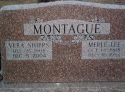
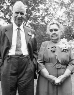
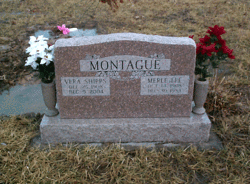
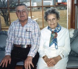
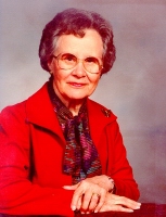
Vera Ellen Shipps Montague
| Birth | : | 25 Dec 1908 Franklin County, Kansas, USA |
| Death | : | 5 Dec 2004 Ottawa, Franklin County, Kansas, USA |
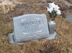
| Burial | : | Woodlawn Cemetery, Pomona, Franklin County, USA |
| Coordinate | : | 38.6100006, -95.4681015 |
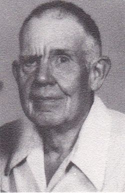
| Description | : | She was born to Joseph Turner and Ruby Pearl (Van Briggle) Shipps in rural Franklin County. She attended Union Center Grade School and Appanoose High School. She married Merle Lee Montague on Jan. 3, 1929, at the Methodist parsonage in Pomona. He died Dec. 31, 1984. She helped her husband farm and worked as a cook for West Franklin Unified School District 287 for several years. She was a member of the Pomona United Methodist Church, the Pomona United Methodist Women, the Rebekah Lodge, Pomona; and served on the Silver Lake School Board. She was a graduate... Read More |
frequently asked questions (FAQ):
-
Where is Vera Ellen Shipps Montague's memorial?
Vera Ellen Shipps Montague's memorial is located at: Woodlawn Cemetery, Pomona, Franklin County, USA.
-
When did Vera Ellen Shipps Montague death?
Vera Ellen Shipps Montague death on 5 Dec 2004 in Ottawa, Franklin County, Kansas, USA
-
Where are the coordinates of the Vera Ellen Shipps Montague's memorial?
Latitude: 38.6100006
Longitude: -95.4681015
Family Members:
Parent

Spouse
Siblings
Children
Flowers:


Nearby Cemetories:
1. Woodlawn Cemetery
Pomona, Franklin County, USA
Coordinate: 38.6100006, -95.4681015
2. Nightingale Farm Cemetery
Pomona, Franklin County, USA
Coordinate: 38.5815300, -95.4409300
3. Eastview Cemetery
Quenemo, Osage County, USA
Coordinate: 38.6081009, -95.5235977
4. Greenwood Cemetery
Franklin County, USA
Coordinate: 38.5781700, -95.4145900
5. Oak Hill Cemetery
Quenemo, Osage County, USA
Coordinate: 38.5918999, -95.5333023
6. Pleasant Ridge Cemetery
Osage County, USA
Coordinate: 38.6492004, -95.5271988
7. Central Cemetery
Pomona, Franklin County, USA
Coordinate: 38.5352936, -95.4522629
8. Parkinson Cemetery
Franklin County, USA
Coordinate: 38.6479500, -95.3804800
9. Chippewa Hills Cemetery
Ottawa, Franklin County, USA
Coordinate: 38.5913100, -95.3649200
10. Humphreys Cemetery
Quenemo, Osage County, USA
Coordinate: 38.5398300, -95.5316200
11. Munsee Indian Cemetery
Ottawa, Franklin County, USA
Coordinate: 38.5677986, -95.3688965
12. Salt Creek Cemetery
Osage County, USA
Coordinate: 38.6164100, -95.5875300
13. Dean Cemetery
Pomona, Franklin County, USA
Coordinate: 38.7038994, -95.4781036
14. Mount Pleasant Cemetery
Homewood, Franklin County, USA
Coordinate: 38.5397000, -95.3787700
15. Lamont Hill Cemetery
Vassar, Osage County, USA
Coordinate: 38.6392400, -95.6004600
16. Antioch Cemetery
Homewood, Franklin County, USA
Coordinate: 38.5388985, -95.3593979
17. Evergreen Mound Cemetery
Ottawa, Franklin County, USA
Coordinate: 38.6357994, -95.3225021
18. Foster Cemetery
Ottawa, Franklin County, USA
Coordinate: 38.6651390, -95.3324460
19. Vassar Cemetery
Osage County, USA
Coordinate: 38.6408005, -95.6192017
20. Kaub Cemetery
Centropolis, Franklin County, USA
Coordinate: 38.7172012, -95.3899994
21. Pleasant Hill Cemetery
Centropolis, Franklin County, USA
Coordinate: 38.7243996, -95.4021988
22. Appanoose Cemetery
Globe, Douglas County, USA
Coordinate: 38.7392006, -95.4642029
23. Pleasant View Cemetery
Melvern, Osage County, USA
Coordinate: 38.5064011, -95.5727997
24. Douglas Caldwell Cemetery
Franklin County, USA
Coordinate: 38.4956900, -95.3810400