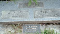
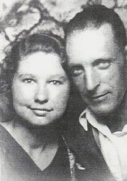
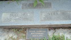
Vera Rosie Hemenway Lander
| Birth | : | 14 Feb 1918 Redding, Shasta County, California, USA |
| Death | : | 6 Nov 1978 Tehama, Tehama County, California, USA |
| Burial | : | Lytham Park Cemetery and Crematorium, Lytham Saint Annes, Fylde Borough, England |
| Coordinate | : | 53.7534410, -2.9825790 |
| Plot | : | Lander Family Plot |
| Description | : | Vera Rosie Hemenway was born to Claudius Galen Hemenway and Alice Lillian (Stowe) Hemenway on February 14, 1918 in Redding, California. Vera married Bud Lander on Oct. 19, 1936 in Red Bluff, California. They had five sons and remained in Red Bluff their entire married life. |
frequently asked questions (FAQ):
-
Where is Vera Rosie Hemenway Lander's memorial?
Vera Rosie Hemenway Lander's memorial is located at: Lytham Park Cemetery and Crematorium, Lytham Saint Annes, Fylde Borough, England.
-
When did Vera Rosie Hemenway Lander death?
Vera Rosie Hemenway Lander death on 6 Nov 1978 in Tehama, Tehama County, California, USA
-
Where are the coordinates of the Vera Rosie Hemenway Lander's memorial?
Latitude: 53.7534410
Longitude: -2.9825790
Family Members:
Spouse
Siblings
Flowers:
Nearby Cemetories:
1. Lytham Park Cemetery and Crematorium
Lytham Saint Annes, Fylde Borough, England
Coordinate: 53.7534410, -2.9825790
2. St. Cuthbert Churchyard
Lytham Saint Annes, Fylde Borough, England
Coordinate: 53.7376560, -2.9761270
3. Saltcoates Roman Catholic Cemetery
Lytham Saint Annes, Fylde Borough, England
Coordinate: 53.7463000, -2.9448940
4. St John the Divine
Lytham Saint Annes, Fylde Borough, England
Coordinate: 53.7367060, -2.9548070
5. St Anne's Parish Church
St Annes, Fylde Borough, England
Coordinate: 53.7565230, -3.0227100
6. St Nicholas Churchyard
Wrea Green, Fylde Borough, England
Coordinate: 53.7772420, -2.9156380
7. St. Anne's Roman Catholic Churchyard
Westby, Fylde Borough, England
Coordinate: 53.7876590, -2.9247000
8. Marton Burial Ground
Great Marton, Blackpool Unitary Authority, England
Coordinate: 53.8030870, -3.0108350
9. Parish Church of St. Paul
Warton, Fylde Borough, England
Coordinate: 53.7502621, -2.8932641
10. St Michael Churchyard
Weeton, Fylde Borough, England
Coordinate: 53.7995380, -2.9358020
11. Saint Paul Churchyard
Great Marton, Blackpool Unitary Authority, England
Coordinate: 53.8053220, -3.0268330
12. Holy Trinity Churchyard
Blackpool, Blackpool Unitary Authority, England
Coordinate: 53.7962949, -3.0536214
13. Saint John the Evangelist Churchyard
Kirkham, Fylde Borough, England
Coordinate: 53.7808000, -2.8873870
14. Carlton Cemetery& Crematorium
Blackpool, Blackpool Unitary Authority, England
Coordinate: 53.8095921, -3.0364920
15. Holy Trinity Churchyard
Freckleton, Fylde Borough, England
Coordinate: 53.7543090, -2.8669130
16. Christ Church Churchyard
Wesham, Fylde Borough, England
Coordinate: 53.7905000, -2.8845600
17. Saint Joseph's Roman Catholic Church
Wesham, Fylde Borough, England
Coordinate: 53.7928600, -2.8871800
18. Zion Chapel Cemetery
Kirkham, Fylde Borough, England
Coordinate: 53.7814380, -2.8721260
19. St Michael Churchyard
Kirkham, Fylde Borough, England
Coordinate: 53.7843570, -2.8709520
20. Quakers Wood Burial Ground
Freckleton, Fylde Borough, England
Coordinate: 53.7652227, -2.8601674
21. St John the Evangelist Churchyard
Blackpool, Blackpool Unitary Authority, England
Coordinate: 53.8182303, -3.0508197
22. Layton Cemetery
Blackpool, Blackpool Unitary Authority, England
Coordinate: 53.8273740, -3.0328240
23. St. Stephen's Churchyard
North Meols, West Lancashire District, England
Coordinate: 53.6813720, -2.9248140
24. Blackpool Jewish Cemetery
Blackpool, Blackpool Unitary Authority, England
Coordinate: 53.8287397, -3.0311753


