
| Birth | : | 24 Jul 1904 Council Grove, Morris County, Kansas, USA |
| Death | : | 15 Apr 1992 Kansas, USA |
| Burial | : | Saint Johns Catholic Cemetery, Independence, Buchanan County, USA |
| Coordinate | : | 42.4822006, -91.8957977 |
| Plot | : | Section 8/Lot 244 |
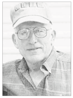
| Description | : | Graveside services for Vere Layton Blankley, 87, Council Grove, will be Saturday afternoon at 2:00 o'clock at the Greenwood Cemetery here. He will lie in state at the Kendall Funeral Chapel today and until 1:00 p.m. Saturday. Mr. Blankley, who died, April 15, 1992, at the Morris County Hospital, was born June 24, 1904, at Marion, son of Hiram and Louisa Browning Blankley. He had lived in Morris County most of his life. He had been a farmer and then worked for Beech Aircraft at Delavan. After retiring from Beech, he became self employed, owning and operating his own trash route in Council... Read More |
frequently asked questions (FAQ):
-
Where is Vere Layton Blankley's memorial?
Vere Layton Blankley's memorial is located at: Saint Johns Catholic Cemetery, Independence, Buchanan County, USA.
-
When did Vere Layton Blankley death?
Vere Layton Blankley death on 15 Apr 1992 in Kansas, USA
-
Where are the coordinates of the Vere Layton Blankley's memorial?
Latitude: 42.4822006
Longitude: -91.8957977
Family Members:
Parent

Spouse
Siblings
Children
Flowers:


Nearby Cemetories:
1. Saint Johns Catholic Cemetery
Independence, Buchanan County, USA
Coordinate: 42.4822006, -91.8957977
2. Oakwood Cemetery
Independence, Buchanan County, USA
Coordinate: 42.4627991, -91.8927994
3. West Haven Cemetery
Independence, Buchanan County, USA
Coordinate: 42.4588678, -91.8986696
4. Buchanan County Poor Farm Cemetery
Independence, Buchanan County, USA
Coordinate: 42.4871560, -91.8647280
5. Mount Hope Cemetery
Independence, Buchanan County, USA
Coordinate: 42.4571991, -91.8914032
6. Buchanan County Home Cemetery
Independence, Buchanan County, USA
Coordinate: 42.4903050, -91.8596350
7. Wilson Cemetery
Independence, Buchanan County, USA
Coordinate: 42.4658012, -91.8516998
8. State Hospital Cemetery
Independence, Buchanan County, USA
Coordinate: 42.4455986, -91.9253006
9. Otterville Cemetery
Buchanan County, USA
Coordinate: 42.5158005, -91.9392014
10. Pine Creek Cemetery
Quasqueton, Buchanan County, USA
Coordinate: 42.4172400, -91.7867200
11. Littleton Cemetery
Littleton, Buchanan County, USA
Coordinate: 42.5338593, -92.0179520
12. Cedar Crest Cemetery
Jesup, Buchanan County, USA
Coordinate: 42.4782982, -92.0406036
13. Saint Athanasius Cemetery
Jesup, Buchanan County, USA
Coordinate: 42.4761009, -92.0421982
14. Rowley Cemetery
Rowley, Buchanan County, USA
Coordinate: 42.3716621, -91.8530655
15. Fairview Cemetery
Winthrop, Buchanan County, USA
Coordinate: 42.4692001, -91.7407990
16. Payne Cemetery
Winthrop, Buchanan County, USA
Coordinate: 42.5203018, -91.7453003
17. Saint Patricks Cemetery
Winthrop, Buchanan County, USA
Coordinate: 42.4653015, -91.7328033
18. Hickory Grove Cemetery
Quasqueton, Buchanan County, USA
Coordinate: 42.4207598, -91.7534684
19. Fontana Cemetery
Hazleton, Buchanan County, USA
Coordinate: 42.6046982, -91.9052963
20. Fremont Township Cemetery
Winthrop, Buchanan County, USA
Coordinate: 42.5046997, -91.7264023
21. Amish Cemetery
Buchanan County, USA
Coordinate: 42.5689011, -92.0224991
22. Quasqueton Cemetery
Quasqueton, Buchanan County, USA
Coordinate: 42.3994370, -91.7621231
23. Byron Township Cemetery
Buchanan County, USA
Coordinate: 42.5271988, -91.7275009
24. Saint Marys Cemetery
Hazleton, Buchanan County, USA
Coordinate: 42.6164017, -91.8983002