
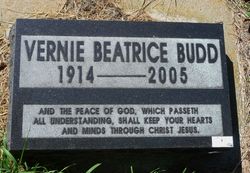
Vernie Beatrice Warden Budd
| Birth | : | 7 May 1914 Strathmore Census Division, Alberta, Canada |
| Death | : | 22 Oct 2005 Lethbridge, Lethbridge Census Division, Alberta, Canada |
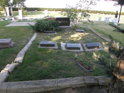
| Burial | : | Vulcan Cemetery, Vulcan, Strathmore Census Division, Canada |
| Coordinate | : | 50.4032200, -113.2774100 |
| Plot | : | Block 2 Lot 165 Grave C |
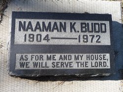
| Description | : | VULCAN FUNERAL HOME - OBIT EXCERPTS Vernie Beatrice (Warden) Budd passed away peacefully at Lethbridge, Alberta on the 22nd of October, 2005 at the generous age of 91 years. Vernie was born at Reid Hill, Alberta on the 7th of May, 1914. She grew up in an era of technological change, global depression and world wars, all the while nurtured in a large family dedicated to Christ, loving kindness to all, and a house full of music. Vernie attended school at Reid Hill, riding her horse there every day. She spent her high school years at Vulcan, she met Naaman Budd in... Read More |
frequently asked questions (FAQ):
-
Where is Vernie Beatrice Warden Budd's memorial?
Vernie Beatrice Warden Budd's memorial is located at: Vulcan Cemetery, Vulcan, Strathmore Census Division, Canada.
-
When did Vernie Beatrice Warden Budd death?
Vernie Beatrice Warden Budd death on 22 Oct 2005 in Lethbridge, Lethbridge Census Division, Alberta, Canada
-
Where are the coordinates of the Vernie Beatrice Warden Budd's memorial?
Latitude: 50.4032200
Longitude: -113.2774100
Family Members:
Parent
Spouse
Siblings

Flowers:


Nearby Cemetories:
1. Vulcan Cemetery
Vulcan, Strathmore Census Division, Canada
Coordinate: 50.4032200, -113.2774100
2. Highland Cemetery
Vulcan, Strathmore Census Division, Canada
Coordinate: 50.4845700, -113.2659100
3. Cleverville Cemetery
Champion, Strathmore Census Division, Canada
Coordinate: 50.2736100, -113.1661700
4. Reid Hill Cemetery
Vulcan, Strathmore Census Division, Canada
Coordinate: 50.3974000, -113.0295500
5. Brant Cemetery
Brant, Strathmore Census Division, Canada
Coordinate: 50.5067400, -113.5068000
6. Fath Hill Catholic Cemetery
Champion, Strathmore Census Division, Canada
Coordinate: 50.2153400, -113.2544200
7. Champion Cemetery
Champion, Strathmore Census Division, Canada
Coordinate: 50.2329200, -113.1441800
8. Sharon Cemetery
Brant, Strathmore Census Division, Canada
Coordinate: 50.4555300, -113.5740800
9. Little Bow Hutterite Cemetery
Stavely, Claresholm Census Division, Canada
Coordinate: 50.2142141, -113.3694417
10. Isol Russell Grave
Champion, Strathmore Census Division, Canada
Coordinate: 50.1792300, -113.2102100
11. Alston Cemetery
Vulcan, Strathmore Census Division, Canada
Coordinate: 50.1652820, -113.2450470
12. Arrowwood Hutterite Cemetery
Herronton, Strathmore Census Division, Canada
Coordinate: 50.6368299, -113.4157544
13. High River Hutterite Cemetery
High River, Calgary Census Division, Canada
Coordinate: 50.4816260, -113.6618863
14. Frankburg Cemetery
High River, Calgary Census Division, Canada
Coordinate: 50.5287300, -113.6445850
15. Krasivaya Dolina Cemetery
Queenstown, Strathmore Census Division, Canada
Coordinate: 50.5908100, -112.9593600
16. Carmangay Cemetery
Carmangay, Strathmore Census Division, Canada
Coordinate: 50.1214300, -113.1434300
17. Hope Lutheran Cemetery
Milo, Strathmore Census Division, Canada
Coordinate: 50.6013300, -112.9238900
18. Blackie Cemetery
Blackie, Calgary Census Division, Canada
Coordinate: 50.6084400, -113.6290500
19. St. Cecilia's Roman Catholic Cemetery
Nanton, Claresholm Census Division, Canada
Coordinate: 50.3588000, -113.7591600
20. Nanton Town Cemetery
Nanton, Claresholm Census Division, Canada
Coordinate: 50.3333800, -113.7586100
21. Saint Vincent Roman Catholic Cemetery
Stavely, Claresholm Census Division, Canada
Coordinate: 50.1717670, -113.6409830
22. Shadow Ranch Hutterite Cemetery
Champion, Strathmore Census Division, Canada
Coordinate: 50.1820466, -112.8929664
23. Arrowwood Cemetery
Arrowwood, Strathmore Census Division, Canada
Coordinate: 50.7211418, -113.1209030
24. Stavely Cemetery
Stavely, Claresholm Census Division, Canada
Coordinate: 50.1646700, -113.6625600