
| Birth | : | 15 Feb 1896 Ostrander, Cowlitz County, Washington, USA |
| Death | : | 14 Mar 1989 Longview, Cowlitz County, Washington, USA |
| Burial | : | Crescent Hill Memorial Gardens and Mausoleum, Columbia, Richland County, USA |
| Coordinate | : | 34.0297012, -81.0089035 |
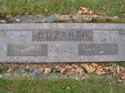
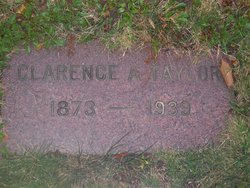
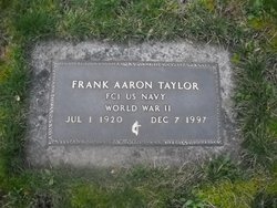
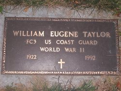
| Description | : | Daughter of John Ralph Bozarth & Sarah Anne Tooley. Married first to Clarence Alfred Taylor. They had 5 sons: Donald, John, Frank, William and Clarence. After Clarence's death she married William Brewer. --------------------------- OBITUARY Veroca A. Brewer Lifelong area resident Veroca A. Brewer of 201 Elm St., Kalama, died March 14 1989 in a Longview nursing home. She was 93. Mrs. Brewer was born Febuary 15, 1896, in Ostrander, Wa. she ws a homemaker and a former member of the American Legion Auxilliary, Woodlond Barracks World War 1 Veterans and Women's Benefit Association Lodge. Surviving are her five son's; John Taylor and William Taylor of... Read More |
frequently asked questions (FAQ):
-
Where is Veroca V Bozarth Brewer's memorial?
Veroca V Bozarth Brewer's memorial is located at: Crescent Hill Memorial Gardens and Mausoleum, Columbia, Richland County, USA.
-
When did Veroca V Bozarth Brewer death?
Veroca V Bozarth Brewer death on 14 Mar 1989 in Longview, Cowlitz County, Washington, USA
-
Where are the coordinates of the Veroca V Bozarth Brewer's memorial?
Latitude: 34.0297012
Longitude: -81.0089035
Family Members:
Parent

Spouse
Siblings
Children
Flowers:


Nearby Cemetories:
1. Crescent Hill Memorial Gardens and Mausoleum
Columbia, Richland County, USA
Coordinate: 34.0297012, -81.0089035
2. Barhamville Cemetery
Columbia, Richland County, USA
Coordinate: 34.0236870, -81.0107570
3. Gunter's Chapel Baptist Church Cemetery
Columbia, Richland County, USA
Coordinate: 34.0394590, -81.0028790
4. Colored Asylum Cemetery
Columbia, Richland County, USA
Coordinate: 34.0244050, -81.0220490
5. Lincoln Cemetery
Columbia, Richland County, USA
Coordinate: 34.0400009, -81.0214005
6. Promised Land Cemetery
Columbia, Richland County, USA
Coordinate: 34.0423830, -80.9960170
7. Saint Lukes Episcopal Church Memorial Garden
Columbia, Richland County, USA
Coordinate: 34.0082060, -81.0180940
8. Antioch Baptist Church Cemetery
Columbia, Richland County, USA
Coordinate: 34.0525790, -81.0114780
9. Pine Ridge Cemetery
Columbia, Richland County, USA
Coordinate: 34.0539017, -81.0124969
10. Alms House Burial Ground
Columbia, Richland County, USA
Coordinate: 34.0314610, -80.9794210
11. Eastminster Presbyterian Church Columbarium
Columbia, Richland County, USA
Coordinate: 34.0079530, -80.9942360
12. Miller Cemetery
Columbia, Richland County, USA
Coordinate: 34.0321999, -81.0391998
13. Geiger Avenue Cemetery
Columbia, Richland County, USA
Coordinate: 34.0228050, -81.0394590
14. Church of the Good Shepherd Memorial Gardens
Columbia, Richland County, USA
Coordinate: 34.0096610, -81.0316160
15. Palmetto Cemetery
Columbia, Richland County, USA
Coordinate: 34.0521785, -81.0290293
16. Ebenezer Lutheran Church Cemetery
Columbia, Richland County, USA
Coordinate: 34.0113680, -81.0361220
17. Mount Pleasant United Methodist Church Cemetery
Columbia, Richland County, USA
Coordinate: 34.0101996, -81.0350037
18. Landrum-Stork Cemetery
Columbia, Richland County, USA
Coordinate: 34.0384820, -80.9745280
19. Bethlehem Bapt. Church Family Life Center Cemetery
Columbia, Richland County, USA
Coordinate: 34.0597440, -81.0124540
20. First Baptist Church Cemetery
Columbia, Richland County, USA
Coordinate: 34.0062460, -81.0321850
21. Dent Cemetery
Columbia, Richland County, USA
Coordinate: 34.0560620, -81.0276490
22. Cook Cemetery
Columbia, Richland County, USA
Coordinate: 34.0497220, -80.9809250
23. First Presbyterian Churchyard
Columbia, Richland County, USA
Coordinate: 34.0041110, -81.0293900
24. Rials Family Cemetery
Forest Acres, Richland County, USA
Coordinate: 34.0401070, -80.9737340