


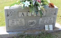
Versie Mae Cherry Allen
| Birth | : | 27 Jun 1932 Union Hill, Clay County, Tennessee, USA |
| Death | : | 16 Jul 2010 Livingston, Overton County, Tennessee, USA |
| Burial | : | Saint Mary's Cemetery, Omaha, Douglas County, USA |
| Coordinate | : | 41.2042007, -95.9646988 |
| Inscription | : | Married 05 Aug 1949 |
| Description | : | Versie Mae Allen , 78 Celina, Tennessee Versie Mae Allen passed away Friday, July 16, 2010 at Livingston Regional Hospital in Livingston, Tennessee. Versie Mae Allen was born June 27, 1932 in Union Hill, Tennessee to the late Kale and Dessie (Price) Cherry. Versie was affiliated with the Church of Christ. She was a homemaker. Her family includes daughters & sons-in-law, Sandra and Eldon Lee of Columbus, Indiana, Shelia and Danny Anderson of Celina, Tennessee & Reba and Joe Boles of Baptist Ridge, Tennessee; grandchildren, Stephanie Wetzel, Michella Lee, Latisha Key, Cassondra Abbott, Jessica Hayes and Tonya Day; great grandchildren, Justin Graves, Joseph Key,... Read More |
frequently asked questions (FAQ):
-
Where is Versie Mae Cherry Allen's memorial?
Versie Mae Cherry Allen's memorial is located at: Saint Mary's Cemetery, Omaha, Douglas County, USA.
-
When did Versie Mae Cherry Allen death?
Versie Mae Cherry Allen death on 16 Jul 2010 in Livingston, Overton County, Tennessee, USA
-
Where are the coordinates of the Versie Mae Cherry Allen's memorial?
Latitude: 41.2042007
Longitude: -95.9646988
Family Members:
Parent
Spouse
Siblings
Children
Flowers:


Nearby Cemetories:
1. Saint Mary's Cemetery
Omaha, Douglas County, USA
Coordinate: 41.2042007, -95.9646988
2. Graceland Park Cemetery
Omaha, Douglas County, USA
Coordinate: 41.2113991, -95.9785995
3. Saint Mary Magdalene Cemetery
Omaha, Douglas County, USA
Coordinate: 41.2039420, -95.9850610
4. Saint Johns Cemetery
Bellevue, Sarpy County, USA
Coordinate: 41.1864014, -95.9682999
5. Laurel Hill Cemetery
Omaha, Douglas County, USA
Coordinate: 41.1918983, -95.9417038
6. Fisher Farm Cemetery
Bellevue, Sarpy County, USA
Coordinate: 41.1727982, -95.9760971
7. Hrabik Cemetery
Bellevue, Sarpy County, USA
Coordinate: 41.1726540, -95.9768200
8. Westlawn-Hillcrest Memorial Park
Omaha, Douglas County, USA
Coordinate: 41.2346992, -95.9966965
9. Douglas County Poor Farm Cemetery
Omaha, Douglas County, USA
Coordinate: 41.2437240, -95.9723480
10. Bohemian Cemetery
Omaha, Douglas County, USA
Coordinate: 41.2388992, -95.9955978
11. First Central Congregational Columbarium
Omaha, Douglas County, USA
Coordinate: 41.2563456, -95.9658365
12. Holy Sepulchre Cemetery
Omaha, Douglas County, USA
Coordinate: 41.2543983, -95.9875031
13. Ak-Sar-Ben Racetrack Grounds
Omaha, Douglas County, USA
Coordinate: 41.2414703, -96.0159607
14. Immanuel Lutheran Church Columbarium
Bellevue, Sarpy County, USA
Coordinate: 41.1602700, -95.9218900
15. Calvary Cemetery
Omaha, Douglas County, USA
Coordinate: 41.2364006, -96.0294037
16. Beth El Cemetery
Ralston, Douglas County, USA
Coordinate: 41.2117004, -96.0428009
17. Trinity Cathedral Columbarium
Omaha, Douglas County, USA
Coordinate: 41.2603900, -95.9393660
18. Resurrection Cemetery
Omaha, Douglas County, USA
Coordinate: 41.2344208, -96.0365448
19. Nash Chapel Crypt
Omaha, Douglas County, USA
Coordinate: 41.2665090, -95.9721790
20. Evergreen Memorial Park Cemetery
Omaha, Douglas County, USA
Coordinate: 41.2393990, -96.0355988
21. Papillion Cemetery
Papillion, Sarpy County, USA
Coordinate: 41.1758003, -96.0410995
22. Church of the Holy Spirit Columbarium
Bellevue, Sarpy County, USA
Coordinate: 41.1475000, -95.9244000
23. Council Point Cemetery
Council Bluffs, Pottawattamie County, USA
Coordinate: 41.2110830, -95.8788610
24. Tunison Cemetery
Bellevue, Sarpy County, USA
Coordinate: 41.1357570, -95.9481150