
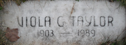
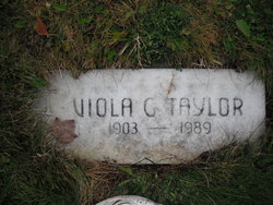
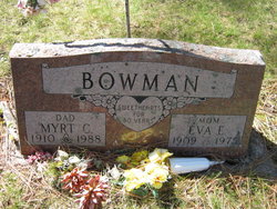
Viola Grace Maxwell Taylor
| Birth | : | 13 Jun 1903 Johnson, Big Stone County, Minnesota, USA |
| Death | : | 9 Feb 1989 Eureka, Lincoln County, Montana, USA |
| Burial | : | Hokitika Municipal Cemetery, Hokitika, Westland District, New Zealand |
| Coordinate | : | -42.7102940, 170.9759800 |
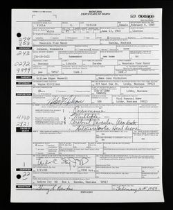
| Description | : | Montana, County Births and Deaths, 1830-2011 Name: Viola G. Taylor [Viola G. Maxwell] Gender: Female Death Age: 85 Birth Date: 13 Jun 1903 Birth Place: Johnson, Minnesota, USA Death Date: 9 Feb 1989 Death Place: Eureka, Lincoln, Montana, USA Father: William Edgar Maxwell Mother: Emma Jane Maxwell Minnesota, Birth Index, 1900-1934 Name: Viola Grace Maxwell Birth Date: 13 Jun 1903 Birth Place: Big Stone, Minnesota Father's Surname: Maxwell Mother's Maiden Name: Nickerson Certificate Number: DC-03719 Social Security Applications and Claims Index,... Read More |
frequently asked questions (FAQ):
-
Where is Viola Grace Maxwell Taylor's memorial?
Viola Grace Maxwell Taylor's memorial is located at: Hokitika Municipal Cemetery, Hokitika, Westland District, New Zealand.
-
When did Viola Grace Maxwell Taylor death?
Viola Grace Maxwell Taylor death on 9 Feb 1989 in Eureka, Lincoln County, Montana, USA
-
Where are the coordinates of the Viola Grace Maxwell Taylor's memorial?
Latitude: -42.7102940
Longitude: 170.9759800
Family Members:
Parent
Spouse
Siblings


Nearby Cemetories:
1. Hokitika Municipal Cemetery
Hokitika, Westland District, New Zealand
Coordinate: -42.7102940, 170.9759800
2. Old Stafford Cemetery
Hokitika, Westland District, New Zealand
Coordinate: -42.6662370, 171.0893140
3. Kumara Cemetery
Kumara, Westland District, New Zealand
Coordinate: -42.6464650, 171.1721970
4. Ross Cemetery
Ross, Westland District, New Zealand
Coordinate: -42.8898440, 170.8226160
5. Gladstone Cemetery
Greymouth, Grey District, New Zealand
Coordinate: -42.5381220, 171.1522540
6. Ross Historic Cemetery
Ross, Westland District, New Zealand
Coordinate: -42.9023200, 170.8113230
7. Greenstone Cemetery
Kumara, Westland District, New Zealand
Coordinate: -42.6361450, 171.2751350
8. Karoro Cemetery
Greymouth, Grey District, New Zealand
Coordinate: -42.4678260, 171.1893800
9. St Pauls Methodist Church (Defunct)
Greymouth, Grey District, New Zealand
Coordinate: -42.4500880, 171.2114610
10. Cobden Cemetery
Greymouth, Grey District, New Zealand
Coordinate: -42.4371700, 171.2019000
11. Stillwater Cemetery
Greymouth, Grey District, New Zealand
Coordinate: -42.4394820, 171.3494380
12. Notown Cemetery
Dobson, Grey District, New Zealand
Coordinate: -42.4514530, 171.4465670
13. Blackball Cemetery
Greymouth, Grey District, New Zealand
Coordinate: -42.3757410, 171.4135760
14. Evans Grave
Arthurs Pass, Selwyn District, New Zealand
Coordinate: -42.7723610, 171.6249940
15. Nelson Creek Cemetery
Ngahere, Grey District, New Zealand
Coordinate: -42.3865620, 171.4595500
16. Barrytown Cemetery
Barrytown, Grey District, New Zealand
Coordinate: -42.2455150, 171.3166710
17. Hari Hari Cemetery
Hari Hari, Westland District, New Zealand
Coordinate: -43.1501430, 170.5576110
18. Ahaura Cemetery
Ahaura, Grey District, New Zealand
Coordinate: -42.3516790, 171.5581700
19. Whataroa Cemetery
Whataroa, Westland District, New Zealand
Coordinate: -43.2530190, 170.3587130
20. Lake Coleridge Cemetery
Lake Coleridge, Selwyn District, New Zealand
Coordinate: -43.3695530, 171.5264300
21. Charleston Catholic Cemetery
Charleston, Buller District, New Zealand
Coordinate: -41.9093390, 171.4359110
22. Nile Hill Cemetery
Charleston, Buller District, New Zealand
Coordinate: -41.8991610, 171.4394080
23. Old Reefton Cemetery
Reefton, Buller District, New Zealand
Coordinate: -42.1115220, 171.8590850
24. Reefton Cemetery
Reefton, Buller District, New Zealand
Coordinate: -42.0856940, 171.8470730