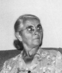
| Birth | : | Jun 1876 Baldwin, Jackson County, Iowa, USA |
| Death | : | 7 Sep 1963 Spencer, Boyd County, Nebraska, USA |
| Burial | : | Union Cemetery, Spencer, Boyd County, USA |
| Coordinate | : | 42.8602982, -98.7018967 |
| Description | : | Virtie was the daughter of David Barney & Sarah A. (Updegraph) Stanton. She married Uriah Lindsey on 21 Feb 1894 in Onawa, IA. They farmed in Woodbury co, Iowa and had daughter Hattie Fern. After Uriah's death, Virtie married Harlan Black on 4 Nov 1897 in Woodbury co, IA. They farmed in Cedar and Holt counties, Nebraska. They moved to Denver, Colo. for a period of time and later had a residence in Spencer, NE. Harlan & Virtie had children: Elsie, Cecil, Garron, Delbert, Albert and Florence I. Burley. |
frequently asked questions (FAQ):
-
Where is Virtie Angeline Stanton Black's memorial?
Virtie Angeline Stanton Black's memorial is located at: Union Cemetery, Spencer, Boyd County, USA.
-
When did Virtie Angeline Stanton Black death?
Virtie Angeline Stanton Black death on 7 Sep 1963 in Spencer, Boyd County, Nebraska, USA
-
Where are the coordinates of the Virtie Angeline Stanton Black's memorial?
Latitude: 42.8602982
Longitude: -98.7018967
Family Members:
Parent
Spouse
Siblings
Children
Flowers:
Nearby Cemetories:
1. Union Cemetery
Spencer, Boyd County, USA
Coordinate: 42.8602982, -98.7018967
2. Saint Marys Cemetery
Spencer, Boyd County, USA
Coordinate: 42.8669014, -98.6980972
3. Devil's Gulch Ranch Cemetery
Spencer, Boyd County, USA
Coordinate: 42.8565316, -98.6871239
4. Bohemian National Cemetery
Spencer, Boyd County, USA
Coordinate: 42.8713989, -98.7127991
5. Old Immanuel Cemetery
Spencer, Boyd County, USA
Coordinate: 42.9006004, -98.6528015
6. Overlook Cemetery
Boyd County, USA
Coordinate: 42.8138890, -98.6442642
7. Immanuel Lutheran Cemetery
Spencer, Boyd County, USA
Coordinate: 42.9455986, -98.6830978
8. Bristow Cemetery
Bristow, Boyd County, USA
Coordinate: 42.8321991, -98.5856018
9. Rosedale Covenant Cemetery
Bristow, Boyd County, USA
Coordinate: 42.8722390, -98.5751470
10. Trinity Lutheran Cemetery
Bristow, Boyd County, USA
Coordinate: 42.9012830, -98.5844310
11. Immanuel Lutheran Cemetery
Butte, Boyd County, USA
Coordinate: 42.9006004, -98.8497009
12. Saint Joseph Catholic Cemetery
Boyd County, USA
Coordinate: 42.9878620, -98.7328110
13. Gross Cemetery
Gross, Boyd County, USA
Coordinate: 42.9514008, -98.5742035
14. Saints Peter and Paul Cemetery
Butte, Boyd County, USA
Coordinate: 42.9221992, -98.8593979
15. Butte Cemetery
Butte, Boyd County, USA
Coordinate: 42.9235992, -98.8585968
16. Old Settlers Cemetery
Anoka, Boyd County, USA
Coordinate: 42.9730988, -98.8005981
17. Anoka Lutheran Cemetery
Anoka, Boyd County, USA
Coordinate: 42.9522018, -98.8349991
18. Baker Messiah Lutheran Cemetery
Boyd County, USA
Coordinate: 42.9909780, -98.7423920
19. Old Paddock Cemetery
Paddock, Holt County, USA
Coordinate: 42.7705000, -98.5509000
20. Phoenix Cemetery
Holt County, USA
Coordinate: 42.7252998, -98.7846985
21. West Hill Cemetery
Fairfax, Gregory County, USA
Coordinate: 43.0132440, -98.7839660
22. Pleasant View Cemetery
Lynch, Boyd County, USA
Coordinate: 42.9147300, -98.4863400
23. Bethlehem Cemetery
Gregory County, USA
Coordinate: 43.0102997, -98.8041992
24. ABVM Catholic Cemetery
Lynch, Boyd County, USA
Coordinate: 42.8352000, -98.4675000


