

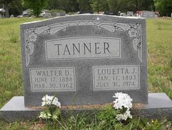
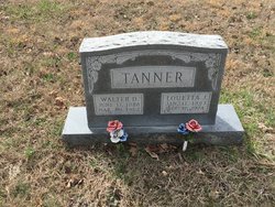
Walter David Tanner
| Birth | : | 17 Jun 1888 Saline County, Illinois, USA |
| Death | : | 30 Mar 1962 Doniphan, Ripley County, Missouri, USA |
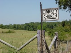
| Burial | : | Liberty Cemetery, Calm, Oregon County, USA |
| Coordinate | : | 36.5586500, -91.1549600 |
frequently asked questions (FAQ):
-
Where is Walter David Tanner's memorial?
Walter David Tanner's memorial is located at: Liberty Cemetery, Calm, Oregon County, USA.
-
When did Walter David Tanner death?
Walter David Tanner death on 30 Mar 1962 in Doniphan, Ripley County, Missouri, USA
-
Where are the coordinates of the Walter David Tanner's memorial?
Latitude: 36.5586500
Longitude: -91.1549600
Family Members:
Parent

Spouse
Siblings
Children
Flowers:


Nearby Cemetories:
1. Liberty Cemetery
Calm, Oregon County, USA
Coordinate: 36.5586500, -91.1549600
2. Pigman Mound Archeological Site
Calm, Oregon County, USA
Coordinate: 36.5717100, -91.1784800
3. Pleasant Hill Cemetery
Calm, Oregon County, USA
Coordinate: 36.5950012, -91.1425018
4. Spring Valley Cemetery
Billmore, Oregon County, USA
Coordinate: 36.5324670, -91.2003420
5. Mount Carmel Cemetery
Calm, Oregon County, USA
Coordinate: 36.5106010, -91.1643982
6. Old Elmore Thomas field
Billmore, Oregon County, USA
Coordinate: 36.5237770, -91.1980250
7. Gatewood Cemetery
Gatewood, Ripley County, USA
Coordinate: 36.5751600, -91.0900900
8. New Home Cemetery
Tucker (Gatewood), Ripley County, USA
Coordinate: 36.5112100, -91.1089800
9. Tucker Cemetery
Tucker (Gatewood), Ripley County, USA
Coordinate: 36.5426417, -91.0757139
10. O'Neal
Billmore, Oregon County, USA
Coordinate: 36.5712170, -91.2415410
11. Dobbs Lahue Cemetery
Riverton, Oregon County, USA
Coordinate: 36.6269300, -91.1823600
12. Dobbs-LaHue Cemetery
Riverton, Oregon County, USA
Coordinate: 36.6233978, -91.1966476
13. Walnut Grove Cemetery
Elm Store, Randolph County, USA
Coordinate: 36.4914017, -91.1967010
14. Old Jobe Cemetery
Jobe, Oregon County, USA
Coordinate: 36.5917015, -91.2517014
15. Roberts Family Farm Cemetery
Couch, Oregon County, USA
Coordinate: 36.6165300, -91.2401700
16. Cotton Creek Cemetery
Jobe, Oregon County, USA
Coordinate: 36.5844002, -91.2652969
17. Coe Cemetery
Warm Springs, Randolph County, USA
Coordinate: 36.4732400, -91.1102200
18. Riverton Cemetery
Riverton, Oregon County, USA
Coordinate: 36.6476100, -91.2076900
19. Stubblefield Cemetery
Dalton, Randolph County, USA
Coordinate: 36.4597015, -91.1718979
20. Church of God Cemetery
Oregon County, USA
Coordinate: 36.5023500, -91.2580200
21. Myrtle Cemetery
Myrtle, Oregon County, USA
Coordinate: 36.5133900, -91.2664300
22. Boze Mill Cemetery
Boze Mill, Oregon County, USA
Coordinate: 36.6631126, -91.1940231
23. Macedonia Cemetery
Warm Springs, Randolph County, USA
Coordinate: 36.4707985, -91.0742035
24. Reynolds Cemetery
Elm Store, Randolph County, USA
Coordinate: 36.4491997, -91.1860962