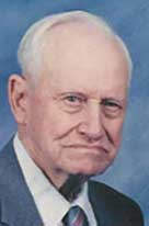
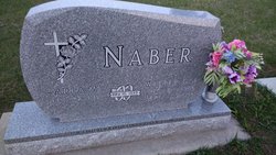
Walter Gehardt Fred Naber
| Birth | : | 20 Dec 1915 Cuming County, Nebraska, USA |
| Death | : | 7 Sep 2005 Albion, Boone County, Nebraska, USA |
| Burial | : | West Lawn Cemetery, Gering, Scotts Bluff County, USA |
| Coordinate | : | 41.8167000, -103.6849976 |
| Description | : | Walter Gehardt Fred Naber, the son of Fred and Johanna (Rastede) Naber was born on December 20, 1915 at his parents home in Cuming County. He attended school at Cuming County School District #46 and graduated from Uehling High School in 1934. On May 10, 1939 Walter was united in marriage to Arla Mae Witt at the United Lutheran Church in Scribner, NE. They lived on a farm in Cuming County until moving to a farm in Boone County in 1942. In 1991 the couple moved into Albion then retired in 1994. For the past 3 years they have... Read More |
frequently asked questions (FAQ):
-
Where is Walter Gehardt Fred Naber's memorial?
Walter Gehardt Fred Naber's memorial is located at: West Lawn Cemetery, Gering, Scotts Bluff County, USA.
-
When did Walter Gehardt Fred Naber death?
Walter Gehardt Fred Naber death on 7 Sep 2005 in Albion, Boone County, Nebraska, USA
-
Where are the coordinates of the Walter Gehardt Fred Naber's memorial?
Latitude: 41.8167000
Longitude: -103.6849976
Family Members:
Parent
Spouse
Siblings
Children
Flowers:
Nearby Cemetories:
1. West Lawn Cemetery
Gering, Scotts Bluff County, USA
Coordinate: 41.8167000, -103.6849976
2. Saint Francis Episcopal Church Columbarium
Scottsbluff, Scotts Bluff County, USA
Coordinate: 41.8665000, -103.6617500
3. Fairview Cemetery
Scottsbluff, Scotts Bluff County, USA
Coordinate: 41.8857994, -103.6536026
4. Pierre Didier Papin Gravesite
Gering, Scotts Bluff County, USA
Coordinate: 41.7353783, -103.6983490
5. Sunset Memorial Park
Scottsbluff, Scotts Bluff County, USA
Coordinate: 41.8997002, -103.7166977
6. Pioneer Graves
Scotts Bluff County, USA
Coordinate: 41.8057785, -103.8303909
7. Creighton Valley Cemetery
Melbeta, Scotts Bluff County, USA
Coordinate: 41.7482300, -103.5580400
8. Mitchell Valley Cemetery
Mitchell, Scotts Bluff County, USA
Coordinate: 41.8877983, -103.8311005
9. East Lawn Cemetery
Minatare, Scotts Bluff County, USA
Coordinate: 41.8591995, -103.5177994
10. Mitchell Cemetery
Mitchell, Scotts Bluff County, USA
Coordinate: 41.9585991, -103.8214035
11. Caldwell Pioneer Graves
Scotts Bluff County, USA
Coordinate: 41.8911812, -103.9287087
12. High Butte Cemetery
McGrew, Scotts Bluff County, USA
Coordinate: 41.7289009, -103.4353027
13. Caldwell Cemetery
Scotts Bluff County, USA
Coordinate: 41.8997002, -103.9768982
14. Pleasant Hill Cemetery
Harrisburg, Banner County, USA
Coordinate: 41.6699982, -103.9449997
15. Forest Lawn Cemetery
Morrill, Scotts Bluff County, USA
Coordinate: 41.9919014, -103.9128036
16. Jensen Cemetery
Banner County, USA
Coordinate: 41.5719550, -103.8112790
17. Bayard Cemetery
Bayard, Morrill County, USA
Coordinate: 41.7666910, -103.3236600
18. Harrisburg Cemetery
Banner County, USA
Coordinate: 41.5427010, -103.7158430
19. Chimney Rock Cemetery
Morrill County, USA
Coordinate: 41.6991997, -103.3399963
20. Gabe Rock Cemetery
Banner County, USA
Coordinate: 41.5668200, -103.8700200
21. Henry Crypt
Henry, Scotts Bluff County, USA
Coordinate: 42.0001000, -104.0454000
22. Morrill County Rural Burial Site
Bayard, Morrill County, USA
Coordinate: 41.7312100, -103.2353100
23. Kirk Cemetery
Harrisburg, Banner County, USA
Coordinate: 41.5103480, -103.4653220
24. Chaulk Creek Cemetery
Harrisburg, Banner County, USA
Coordinate: 41.5496560, -103.3781240


