

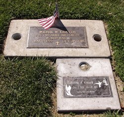

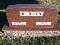
Wilbur W. “Will” Krauth
| Birth | : | 9 May 1922 Corning, Adams County, Iowa, USA |
| Death | : | 28 Oct 2014 Lompoc, Santa Barbara County, California, USA |
| Burial | : | Lompoc Evergreen Cemetery, Lompoc, Santa Barbara County, USA |
| Coordinate | : | 34.6296997, -120.4477997 |
| Plot | : | Grave 33, Tier 24, East Olive Lawn |
| Inscription | : | S Sgt US Army Air Forces World War ll |
| Description | : | Wilbur "Will" W. Krauth of Lompoc died Tuesday, October 28, 2014, at the age of 92. Will was born May 9, 1922 in Corning, Iowa to Ralph and Mabel Krauth. He was raised and educated in Corning before graduating from Iowa State Teachers College in Cedar Falls. He later earned a master's degree in education from the Iowa State University in Iowa City. Will was drafted into military service during World War II and served in the United States Air Force at McDill Air Force Base in Tampa, Florida. Formerly of Sioux City, Iowa will has been a resident of Lompoc since 1964.... Read More |
frequently asked questions (FAQ):
-
Where is Wilbur W. “Will” Krauth's memorial?
Wilbur W. “Will” Krauth's memorial is located at: Lompoc Evergreen Cemetery, Lompoc, Santa Barbara County, USA.
-
When did Wilbur W. “Will” Krauth death?
Wilbur W. “Will” Krauth death on 28 Oct 2014 in Lompoc, Santa Barbara County, California, USA
-
Where are the coordinates of the Wilbur W. “Will” Krauth's memorial?
Latitude: 34.6296997
Longitude: -120.4477997
Family Members:
Parent

Spouse
Siblings
Flowers:


Nearby Cemetories:
1. Lompoc Evergreen Cemetery
Lompoc, Santa Barbara County, USA
Coordinate: 34.6296997, -120.4477997
2. Mission La Purisima Concepcion Cemetery
Lompoc, Santa Barbara County, USA
Coordinate: 34.6716652, -120.4216690
3. Saint Mary's Episcopal Memory Garden
Lompoc, Santa Barbara County, USA
Coordinate: 34.6807100, -120.4533500
4. Guillermo Eduardo de la Guerra Burial Site
Los Alamos, Santa Barbara County, USA
Coordinate: 34.7500000, -120.3500000
5. Los Alamos Cemetery
Los Alamos, Santa Barbara County, USA
Coordinate: 34.7327995, -120.2807999
6. Pine Grove Cemetery
Santa Barbara County, USA
Coordinate: 34.8550430, -120.4185950
7. Solvang Cemetery
Solvang, Santa Barbara County, USA
Coordinate: 34.6017000, -120.1443920
8. Mission Santa Ines Cemetery
Solvang, Santa Barbara County, USA
Coordinate: 34.5943880, -120.1365550
9. Saint Mark's-in-the-Valley Church Mem. Garden
Los Olivos, Santa Barbara County, USA
Coordinate: 34.6662590, -120.1177210
10. San Ramon Chapel Cemetery
Santa Barbara County, USA
Coordinate: 34.8478012, -120.2394028
11. Oak Hill Cemetery
Ballard, Santa Barbara County, USA
Coordinate: 34.6324997, -120.1106033
12. Santa Maria Cemetery District
Santa Maria, Santa Barbara County, USA
Coordinate: 34.9369011, -120.4253006
13. Dudley-Hoffman Memory Gardens Columbarium
Santa Maria, Santa Barbara County, USA
Coordinate: 34.9388480, -120.4215260
14. Bethel Lutheran Church Resurrection Garden
Santa Maria, Santa Barbara County, USA
Coordinate: 34.9415700, -120.4279900
15. Ontiveros Cemetery
Los Alamos, Santa Barbara County, USA
Coordinate: 34.8897000, -120.2334900
16. Our Lady of Guadalupe Catholic Cemetery
Guadalupe, Santa Barbara County, USA
Coordinate: 34.9284800, -120.5911300
17. Rancho del Cielo Cemetery
Santa Barbara, Santa Barbara County, USA
Coordinate: 34.5304780, -120.0758920
18. Guadalupe Cemetery
Guadalupe, Santa Barbara County, USA
Coordinate: 34.9582863, -120.5741501
19. Capuchin Cemetery
Santa Ynez, Santa Barbara County, USA
Coordinate: 34.6442860, -120.0270440
20. Saint Joseph of Cupertino Province Cemetery
San Luis Obispo County, USA
Coordinate: 35.0718803, -120.5263519
21. Saint John's Lutheran Church Columbarium
Arroyo Grande, San Luis Obispo County, USA
Coordinate: 35.1032070, -120.5808630
22. Halcyon Cemetery
Halcyon, San Luis Obispo County, USA
Coordinate: 35.1062000, -120.5994990
23. Saint Barnabas Memorial Garden
Arroyo Grande, San Luis Obispo County, USA
Coordinate: 35.1179910, -120.5706380
24. Arroyo Grande Cemetery
Arroyo Grande, San Luis Obispo County, USA
Coordinate: 35.1230011, -120.5930634