
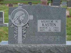
Wilhelm H Kasten
| Birth | : | 1 Mar 1901 Germany |
| Death | : | 18 Sep 1960 Pierce County, Nebraska, USA |
| Burial | : | Langold Cemetery, Worksop, Bassetlaw District, England |
| Coordinate | : | 53.3777600, -1.1170100 |
| Description | : | Parents: Hermann and Maria (Porath) Kasten |
frequently asked questions (FAQ):
-
Where is Wilhelm H Kasten's memorial?
Wilhelm H Kasten's memorial is located at: Langold Cemetery, Worksop, Bassetlaw District, England.
-
When did Wilhelm H Kasten death?
Wilhelm H Kasten death on 18 Sep 1960 in Pierce County, Nebraska, USA
-
Where are the coordinates of the Wilhelm H Kasten's memorial?
Latitude: 53.3777600
Longitude: -1.1170100
Family Members:
Spouse
Flowers:


Nearby Cemetories:
1. Langold Cemetery
Worksop, Bassetlaw District, England
Coordinate: 53.3777600, -1.1170100
2. St Helen's Roman Catholic Churchyard
Nottingham, Nottingham Unitary Authority, England
Coordinate: 53.3903220, -1.1131860
3. St. Peter's Churchyard
Letwell, Metropolitan Borough of Rotherham, England
Coordinate: 53.3773774, -1.1606489
4. St. Martin Churchyard
Firbeck, Metropolitan Borough of Rotherham, England
Coordinate: 53.3900080, -1.1561770
5. Saint John the Evangelist Churchyard
Carlton-in-Lindrick, Bassetlaw District, England
Coordinate: 53.3486389, -1.1180278
6. St. Mary & St. Martin Churchyard
Blyth, Bassetlaw District, England
Coordinate: 53.3785000, -1.0642000
7. Sandbeck Park
Maltby, Metropolitan Borough of Rotherham, England
Coordinate: 53.4061450, -1.1460050
8. Blyth City Cemetery
Blyth, Bassetlaw District, England
Coordinate: 53.3729000, -1.0592000
9. Styrrup Road Cemetery
Harworth, Bassetlaw District, England
Coordinate: 53.4160400, -1.0816770
10. St. George's Churchyard
Woodsetts, Metropolitan Borough of Rotherham, England
Coordinate: 53.3476000, -1.1729800
11. Roche Abbey
Maltby, Metropolitan Borough of Rotherham, England
Coordinate: 53.4025000, -1.1834000
12. All Saints Churchyard
Harworth, Bassetlaw District, England
Coordinate: 53.4187800, -1.0781900
13. Harworth Cemetery
Harworth, Bassetlaw District, England
Coordinate: 53.4185060, -1.0733460
14. Austin Friars Churchyard
Tickhill, Metropolitan Borough of Doncaster, England
Coordinate: 53.4283270, -1.1194740
15. Tickhill Friary
Tickhill, Metropolitan Borough of Doncaster, England
Coordinate: 53.4283330, -1.1195830
16. St. Mary's Churchyard
Tickhill, Metropolitan Borough of Doncaster, England
Coordinate: 53.4309200, -1.1112200
17. Saint Mary's Cemetery
Tickhill, Metropolitan Borough of Doncaster, England
Coordinate: 53.4315867, -1.1108661
18. Dinnington Church Cemetery
Dinnington St John's, Metropolitan Borough of Rotherham, England
Coordinate: 53.3699557, -1.2117994
19. Park Avenue Cemetery
Dinnington St John's, Metropolitan Borough of Rotherham, England
Coordinate: 53.3633710, -1.2100700
20. St John's Church Cemetery
Dinnington St John's, Metropolitan Borough of Rotherham, England
Coordinate: 53.3818248, -1.2135210
21. St John's Churchyard
Throapham, Metropolitan Borough of Rotherham, England
Coordinate: 53.3823850, -1.2147036
22. St. Barnabas Church Burial Ground
Ranskill, Bassetlaw District, England
Coordinate: 53.3786660, -1.0138210
23. All Saints Churchyard
Laughton-en-le-Morthen, Metropolitan Borough of Rotherham, England
Coordinate: 53.3882454, -1.2243221
24. St Winifred Churchyard
Stainton, Metropolitan Borough of Doncaster, England
Coordinate: 53.4367385, -1.1657988