
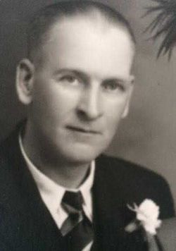
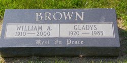
William Aitken “Bill” Brown
| Birth | : | 5 Aug 1910 |
| Death | : | 18 Oct 2000 Calgary, Calgary Census Division, Alberta, Canada |
| Burial | : | Vulcan Cemetery, Vulcan, Strathmore Census Division, Canada |
| Coordinate | : | 50.4032200, -113.2774100 |
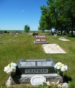
| Plot | : | Block 8 Lot 3 Grave 34 |
| Description | : | VULCAN FUNERAL HOME - OBIT EXCERPTS WILLIAM AITKEN “BILL” BROWN, FORMERLY OF LOMOND PASSED AWAY PEACEFULLY OCTOBER 18, 2000 AT THE FOOTHILLS HOSPITAL CALGARY AT THE AGE OF 90 YEARS. BILL WAS BORN ON THE BROWN HOMESTEAD AT WHEAT CENTRE ON AUGUST 5, 1910. AS A YOUNG MAN HE DELIVERED MAIL TO BOW CITY, BADGER LAKE, AND WHEAT CENTRE. IN 1928 HE TOOK OUT HIS OWN HOMESTEAD AND STARTED FARMING. HE MARRIED GLADYS CHAPMAN OF LOMOND IN 1949. THEY RAISED THEIR TWO SONS, BILLY AND ROBERT ON THE FARM AND RETIRED TO LOMOND IN 1978. GLADYS PASSED AWAY IN... Read More |
frequently asked questions (FAQ):
-
Where is William Aitken “Bill” Brown's memorial?
William Aitken “Bill” Brown's memorial is located at: Vulcan Cemetery, Vulcan, Strathmore Census Division, Canada.
-
When did William Aitken “Bill” Brown death?
William Aitken “Bill” Brown death on 18 Oct 2000 in Calgary, Calgary Census Division, Alberta, Canada
-
Where are the coordinates of the William Aitken “Bill” Brown's memorial?
Latitude: 50.4032200
Longitude: -113.2774100
Family Members:
Parent
Spouse
Siblings
Flowers:


Nearby Cemetories:
1. Vulcan Cemetery
Vulcan, Strathmore Census Division, Canada
Coordinate: 50.4032200, -113.2774100
2. Highland Cemetery
Vulcan, Strathmore Census Division, Canada
Coordinate: 50.4845700, -113.2659100
3. Cleverville Cemetery
Champion, Strathmore Census Division, Canada
Coordinate: 50.2736100, -113.1661700
4. Reid Hill Cemetery
Vulcan, Strathmore Census Division, Canada
Coordinate: 50.3974000, -113.0295500
5. Brant Cemetery
Brant, Strathmore Census Division, Canada
Coordinate: 50.5067400, -113.5068000
6. Fath Hill Catholic Cemetery
Champion, Strathmore Census Division, Canada
Coordinate: 50.2153400, -113.2544200
7. Champion Cemetery
Champion, Strathmore Census Division, Canada
Coordinate: 50.2329200, -113.1441800
8. Sharon Cemetery
Brant, Strathmore Census Division, Canada
Coordinate: 50.4555300, -113.5740800
9. Little Bow Hutterite Cemetery
Stavely, Claresholm Census Division, Canada
Coordinate: 50.2142141, -113.3694417
10. Isol Russell Grave
Champion, Strathmore Census Division, Canada
Coordinate: 50.1792300, -113.2102100
11. Alston Cemetery
Vulcan, Strathmore Census Division, Canada
Coordinate: 50.1652820, -113.2450470
12. Arrowwood Hutterite Cemetery
Herronton, Strathmore Census Division, Canada
Coordinate: 50.6368299, -113.4157544
13. High River Hutterite Cemetery
High River, Calgary Census Division, Canada
Coordinate: 50.4816260, -113.6618863
14. Frankburg Cemetery
High River, Calgary Census Division, Canada
Coordinate: 50.5287300, -113.6445850
15. Krasivaya Dolina Cemetery
Queenstown, Strathmore Census Division, Canada
Coordinate: 50.5908100, -112.9593600
16. Carmangay Cemetery
Carmangay, Strathmore Census Division, Canada
Coordinate: 50.1214300, -113.1434300
17. Hope Lutheran Cemetery
Milo, Strathmore Census Division, Canada
Coordinate: 50.6013300, -112.9238900
18. Blackie Cemetery
Blackie, Calgary Census Division, Canada
Coordinate: 50.6084400, -113.6290500
19. St. Cecilia's Roman Catholic Cemetery
Nanton, Claresholm Census Division, Canada
Coordinate: 50.3588000, -113.7591600
20. Nanton Town Cemetery
Nanton, Claresholm Census Division, Canada
Coordinate: 50.3333800, -113.7586100
21. Saint Vincent Roman Catholic Cemetery
Stavely, Claresholm Census Division, Canada
Coordinate: 50.1717670, -113.6409830
22. Shadow Ranch Hutterite Cemetery
Champion, Strathmore Census Division, Canada
Coordinate: 50.1820466, -112.8929664
23. Arrowwood Cemetery
Arrowwood, Strathmore Census Division, Canada
Coordinate: 50.7211418, -113.1209030
24. Stavely Cemetery
Stavely, Claresholm Census Division, Canada
Coordinate: 50.1646700, -113.6625600