
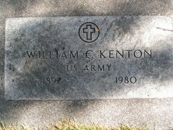
William Clifford “Bill” Kenton
| Birth | : | 7 Mar 1897 San Francisco, San Francisco County, California, USA |
| Death | : | 1 Feb 1980 Wenatchee, Chelan County, Washington, USA |
| Burial | : | St. Andrew Churchyard, Cavenham, Forest Heath District, England |
| Coordinate | : | 52.2969400, 0.5849100 |
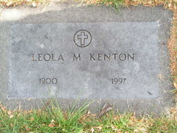
| Description | : | m: Leola Heilman 15 Mar 1943 in Chelan Co, WA |
frequently asked questions (FAQ):
-
Where is William Clifford “Bill” Kenton's memorial?
William Clifford “Bill” Kenton's memorial is located at: St. Andrew Churchyard, Cavenham, Forest Heath District, England.
-
When did William Clifford “Bill” Kenton death?
William Clifford “Bill” Kenton death on 1 Feb 1980 in Wenatchee, Chelan County, Washington, USA
-
Where are the coordinates of the William Clifford “Bill” Kenton's memorial?
Latitude: 52.2969400
Longitude: 0.5849100
Family Members:
Spouse
Flowers:


Nearby Cemetories:
1. St. Andrew Churchyard
Cavenham, Forest Heath District, England
Coordinate: 52.2969400, 0.5849100
2. St. Mary's Churchyard
Tuddenham, Forest Heath District, England
Coordinate: 52.3126400, 0.5481500
3. All Saints Churchyard
Icklingham, Forest Heath District, England
Coordinate: 52.3227766, 0.6041408
4. St James Churchyard
Icklingham, Forest Heath District, England
Coordinate: 52.3269540, 0.5966680
5. St Lawrence's Churchyard
Lackford, St Edmundsbury Borough, England
Coordinate: 52.3011950, 0.6349270
6. St. Stephen Churchyard
Higham, Forest Heath District, England
Coordinate: 52.2606300, 0.5575500
7. St Ethelbert's Church
Herringswell, Forest Heath District, England
Coordinate: 52.3008595, 0.5182833
8. St Catherine Churchyard
Flempton, St Edmundsbury Borough, England
Coordinate: 52.2975220, 0.6575680
9. All Saints Churchyard
Barrow, St Edmundsbury Borough, England
Coordinate: 52.2515891, 0.5786771
10. St Giles Churchyard
Risby, St Edmundsbury Borough, England
Coordinate: 52.2661320, 0.6397400
11. Barrow Cemetery
Barrow, St Edmundsbury Borough, England
Coordinate: 52.2514210, 0.5813940
12. St Giles War Memorial - Risby
Risby, St Edmundsbury Borough, England
Coordinate: 52.2660130, 0.6396260
13. St Mary's Churchyard
West Stow, St Edmundsbury Borough, England
Coordinate: 52.3028860, 0.6669420
14. Raunds Wesleyan Methodist Chapel Yard
Raunds, East Northamptonshire Borough, England
Coordinate: 52.3432300, 0.5371100
15. Church of the Reconciliation
Hengrave, St Edmundsbury Borough, England
Coordinate: 52.2850270, 0.6733120
16. St Mary the Virgin Churchyard
Barton Mills, Forest Heath District, England
Coordinate: 52.3353300, 0.5188900
17. St. Mary Churchyard
Kentford, Forest Heath District, England
Coordinate: 52.2726600, 0.4997800
18. St. Nicholas Churchyard
Kennett, East Cambridgeshire District, England
Coordinate: 52.2870190, 0.4904830
19. Mildenhall cemetery
Mildenhall, Forest Heath District, England
Coordinate: 52.3450530, 0.5276780
20. West Suffolk Crematorium
Risby, St Edmundsbury Borough, England
Coordinate: 52.2600280, 0.6648640
21. All Saints Churchyard
Wordwell, St Edmundsbury Borough, England
Coordinate: 52.3159590, 0.6806370
22. St Nicholas Churchyard
Little Saxham, St Edmundsbury Borough, England
Coordinate: 52.2421640, 0.6338780
23. St Mary's Churchyard
Culford, St Edmundsbury Borough, England
Coordinate: 52.3002000, 0.6874000
24. Kingsway Old Cemetery
Mildenhall, Forest Heath District, England
Coordinate: 52.3441770, 0.5148110