
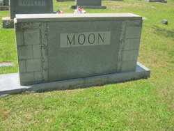
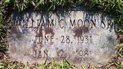
William Clyde “Bill” Moon Sr.
| Birth | : | 28 Jun 1931 Randolph County, North Carolina, USA |
| Death | : | 2 Jan 1981 Chapel Hill, Orange County, North Carolina, USA |
| Burial | : | West Resthaven Park Cemetery, Glendale, Maricopa County, USA |
| Coordinate | : | 33.5522003, -112.1931000 |
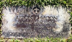
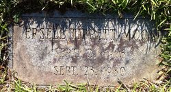
| Description | : | William was the only child of Alton Clyde and Ersell Rochelle (Tippett) Moon. He married Frances Sams and they were the parents of two children: William Clyde Jr. and Gina Rochelle. Greensboro Daily News, NC January 3, 1981 WILLIAM MOON RAMSEUR - William "Bill" Moon, 49, of 218 S. Church St. Asheboro, died Friday at N. C. Memorial Hospital in Chapel Hill. Funeral will be 3 p.m. Sunday at Franklinville United Methodist Church with the Rev. D. B. Martin officiating. Burial will be at the church. He was a Randolph County native. Surviving are son, William C. Moon Jr. of the home; daughter, Miss Gina Moon of... Read More |
frequently asked questions (FAQ):
-
Where is William Clyde “Bill” Moon Sr.'s memorial?
William Clyde “Bill” Moon Sr.'s memorial is located at: West Resthaven Park Cemetery, Glendale, Maricopa County, USA.
-
When did William Clyde “Bill” Moon Sr. death?
William Clyde “Bill” Moon Sr. death on 2 Jan 1981 in Chapel Hill, Orange County, North Carolina, USA
-
Where are the coordinates of the William Clyde “Bill” Moon Sr.'s memorial?
Latitude: 33.5522003
Longitude: -112.1931000
Family Members:
Parent
Children
Flowers:


Nearby Cemetories:
1. Glendale Memorial Park
Glendale, Maricopa County, USA
Coordinate: 33.5518990, -112.1908035
2. Rest haven Memorial Park
Glendale, Maricopa County, USA
Coordinate: 33.5541251, -112.1840380
3. Russian Molokan Cemetery
Maricopa County, USA
Coordinate: 33.5307999, -112.2189026
4. Trinity Mennonite Church Columbarium
Glendale, Maricopa County, USA
Coordinate: 33.5468000, -112.1529000
5. Saint Marys Episcopal Church Cemetery
Phoenix, Maricopa County, USA
Coordinate: 33.5321080, -112.1431430
6. Trinity United Methodist Church Memorial Garden
Phoenix, Maricopa County, USA
Coordinate: 33.5387480, -112.1261220
7. Old Paths Cemetery
Peoria, Maricopa County, USA
Coordinate: 33.6124000, -112.2137000
8. Garden of Memories Columbarium and Garden
Peoria, Maricopa County, USA
Coordinate: 33.5814000, -112.2623000
9. Shepherd of the Valley United Methodist Church
Phoenix, Maricopa County, USA
Coordinate: 33.5959600, -112.1250450
10. Our Savior Lutheran Church Columbarium
Sun City, Maricopa County, USA
Coordinate: 33.5734230, -112.2804520
11. Saint Christopher Episcopal Church Memorial Garden
Sun City, Maricopa County, USA
Coordinate: 33.5796000, -112.2809000
12. Church of the Palms UCC Memorial Garden
Sun City, Maricopa County, USA
Coordinate: 33.5974998, -112.2711105
13. First United Methodist Church Columbarium
Sun City, Maricopa County, USA
Coordinate: 33.5740210, -112.2861820
14. Shepherd of the Valley Lutheran Church
Phoenix, Maricopa County, USA
Coordinate: 33.5315580, -112.0914890
15. Lakeview United Methodist Church Columbarium
Sun City, Maricopa County, USA
Coordinate: 33.6057549, -112.2797546
16. Shepherd of the Desert Lutheran Church Columbarium
Sun City, Maricopa County, USA
Coordinate: 33.5842890, -112.2981500
17. Trinity Lutheran Church Columbarium
Phoenix, Maricopa County, USA
Coordinate: 33.5723530, -112.0829490
18. Church of the Beatitudes Columbarium
Phoenix, Maricopa County, USA
Coordinate: 33.5380000, -112.0815000
19. Bellevue Heights Church Columbarium
Sun City, Maricopa County, USA
Coordinate: 33.6336360, -112.2628940
20. All Saints of the Desert Episcopal Church Cemetery
Sun City, Maricopa County, USA
Coordinate: 33.6340000, -112.2643000
21. All Saints Episcopal Church Cemetery
Phoenix, Maricopa County, USA
Coordinate: 33.5297000, -112.0746000
22. Holy Cross Cemetery
Avondale, Maricopa County, USA
Coordinate: 33.4767890, -112.2775830
23. Shadow Rock Congregational Church Cemetery
Phoenix, Maricopa County, USA
Coordinate: 33.6025000, -112.0832000
24. First United Methodist Church Columbarium
Phoenix, Maricopa County, USA
Coordinate: 33.5167465, -112.0740433