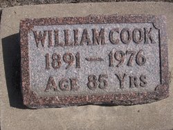
William Cook
| Birth | : | 28 May 1891 Saint Francis, Cheyenne County, Kansas, USA |
| Death | : | 11 Jul 1976 Saint Francis, Cheyenne County, Kansas, USA |
| Burial | : | Charlton Park Cemetery, Gore, Gore District, New Zealand |
| Coordinate | : | -46.1265490, 168.8992730 |
| Description | : | William Cook, son of John and Theresia Cook, was born in Cheyenne County, Kansas, June 18, 1891. He passed away July 11, 1976, at the age of 85 at the Miller Rest Home in St. Francis. He was born in a sod house, attended a country school, took a short course in agriculture at Manhattan. He was very interested in baseball as he served as manager and catcher for the Cook Brothers Ball Team and Plum Creek Ball Team. He organized the Farmers Institute and served on the St. Francis Equity Board for several years. He accepted... Read More |
frequently asked questions (FAQ):
-
Where is William Cook's memorial?
William Cook's memorial is located at: Charlton Park Cemetery, Gore, Gore District, New Zealand.
-
When did William Cook death?
William Cook death on 11 Jul 1976 in Saint Francis, Cheyenne County, Kansas, USA
-
Where are the coordinates of the William Cook's memorial?
Latitude: -46.1265490
Longitude: 168.8992730
Family Members:
Parent
Siblings
Flowers:
Nearby Cemetories:
1. Charlton Park Cemetery
Gore, Gore District, New Zealand
Coordinate: -46.1265490, 168.8992730
2. Gore Cemetery
Gore, Gore District, New Zealand
Coordinate: -46.0900000, 168.9360000
3. Mataura Cemetery
Mataura, Gore District, New Zealand
Coordinate: -46.2016960, 168.8808060
4. Otaraia Cemetery
Gore District, New Zealand
Coordinate: -46.1978780, 169.0815990
5. Pukerau Cemetery
Pukerau, Gore District, New Zealand
Coordinate: -46.0989170, 169.1057690
6. Wyndham Cemetery
Wyndham, Southland District, New Zealand
Coordinate: -46.3147020, 168.8823690
7. Waikoikoi Cemetery
Waikoikoi, Clutha District, New Zealand
Coordinate: -46.0257040, 169.1568238
8. Waikaka Cemetery
Waikaka, Gore District, New Zealand
Coordinate: -45.9312400, 169.0188900
9. Edendale Cemetery
Edendale, Southland District, New Zealand
Coordinate: -46.3080400, 168.7327360
10. Waipahi Cemetery
Waipahi, Clutha District, New Zealand
Coordinate: -46.1019420, 169.2380910
11. Riversdale Cemetery
Riversdale, Southland District, New Zealand
Coordinate: -45.9180100, 168.7263600
12. Tapanui Cemetery
Tapanui, Clutha District, New Zealand
Coordinate: -45.9425830, 169.2832320
13. Mokoreta Cemetery
Southland District, New Zealand
Coordinate: -46.4332000, 169.0649650
14. Clinton Cemetery
Clinton, Clutha District, New Zealand
Coordinate: -46.1971400, 169.3638100
15. Woodlands Cemetery
Woodlands, Southland District, New Zealand
Coordinate: -46.3568800, 168.5463770
16. Balfour Cemetery
Balfour, Southland District, New Zealand
Coordinate: -45.8391000, 168.5986640
17. Forest Hill Cemetery
Southland District, New Zealand
Coordinate: -46.2049720, 168.3969970
18. East Winton Cemetery
Winton, Southland District, New Zealand
Coordinate: -46.1374640, 168.3557030
19. Winton Cemetery
Winton, Southland District, New Zealand
Coordinate: -46.1289300, 168.3250400
20. Waikaia Cemetery
Waikaia, Southland District, New Zealand
Coordinate: -45.7169300, 168.8490600
21. Crookston Cemetery
Heriot, Clutha District, New Zealand
Coordinate: -45.8375170, 169.3251600
22. Ryal Bush
Ryal Bush, Southland District, New Zealand
Coordinate: -46.2836700, 168.3256000
23. Quarry Hills Cemetery
Quarry Hills, Southland District, New Zealand
Coordinate: -46.5433100, 169.0398300
24. Dipton Cemetery
Dipton, Southland District, New Zealand
Coordinate: -45.8957730, 168.3508000

