

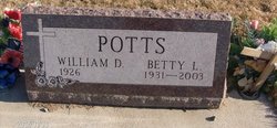
William D “Bill” Potts
| Birth | : | 19 Aug 1926 Sumatra, Rosebud County, Montana, USA |
| Death | : | 12 Sep 2015 Forsyth, Rosebud County, Montana, USA |
| Burial | : | Forsyth Cemetery, Forsyth, Rosebud County, USA |
| Coordinate | : | 46.2689018, -106.6528015 |
| Description | : | William D. Potts (AKA: Grampa, Grampa Bill, Grampa Pete and Big PaPa, Pop), age 89, of Rosebud passed away on Saturday, September 12, 2015 at the Rosebud HealthCare Center in Forsyth. Dad was born August 19, 1926 at Sumatra, Montana. He was born the youngest son of a family of seven to Adella and James Potts. Bill was raised in the Sumatra area and attended school at the Hibber Creek School until his family moved to the Custer area, where he went to school through the 6th grade. He quit school to help his parents and to work for farmers... Read More |
frequently asked questions (FAQ):
-
Where is William D “Bill” Potts's memorial?
William D “Bill” Potts's memorial is located at: Forsyth Cemetery, Forsyth, Rosebud County, USA.
-
When did William D “Bill” Potts death?
William D “Bill” Potts death on 12 Sep 2015 in Forsyth, Rosebud County, Montana, USA
-
Where are the coordinates of the William D “Bill” Potts's memorial?
Latitude: 46.2689018
Longitude: -106.6528015
Family Members:
Parent

Spouse
Siblings

Children
Flowers:


Nearby Cemetories:
1. Forsyth Cemetery
Forsyth, Rosebud County, USA
Coordinate: 46.2689018, -106.6528015
2. Rosebud Cemetery
Rosebud, Rosebud County, USA
Coordinate: 46.2689018, -106.4381027
3. Howard Cemetery
Rosebud County, USA
Coordinate: 46.2621994, -106.9222031
4. Hathaway Cemetery
Rosebud County, USA
Coordinate: 46.2616997, -106.2185974
5. Colstrip Cemetery
Colstrip, Rosebud County, USA
Coordinate: 45.9096985, -106.6194000
6. Memorial Vale Cemetery
Hysham, Treasure County, USA
Coordinate: 46.2552986, -107.2307968
7. Bean Cemetery
Rosebud County, USA
Coordinate: 45.8535995, -106.4011002
8. Brown Cemetery
Colstrip, Rosebud County, USA
Coordinate: 45.8321991, -106.4180984
9. Lee Cemetery
Rosebud County, USA
Coordinate: 45.7792015, -106.5413971
10. Rancher Cemetery
Myers, Treasure County, USA
Coordinate: 46.2580986, -107.4197006
11. Fort Keogh Cemetery
Custer County, USA
Coordinate: 46.3800011, -105.8874969
12. Vanstel Cemetery
Rosebud County, USA
Coordinate: 46.7872009, -106.8942032
13. Calvary Cemetery
Miles City, Custer County, USA
Coordinate: 46.3816986, -105.8249969
14. Eastern Montana State Veterans Cemetery
Miles City, Custer County, USA
Coordinate: 46.3807564, -105.8246536
15. Old Calvary Cemetery
Miles City, Custer County, USA
Coordinate: 46.3807600, -105.8246500
16. Custer County Cemetery
Miles City, Custer County, USA
Coordinate: 46.3891983, -105.8264008
17. Pine Hills School Cemetery
Miles City, Custer County, USA
Coordinate: 46.4077988, -105.8167038
18. Rock Springs Cemetery
Rock Springs, Rosebud County, USA
Coordinate: 46.7847800, -106.1411500
19. Pine Crest Cemetery
Custer County, USA
Coordinate: 46.4564018, -105.7789001
20. Junction City Cemetery
Yellowstone County, USA
Coordinate: 46.1437320, -107.5493300
21. Lame Deer Cemetery
Lame Deer, Rosebud County, USA
Coordinate: 45.6264000, -106.6619034
22. Custer Cemetery
Custer, Yellowstone County, USA
Coordinate: 46.1270690, -107.5700030
23. Muddy Creek Cemetery
Muddy, Big Horn County, USA
Coordinate: 45.5741997, -106.7406006
24. Saint Labre Cemetery
Ashland, Rosebud County, USA
Coordinate: 45.6070930, -106.2836910