
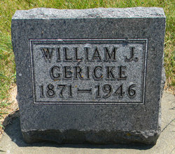
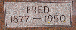
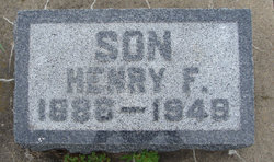
William J Gericke
| Birth | : | 29 Sep 1871 |
| Death | : | 19 Jan 1946 |
| Burial | : | Tracy Public Cemetery, Tracy, San Joaquin County, USA |
| Coordinate | : | 37.7251358, -121.4189453 |
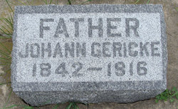
| Description | : | Private funeral services were held Tuesday afternoon at the Schutte Funeral Home in this city for William Gericke and burial was in Postville cemetery. The Rev. Frederick R. Ludwig officiated. Mr. Gericke was born at Clayton Center September 29, 1871, as the son of Mr. and Mrs. John Gericke. He came to this community when a young man of 18 or 19 years and followied farming in Post township until about 13 years ago, when he came to Postvile to make his home. For about 50 years he was a thresherman, operating his machine on many farms here. About 35... Read More |
frequently asked questions (FAQ):
-
Where is William J Gericke's memorial?
William J Gericke's memorial is located at: Tracy Public Cemetery, Tracy, San Joaquin County, USA.
-
When did William J Gericke death?
William J Gericke death on 19 Jan 1946 in
-
Where are the coordinates of the William J Gericke's memorial?
Latitude: 37.7251358
Longitude: -121.4189453
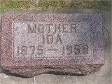
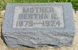
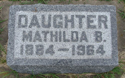
Family Members:
Parent
Siblings
Flowers:


Nearby Cemetories:
1. Tracy Public Cemetery
Tracy, San Joaquin County, USA
Coordinate: 37.7251358, -121.4189453
2. Tracy Mausoleum
Tracy, San Joaquin County, USA
Coordinate: 37.7250214, -121.4150696
3. Valpico Memorial Park
Tracy, San Joaquin County, USA
Coordinate: 37.7113260, -121.4656510
4. Brichetto Tomb
San Joaquin County, USA
Coordinate: 37.6272011, -121.3871994
5. East Union Cemetery
Manteca, San Joaquin County, USA
Coordinate: 37.8114014, -121.2350006
6. Congregation of Ahavas Achim Cemetery
French Camp, San Joaquin County, USA
Coordinate: 37.8778419, -121.2753067
7. Chinese Cemetery
French Camp, San Joaquin County, USA
Coordinate: 37.8819962, -121.2805862
8. Congregation Adas Yeshuran of Stockton Cemetery
French Camp, San Joaquin County, USA
Coordinate: 37.8784065, -121.2740784
9. Park View Cemetery
Manteca, San Joaquin County, USA
Coordinate: 37.8617249, -121.2238312
10. Five Pillars Farm Cemetery
Livermore, Alameda County, USA
Coordinate: 37.7262764, -121.7105789
11. Ripon Cemetery
Ripon, San Joaquin County, USA
Coordinate: 37.7420311, -121.1238708
12. Atlanta Cemetery
Five Corners, San Joaquin County, USA
Coordinate: 37.8270035, -121.1420135
13. Grayson Cemetery
Grayson, Stanislaus County, USA
Coordinate: 37.5594559, -121.1802826
14. Thomas Lindsay Gravesite
San Joaquin County, USA
Coordinate: 37.9573110, -121.2918430
15. David Kelsey Gravesite
Stockton, San Joaquin County, USA
Coordinate: 37.9573110, -121.2918430
16. Citizens Cemetery
Stockton, San Joaquin County, USA
Coordinate: 37.9559410, -121.2769120
17. Union Cemetery
Brentwood, Contra Costa County, USA
Coordinate: 37.9103012, -121.6477966
18. Temple Israel Cemetery
Stockton, San Joaquin County, USA
Coordinate: 37.9640541, -121.2784348
19. Stockton State Hospital Cemetery
Stockton, San Joaquin County, USA
Coordinate: 37.9663110, -121.2846850
20. Saint Michaels Cemetery
Livermore, Alameda County, USA
Coordinate: 37.6797790, -121.7519150
21. San Joaquin Catholic Cemetery
Stockton, San Joaquin County, USA
Coordinate: 37.9707830, -121.2850190
22. IOOF Memory Gardens Cemetery
Livermore, Alameda County, USA
Coordinate: 37.6797850, -121.7526100
23. Casa Bonita Mausoleum
Stockton, San Joaquin County, USA
Coordinate: 37.9752340, -121.2877800
24. Stockton Woodland Mausoleum
Stockton, San Joaquin County, USA
Coordinate: 37.9762400, -121.2878000