
| Birth | : | 1 May 1891 Surry County, North Carolina, USA |
| Death | : | 19 Aug 1986 Surry County, North Carolina, USA |
| Burial | : | Clinton Public Cemetery, Clinton, Huron County, Canada |
| Coordinate | : | 43.6351790, -81.5293200 |
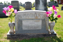
| Description | : | He married his half 3rd cousin. Twin to Milard Brastus Stanley. On 4 November 1906 when William Rastus "Rat" was 16, he married Lula JENKINS, daughter of William Hiram "Bill" JENKINS (1 July 1857 - 3 January 1940) & Mary Elizabeth "Betty" BLEDSOE (5 October 1867 - 23 May 1945), in Surry County, North Carolina. Born in 1888 in Surry County, North Carolina. Lula died in Surry County, North Carolina on 30 November 1935, she was 47. Buried on 1 December 1935 in Mount Pleasant Baptist Church Cemetery. S/O James Matthew and Carrie Mae Payne Key Stanley. Paternal grandparents were John Edmond and... Read More |
frequently asked questions (FAQ):
-
Where is William Rastus “Rat” Stanley's memorial?
William Rastus “Rat” Stanley's memorial is located at: Clinton Public Cemetery, Clinton, Huron County, Canada.
-
When did William Rastus “Rat” Stanley death?
William Rastus “Rat” Stanley death on 19 Aug 1986 in Surry County, North Carolina, USA
-
Where are the coordinates of the William Rastus “Rat” Stanley's memorial?
Latitude: 43.6351790
Longitude: -81.5293200
Family Members:
Parent

Spouse
Siblings
Flowers:


Nearby Cemetories:
1. Clinton Public Cemetery
Clinton, Huron County, Canada
Coordinate: 43.6351790, -81.5293200
2. Saint Joseph's Roman Catholic Cemetery
Hullett Township, Huron County, Canada
Coordinate: 43.6421190, -81.4980580
3. Holmesville Memorial Cemetery
Holmesville, Huron County, Canada
Coordinate: 43.6493090, -81.6074690
4. Turners Cemetery
Tuckersmith Township, Huron County, Canada
Coordinate: 43.5734540, -81.4893110
5. Londesborough Cemetery
Londesborough, Huron County, Canada
Coordinate: 43.6977800, -81.4812200
6. Kinburn United Cemetery
Kinburn, Huron County, Canada
Coordinate: 43.6307870, -81.4226600
7. Burns United Church Cemetery
Hullett Township, Huron County, Canada
Coordinate: 43.6720600, -81.4192660
8. Colborne Evangelical Cemetery
Colborne Township, Huron County, Canada
Coordinate: 43.7213800, -81.5891380
9. Hope Chapel Cemetery
Central Huron Township, Huron County, Canada
Coordinate: 43.7297610, -81.5031730
10. Ball's Cemetery
Hullett Township, Huron County, Canada
Coordinate: 43.7344320, -81.5418630
11. Baird's Cemetery
Brucefield, Huron County, Canada
Coordinate: 43.5387800, -81.5678100
12. Blyth Union Cemetery
Blyth, Huron County, Canada
Coordinate: 43.7300034, -81.4564743
13. Varna United-Memorial Cemetery
Stanley Township, Huron County, Canada
Coordinate: 43.5347640, -81.5950790
14. Harpurhey Presbyterian Cemetery
Harpurhey, Huron County, Canada
Coordinate: 43.5601460, -81.4149820
15. Ross United Presbyterian Cemetery
Brucefield, Huron County, Canada
Coordinate: 43.5216200, -81.5169800
16. Maitlandbank Cemetery
Seaforth, Huron County, Canada
Coordinate: 43.5740600, -81.3906500
17. German Evangelical Lutheran Cemetery
Hullett Township, Huron County, Canada
Coordinate: 43.7520530, -81.4856970
18. Bayfield Memorial Cemetery
Stanley Township, Huron County, Canada
Coordinate: 43.5453380, -81.6418570
19. Ross Free Presbyterian Cemetery
Brucefield, Huron County, Canada
Coordinate: 43.5118590, -81.5139350
20. Blyth Memorial Cairn
Blyth, Huron County, Canada
Coordinate: 43.7341580, -81.4242160
21. Blyth Anglican Potter's Historic Cemetery
Blyth, Huron County, Canada
Coordinate: 43.7441000, -81.4327200
22. Egmondville Cemetery
Egmondville, Huron County, Canada
Coordinate: 43.5398400, -81.4074380
23. Bayfield Cemetery
Bayfield, Huron County, Canada
Coordinate: 43.5584200, -81.6830700
24. Saint James Cemetery
Seaforth, Huron County, Canada
Coordinate: 43.5479180, -81.3798530