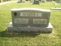
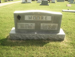
William Roy Moore
| Birth | : | 16 Sep 1909 Senath, Dunklin County, Missouri, USA |
| Death | : | 9 Apr 1979 Portageville, New Madrid County, Missouri, USA |
| Burial | : | Woodland Heights Cemetery, Rector, Clay County, USA |
| Coordinate | : | 36.2724991, -90.3039017 |
| Description | : | Services for Roy Moore, 69, retired merchant in Portageville, who died April 9th at his home, were held at 2 p.m. April 11th at DeLisle Funeral Home Chapel in Portageville with Ralph Steury and David Vaughn officiating. Burial was in Woodland Heights Cemetery, Rector, Ark. He was born Sept. 16, 1909 in Senath, son of the late Thomas J. and Elizabeth Norman Moore. On March 15th, 1930 he married Earlene Whitaker. Survivors include his wife, of the home; one son, Bill Moore of Caruthersville; two brothers, Herbert Moore of Sikeston and Norman W. Moore of Collingsville, Ill.; one sister, Mrs.... Read More |
frequently asked questions (FAQ):
-
Where is William Roy Moore's memorial?
William Roy Moore's memorial is located at: Woodland Heights Cemetery, Rector, Clay County, USA.
-
When did William Roy Moore death?
William Roy Moore death on 9 Apr 1979 in Portageville, New Madrid County, Missouri, USA
-
Where are the coordinates of the William Roy Moore's memorial?
Latitude: 36.2724991
Longitude: -90.3039017
Family Members:
Parent
Spouse
Siblings
Flowers:
Nearby Cemetories:
1. Woodland Heights Cemetery
Rector, Clay County, USA
Coordinate: 36.2724991, -90.3039017
2. Scatterville Cemetery
Rector, Clay County, USA
Coordinate: 36.2813683, -90.3131104
3. Parks Cemetery
Rector, Clay County, USA
Coordinate: 36.2619934, -90.3266754
4. Marys Chapel Cemetery
Rector, Clay County, USA
Coordinate: 36.2921982, -90.2830963
5. Mound Cemetery
Clay County, USA
Coordinate: 36.2737312, -90.3426285
6. Hillsboro Cemetery
Rector, Clay County, USA
Coordinate: 36.2975883, -90.2605820
7. Blooming Grove Cemetery
Clay County, USA
Coordinate: 36.3147011, -90.2913971
8. Pleasant Grove Cemetery
Hopewell, Greene County, USA
Coordinate: 36.2543983, -90.3630981
9. Ebenezer Cemetery
Clay County, USA
Coordinate: 36.2887383, -90.3643570
10. Shannon Cemetery
Clay County, USA
Coordinate: 36.2982483, -90.3639374
11. Liberty Hill Cemetery
Boydsville, Clay County, USA
Coordinate: 36.3280983, -90.3182983
12. Hargrave Parish Church
Hargrave Corner, Clay County, USA
Coordinate: 36.2590598, -90.2290688
13. Lone Grave
Clay County, USA
Coordinate: 36.3358002, -90.3331070
14. Travillian Cemetery
Clay County, USA
Coordinate: 36.3382988, -90.2842026
15. Purcell Cemetery
Rector, Clay County, USA
Coordinate: 36.2602997, -90.3910980
16. Leonard Cemetery
Leonard, Clay County, USA
Coordinate: 36.2164001, -90.2481003
17. Johnson Chapel Cemetery
Clay County, USA
Coordinate: 36.3383900, -90.3572400
18. Salem Cemetery
Rector, Clay County, USA
Coordinate: 36.3208008, -90.3818970
19. Mitchell Cemetery
Greenway, Clay County, USA
Coordinate: 36.3352013, -90.2378464
20. Cudd Cemetery
Marmaduke, Greene County, USA
Coordinate: 36.2202988, -90.3955994
21. Winston Cemetery
Clay County, USA
Coordinate: 36.3464012, -90.2382965
22. Harveys Chapel Cemetery
Marmaduke, Greene County, USA
Coordinate: 36.2131004, -90.3906021
23. Mars Hill Cemetery
Crockett, Clay County, USA
Coordinate: 36.3624992, -90.3275604
24. Underwood Cemetery
Clay County, USA
Coordinate: 36.3656006, -90.2639008


