
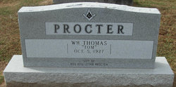
William Thomas “Tom” Procter
| Birth | : | 5 Oct 1927 Enon, Moniteau County, Missouri, USA |
| Death | : | 3 Jun 2012 Tuscumbia, Miller County, Missouri, USA |
| Burial | : | Olean Cemetery, Olean, Miller County, USA |
| Coordinate | : | 38.4131012, -92.5413971 |
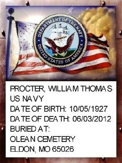
| Description | : | Tom Procter, age 84, of Eldon, passed away Sunday evening, June 3, 2012, at the Miller County Nursing Home in Tuscumbia. He was born on October 5, 1927 in Enon, Missouri the son of the late Roy and Letha (Lehr) Procter. Tom served in the United States Navy. He was a member of the First Christian Church of Eldon, and the Masonic Lodge of the Free Mason. He served as the Mayor of Eldon from 1978 to 1982. Tom was an avid fisherman, hunter and he loved to golf. Visitation will be held on Wednesday, June 6, 2012, from 3:00... Read More |
frequently asked questions (FAQ):
-
Where is William Thomas “Tom” Procter's memorial?
William Thomas “Tom” Procter's memorial is located at: Olean Cemetery, Olean, Miller County, USA.
-
When did William Thomas “Tom” Procter death?
William Thomas “Tom” Procter death on 3 Jun 2012 in Tuscumbia, Miller County, Missouri, USA
-
Where are the coordinates of the William Thomas “Tom” Procter's memorial?
Latitude: 38.4131012
Longitude: -92.5413971
Family Members:
Parent

Siblings
Flowers:


Nearby Cemetories:
1. Olean Cemetery
Olean, Miller County, USA
Coordinate: 38.4131012, -92.5413971
2. Green Ridge Baptist Church Cemetery
Eldon, Miller County, USA
Coordinate: 38.4116200, -92.5645700
3. Etter-Walker Cemetery
Burris Fork, Moniteau County, USA
Coordinate: 38.4333700, -92.5525400
4. Walker Cemetery
Moniteau County, USA
Coordinate: 38.4338989, -92.5522003
5. Farris Cemetery
Moniteau County, USA
Coordinate: 38.4369900, -92.5380000
6. Allen Cemetery
Olean, Miller County, USA
Coordinate: 38.4150009, -92.5008011
7. Jackson Chapel Methodist Church Cemetery
California, Moniteau County, USA
Coordinate: 38.4447900, -92.5286500
8. Gray Cemetery
Moniteau County, USA
Coordinate: 38.4536018, -92.5456009
9. Hite Cemetery
Miller County, USA
Coordinate: 38.4039001, -92.5935974
10. Mount Pleasant Cemetery
Eldon, Miller County, USA
Coordinate: 38.3667700, -92.5300800
11. Salem Cemetery
Saline Township, Miller County, USA
Coordinate: 38.3691232, -92.5697260
12. Salem Cemetery
Eldon, Miller County, USA
Coordinate: 38.3697014, -92.5714035
13. Mount Vernon Cemetery
Eldon, Miller County, USA
Coordinate: 38.3624992, -92.5606003
14. Bruce-Lewis-McGahan Cemetery
Enon, Moniteau County, USA
Coordinate: 38.4667500, -92.5172100
15. Rock Enon Cemetery
Miller County, USA
Coordinate: 38.4668400, -92.5170700
16. Eldon Cemetery
Eldon, Miller County, USA
Coordinate: 38.3642006, -92.5868988
17. Phillips Cemetery
High Point, Moniteau County, USA
Coordinate: 38.4430300, -92.6125300
18. Colburn Cemetery
Eldon, Miller County, USA
Coordinate: 38.4246300, -92.6275500
19. Depp Cemetery
High Point, Moniteau County, USA
Coordinate: 38.4776400, -92.5818500
20. High Point Cemetery
High Point, Moniteau County, USA
Coordinate: 38.4817009, -92.5757980
21. Phillips Cemetery
Barnett, Morgan County, USA
Coordinate: 38.4227982, -92.6367035
22. Matheis Cemetery
Russellville, Cole County, USA
Coordinate: 38.4571800, -92.4491600
23. United Baptist Church Cemetery
High Point, Moniteau County, USA
Coordinate: 38.4962200, -92.5856800
24. Karnes-Carney-Henderson Cemetery
Burris Fork, Moniteau County, USA
Coordinate: 38.4992100, -92.5007510