


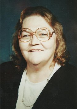
Willis Albert “Bill” Boley Sr.
| Birth | : | 15 Nov 1908 Maxville, Perry County, Ohio, USA |
| Death | : | 8 Jan 1989 Columbus, Franklin County, Ohio, USA |
| Burial | : | Pleasantview Cemetery, Tecumseh, Vigo County, USA |
| Coordinate | : | 39.5611000, -87.4255981 |
| Plot | : | Section L Lot 211 |
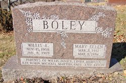
| Inscription | : | Parents of Willis, Janice, Linda, Marilyn, Kay, Robin, Michael, Martha, Paul, Kevin |
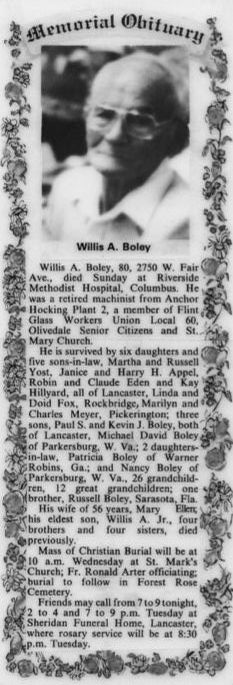
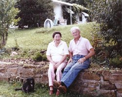
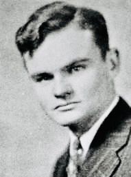
| Description | : | Bill Boley was in the Lancaster High School Class of 1929 on Mulberry St. He was a LHS football player and they called him, "Big Bill" Boley. He was born at 5303 Dutch Ridge Rd., Maxville, Ohio. Bill was interviewed by his daughter Linda & husband in the 1980s about his upbringing. He said, when he was a boy, his family moved from Perry Co. to a farm in Hooker near Lancaster abt 1916. His Dad & the boys drove the livestock up on foot through the town of Lancaster. His Mom, sisters & the furniture... Read More |
frequently asked questions (FAQ):
-
Where is Willis Albert “Bill” Boley Sr.'s memorial?
Willis Albert “Bill” Boley Sr.'s memorial is located at: Pleasantview Cemetery, Tecumseh, Vigo County, USA.
-
When did Willis Albert “Bill” Boley Sr. death?
Willis Albert “Bill” Boley Sr. death on 8 Jan 1989 in Columbus, Franklin County, Ohio, USA
-
Where are the coordinates of the Willis Albert “Bill” Boley Sr.'s memorial?
Latitude: 39.5611000
Longitude: -87.4255981
Family Members:
Parent

Spouse
Siblings

Children


Flowers:


Nearby Cemetories:
1. Pleasantview Cemetery
Tecumseh, Vigo County, USA
Coordinate: 39.5611000, -87.4255981
2. Hay Cemetery
Tecumseh, Vigo County, USA
Coordinate: 39.5541250, -87.4319730
3. Barbour Cemetery
New Goshen, Vigo County, USA
Coordinate: 39.5710983, -87.4507980
4. Coal Creek Cemetery
Vigo County, USA
Coordinate: 39.5353250, -87.4246580
5. Shepherds Cemetery
Shepardsville, Vigo County, USA
Coordinate: 39.5959015, -87.4181976
6. Lyons Cemetery
North Terre Haute, Vigo County, USA
Coordinate: 39.5719380, -87.3815960
7. Webster Burying Ground
Terre Haute, Vigo County, USA
Coordinate: 39.5788190, -87.3796730
8. Roselawn Memorial Park
Terre Haute, Vigo County, USA
Coordinate: 39.5559998, -87.3720016
9. Brick Church Cemetery
New Goshen, Vigo County, USA
Coordinate: 39.5932000, -87.4623000
10. Denny Cemetery
North Terre Haute, Vigo County, USA
Coordinate: 39.5425770, -87.3740100
11. Chunn Cemetery
Clinton Township, Vermillion County, USA
Coordinate: 39.6075770, -87.4366350
12. Otter Creek Union Cemetery
North Terre Haute, Vigo County, USA
Coordinate: 39.5347977, -87.3723907
13. Haymaker Cemetery
New Goshen, Vigo County, USA
Coordinate: 39.5658000, -87.4890700
14. Bethel Cemetery
Saint Mary-of-the-Woods, Vigo County, USA
Coordinate: 39.5203438, -87.4653320
15. New Vermillion Cemetery
Sandford, Vigo County, USA
Coordinate: 39.5414009, -87.4871979
16. Fort Harrison Cemetery
Terre Haute, Vigo County, USA
Coordinate: 39.5084200, -87.4125370
17. Sisters of Providence Cemetery
Saint Mary-of-the-Woods, Vigo County, USA
Coordinate: 39.5094830, -87.4566440
18. Providence Community Cemetery
Saint Mary-of-the-Woods, Vigo County, USA
Coordinate: 39.5093200, -87.4576100
19. Carson Cemetery
Sandford, Vigo County, USA
Coordinate: 39.5599022, -87.5004044
20. Church of the Immaculate Conception
Saint Mary-of-the-Woods, Vigo County, USA
Coordinate: 39.5096030, -87.4601840
21. Wood Cemetery
North Terre Haute, Vigo County, USA
Coordinate: 39.5872002, -87.3581009
22. Stevenson Cemetery
North Terre Haute, Vigo County, USA
Coordinate: 39.5713997, -87.3510971
23. Balding Cemetery
North Terre Haute, Vigo County, USA
Coordinate: 39.5463000, -87.3521000
24. Saint Marys Village Church Cemetery
Saint Mary-of-the-Woods, Vigo County, USA
Coordinate: 39.5127300, -87.4696100