
| Memorials | : | 0 |
| Location | : | Natural Dam, Crawford County, USA |
| Coordinate | : | 35.7265854, -94.3815689 |
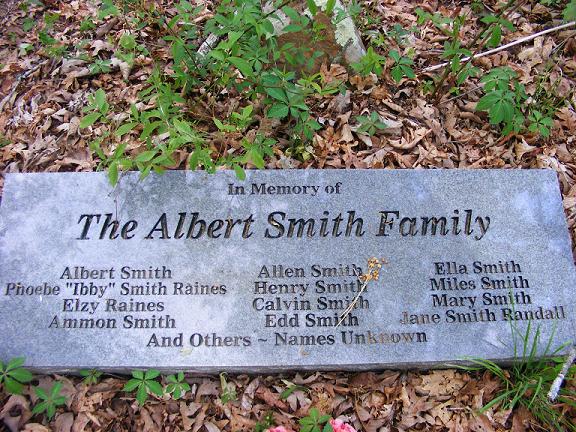
| Description | : | This cemetery is located 1-3 miles from the Bridge, about 100 yards off of Cove Creek Crossing to the North. The sign "Smith Cemetery" is just next to the road. There is a slightly visible trail back into the woods about 100 yards or so to the cemetery. A barbed wire fence has been stretched around the cemetery. There are SEVERAL Rocks sticking up all around, which I'm sure are markings for graves. The "Smith Family Cemetery" photo is very visible and in the middle of the fenced area. There is also a stone... Read More |
frequently asked questions (FAQ):
-
Where is Albert Smith Cemetery?
Albert Smith Cemetery is located at Cove Creek Crossing Natural Dam, Crawford County ,Arkansas ,USA.
-
Albert Smith Cemetery cemetery's updated grave count on graveviews.com?
0 memorials
-
Where are the coordinates of the Albert Smith Cemetery?
Latitude: 35.7265854
Longitude: -94.3815689

Nearby Cemetories:
1. Deason Cemetery
Crawford County, USA
Coordinate: 35.7314550, -94.4073630
2. Clawson Cemetery
Natural Dam, Crawford County, USA
Coordinate: 35.7315690, -94.4075350
3. Barker Cemetery
Crawford County, USA
Coordinate: 35.7391100, -94.4035490
4. Garrett Creek Cemetery
Washington County, USA
Coordinate: 35.7710991, -94.3792038
5. Leach Cemetery
Crawford County, USA
Coordinate: 35.7498820, -94.4308270
6. Liberty Hill Cemetery
Crawford County, USA
Coordinate: 35.7362595, -94.4383774
7. Dobbs Cemetery
Washington County, USA
Coordinate: 35.7641983, -94.4210968
8. Oak Grove Cemetery
Crawford County, USA
Coordinate: 35.7504005, -94.3262787
9. Bryant Cemetery
Cove City, Crawford County, USA
Coordinate: 35.7022018, -94.3178024
10. Bugscuffle Cemetery
Strickler, Washington County, USA
Coordinate: 35.7841500, -94.3419460
11. Clanton Cemetery
Floss, Washington County, USA
Coordinate: 35.7935110, -94.3619370
12. Hall Cemetery
Natural Dam, Crawford County, USA
Coordinate: 35.6577988, -94.3981018
13. Dunkard Cemetery
Strickler, Washington County, USA
Coordinate: 35.7775002, -94.3217010
14. Shamrock Cemetery
Cedarville, Crawford County, USA
Coordinate: 35.6611099, -94.3460464
15. Camp Meeting Cemetery
Lee Creek, Crawford County, USA
Coordinate: 35.7284000, -94.2894000
16. Kimbler Cemetery
Cove City, Crawford County, USA
Coordinate: 35.6506004, -94.3506012
17. Bateman Cemetery
Crawford County, USA
Coordinate: 35.7158012, -94.4824982
18. Antioch Cemetery
Morrow, Washington County, USA
Coordinate: 35.8129760, -94.4075990
19. Mountain Top Cemetery
Evansville, Washington County, USA
Coordinate: 35.7693030, -94.4798000
20. Liberty 86 Cemetery
Strickler, Washington County, USA
Coordinate: 35.7844009, -94.2910995
21. Dunagan Cemetery
Evansville, Washington County, USA
Coordinate: 35.8025017, -94.4499969
22. English Cemetery
Strickler, Washington County, USA
Coordinate: 35.7970000, -94.3015770
23. Goddard Cemetery
Washington County, USA
Coordinate: 35.7985992, -94.4636002
24. Willett Family Cemetery
Morrow, Washington County, USA
Coordinate: 35.8231550, -94.4098840