
| Memorials | : | 0 |
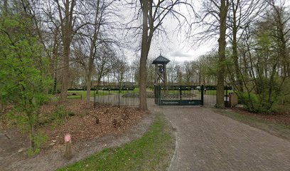
| Location | : | Creil, Noordoostpolder Municipality, Netherlands |
| Coordinate | : | 52.7629574, 5.6640223 |
frequently asked questions (FAQ):
-
Where is Algemene bregraafplaats?
Algemene bregraafplaats is located at Graaf Florislaan Creil, Noordoostpolder Municipality ,Flevoland ,Netherlands.
-
Algemene bregraafplaats cemetery's updated grave count on graveviews.com?
0 memorials
-
Where are the coordinates of the Algemene bregraafplaats?
Latitude: 52.7629574
Longitude: 5.6640223
Nearby Cemetories:
1. Algemene Begraafplaats
Espel, Noordoostpolder Municipality, Netherlands
Coordinate: 52.7174188, 5.6432473
2. Emmeloord General Cemetery
Emmeloord, Noordoostpolder Municipality, Netherlands
Coordinate: 52.7167200, 5.7453700
3. Lemmer General Cemetery
Lemmer, De Fryske Marren Municipality, Netherlands
Coordinate: 52.8479500, 5.7133100
4. Vormtweg 11
Urk, Urk Municipality, Netherlands
Coordinate: 52.6722645, 5.6091134
5. Joodse Begraafplaats Tacozijl
Lemmer, De Fryske Marren Municipality, Netherlands
Coordinate: 52.8630740, 5.6452610
6. Oude Begraafplaats Kerkje aan de Zee
Urk, Urk Municipality, Netherlands
Coordinate: 52.6621322, 5.5935175
7. Nijemirdum General Cemetery
Nijemirdum, De Fryske Marren Municipality, Netherlands
Coordinate: 52.8557700, 5.5669600
8. Kuinre General Cemetery
Kuinre, Steenwijkerland Municipality, Netherlands
Coordinate: 52.7954100, 5.8393400
9. Algemene begraafplaats
Luttelgeest, Noordoostpolder Municipality, Netherlands
Coordinate: 52.7479507, 5.8546040
10. Kerkhof Oudemirdum
Oudemirdum, De Fryske Marren Municipality, Netherlands
Coordinate: 52.8498364, 5.5332713
11. Natuurbegraafplaats Bremer Wildernis
Sondel, De Fryske Marren Municipality, Netherlands
Coordinate: 52.8714341, 5.5754786
12. Kerkhof NH Vaste Burchtker
Wijckel, De Fryske Marren Municipality, Netherlands
Coordinate: 52.8889630, 5.6246630
13. Bakhuizen Roman Catholic Cemetery
Bakhuizen, De Fryske Marren Municipality, Netherlands
Coordinate: 52.8692200, 5.4557500
14. Ijpecolsga General Cemetery
IJpecolsga, Sudwest Fryslan Municipality, Netherlands
Coordinate: 52.9344500, 5.6072800
15. Joodse Begraafplaats
Blokzijl, Steenwijkerland Municipality, Netherlands
Coordinate: 52.7253110, 5.9623440
16. Blokzijl General Cemetery
Blokzijl, Steenwijkerland Municipality, Netherlands
Coordinate: 52.7253900, 5.9624600
17. Oldetrijne Cemetery
Oldetrijne, Weststellingwerf Municipality, Netherlands
Coordinate: 52.8566500, 5.9318600
18. Stad-Vollenhove General Cemetery
Vollenhove, Steenwijkerland Municipality, Netherlands
Coordinate: 52.6808200, 5.9459100
19. Scharl General Cemetery
Skarl, Sudwest Fryslan Municipality, Netherlands
Coordinate: 52.8672300, 5.3909200
20. Koudum General Cemetery
Koudum, Sudwest Fryslan Municipality, Netherlands
Coordinate: 52.9114400, 5.4456200
21. Molkwerum Protestant Churchyard
Molkwerum, Sudwest Fryslan Municipality, Netherlands
Coordinate: 52.9001600, 5.3992000
22. Algemene Begraafplaats
Paasloo, Steenwijkerland Municipality, Netherlands
Coordinate: 52.8133500, 6.0135300
23. Westermeer Begraafplaats
Joure, De Fryske Marren Municipality, Netherlands
Coordinate: 52.9634300, 5.8033480
24. Staveren General Cemetery
Stavoren, Sudwest Fryslan Municipality, Netherlands
Coordinate: 52.8820900, 5.3600500