
| Memorials | : | 14 |
| Location | : | Creeksea, Maldon District, England |
| Coordinate | : | 51.6376640, 0.7882050 |
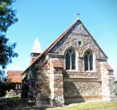
| Description | : | Creeksea is a village in Essex, UK, on the Dengie peninsula on the north side of the River Crouch, one mile west of Burnham on Crouch. It is part of the Maldon district. Many variations of the name are found in old documents including Cricksea , Crykseye and Crixsey. All Saints Church is the Parish Church of the Parish of Creeksea., a very rural Parish. Very few houses remain within the Parish boundaries and the congregation is drawn principally from people living in Burnham. The Church building is relatively remote and is approached via a private drive off Ferry... Read More |
frequently asked questions (FAQ):
-
Where is All Saints Churchyard?
All Saints Churchyard is located at Creeksea Lane Creeksea, Maldon District ,Essex , CM0 8PQEngland.
-
All Saints Churchyard cemetery's updated grave count on graveviews.com?
14 memorials
-
Where are the coordinates of the All Saints Churchyard?
Latitude: 51.6376640
Longitude: 0.7882050
Nearby Cemetories:
1. St. Mary the Virgin Churchyard
Burnham-on-Crouch, Maldon District, England
Coordinate: 51.6383030, 0.8147260
2. Burnham-on-Crouch Cemetery
Burnham-on-Crouch, Maldon District, England
Coordinate: 51.6448720, 0.8146910
3. Crouch Valley Meadow
Althorne, Maldon District, England
Coordinate: 51.6538315, 0.7552450
4. St Andrew Churchyard
Althorne, Maldon District, England
Coordinate: 51.6566690, 0.7585130
5. St Barnabas Churchyard
Mayland, Maldon District, England
Coordinate: 51.6679410, 0.7817620
6. St. Peter's Churchyard
Paglesham, Rochford District, England
Coordinate: 51.6034280, 0.7799570
7. St Leonard Churchyard
Southminster, Maldon District, England
Coordinate: 51.6619130, 0.8303250
8. St Nicholas Churchyard
Canewdon, Rochford District, England
Coordinate: 51.6177030, 0.7383670
9. Saint Michaels Churchyard
Latchingdon, Maldon District, England
Coordinate: 51.6552730, 0.7267950
10. St. Lawrence and All Saints Churchyard
Steeple, Maldon District, England
Coordinate: 51.6921890, 0.7977453
11. St Laurence Churchyard
Asheldham, Maldon District, England
Coordinate: 51.6753830, 0.8606240
12. St Mary Churchyard
Stambridge, Rochford District, England
Coordinate: 51.5948750, 0.7233380
13. Thornton Meadows Wildflower Cemetery
Ashingdon, Rochford District, England
Coordinate: 51.6131670, 0.6983290
14. All Saints Churchyard
South Fambridge, Rochford District, England
Coordinate: 51.6232020, 0.6879920
15. St Mary and All Saints Churchyard
Stambridge, Rochford District, England
Coordinate: 51.5835790, 0.7331670
16. All Saints Churchyard
Barling Magna, Rochford District, England
Coordinate: 51.5729840, 0.7865930
17. St Andrew Churchyard
Ashingdon, Rochford District, England
Coordinate: 51.6103050, 0.6933730
18. St. James Churchyard
Dengie, Maldon District, England
Coordinate: 51.6779940, 0.8759400
19. St. Mary's Churchyard
Mundon, Maldon District, England
Coordinate: 51.6911950, 0.7182714
20. St. James Graveyard Extension
Dengie, Maldon District, England
Coordinate: 51.6775585, 0.8812442
21. Holy Trinity Churchyard
North Fambridge, Maldon District, England
Coordinate: 51.6425440, 0.6721570
22. St Lawrence Churchyard
St Lawrence, Maldon District, England
Coordinate: 51.7032040, 0.8451860
23. St. Stephen's Churchyard
Cold Norton, Maldon District, England
Coordinate: 51.6670870, 0.6764950
24. St Mary the Virgin Churchyard
Little Wakering, Southend-on-Sea Unitary Authority, England
Coordinate: 51.5606390, 0.7894770