
| Memorials | : | 0 |
| Location | : | South Fambridge, Rochford District, England |
| Coordinate | : | 51.6232020, 0.6879920 |
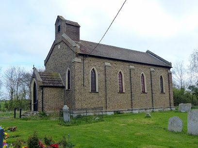
| Description | : | South Fambridge is a rural parish in South East Essex, some 48 miles east of the centre of London, and 3 miles from Rochford. It is one of two Fambridge parishes, the other being North Fambridge across the other side of the tidal River Crouch. It is reached by a quiet lane from Ashingdon. Until the early 20th century it was connected by ferry with the larger North Fambridge on the North side of the river. South Fambridge was the location for the first British airfield (1909). The small church, dedicated to All Saints, can be found in Fambridge Road, off... Read More |
frequently asked questions (FAQ):
-
Where is All Saints Churchyard?
All Saints Churchyard is located at South Fambridge, Rochford District ,Essex ,England.
-
All Saints Churchyard cemetery's updated grave count on graveviews.com?
0 memorials
-
Where are the coordinates of the All Saints Churchyard?
Latitude: 51.6232020
Longitude: 0.6879920
Nearby Cemetories:
1. Thornton Meadows Wildflower Cemetery
Ashingdon, Rochford District, England
Coordinate: 51.6131670, 0.6983290
2. St Andrew Churchyard
Ashingdon, Rochford District, England
Coordinate: 51.6103050, 0.6933730
3. Holy Trinity Churchyard
North Fambridge, Maldon District, England
Coordinate: 51.6425440, 0.6721570
4. St Nicholas Churchyard
Canewdon, Rochford District, England
Coordinate: 51.6177030, 0.7383670
5. St Peter and St Paul Churchyard
Hockley, Rochford District, England
Coordinate: 51.6098370, 0.6356820
6. St Mary Churchyard
Stambridge, Rochford District, England
Coordinate: 51.5948750, 0.7233380
7. Hall Road Cemetery
Rochford, Rochford District, England
Coordinate: 51.5842870, 0.6749670
8. Saint Michaels Churchyard
Latchingdon, Maldon District, England
Coordinate: 51.6552730, 0.7267950
9. Rochford Lawn Cemetery
Rochford, Rochford District, England
Coordinate: 51.5829870, 0.6759490
10. St. Andrew's Churchyard
Rochford, Rochford District, England
Coordinate: 51.5803090, 0.7002030
11. St. Stephen's Churchyard
Cold Norton, Maldon District, England
Coordinate: 51.6670870, 0.6764950
12. Ss. Mary and Margaret Churchyard
Stow Maries, Maldon District, England
Coordinate: 51.6633220, 0.6498190
13. St Mary and All Saints Churchyard
Stambridge, Rochford District, England
Coordinate: 51.5835790, 0.7331670
14. Crouch Valley Meadow
Althorne, Maldon District, England
Coordinate: 51.6538315, 0.7552450
15. Rochford District Council Cemetery
Rayleigh, Rochford District, England
Coordinate: 51.5936500, 0.6135600
16. St Andrew Churchyard
Althorne, Maldon District, England
Coordinate: 51.6566690, 0.7585130
17. St Laurence and All Saints Churchyard
Eastwood, Southend-on-Sea Unitary Authority, England
Coordinate: 51.5677030, 0.6847360
18. All Saints Churchyard
Sutton, Rochford District, England
Coordinate: 51.5703210, 0.7226620
19. St. Peter's Churchyard
Paglesham, Rochford District, England
Coordinate: 51.6034280, 0.7799570
20. Holy Trinity Churchyard
Rayleigh, Rochford District, England
Coordinate: 51.5879958, 0.6085753
21. All Saints Churchyard
Creeksea, Maldon District, England
Coordinate: 51.6376640, 0.7882050
22. All Saints Churchyard
Purleigh, Maldon District, England
Coordinate: 51.6868780, 0.6624630
23. Stock Road Jewish Cemetery
Southend-on-Sea, Southend-on-Sea Unitary Authority, England
Coordinate: 51.5571444, 0.7055500
24. Sutton Road Cemetery
Southend-on-Sea, Southend-on-Sea Unitary Authority, England
Coordinate: 51.5581980, 0.7160330