
| Memorials | : | 7 |
| Location | : | Iwade, Swale Borough, England |
| Coordinate | : | 51.3787920, 0.7306550 |
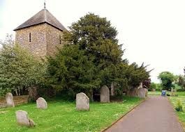
| Description | : | Iwade is a small village on the north side of Detling Hill, close to the town of Sittingbourne in Kent, England, having quick access to the M2 & M20 motorways, as well as within a short driving distance to Maidstone, and further Canterbury & Faversham. Surrounded by countryside, overlooking The Swale and on to the Isle of Sheppey, it is currently being developed with luxury housing and small retail units, centered around the original Kentish village and historic 'All Saints' Church. The village is characterized by green spaces and the local architectural style. It is widely said that the village got its... Read More |
frequently asked questions (FAQ):
-
Where is All Saints Churchyard?
All Saints Churchyard is located at The Street Iwade, Swale Borough ,Kent , ME9 8SJEngland.
-
All Saints Churchyard cemetery's updated grave count on graveviews.com?
7 memorials
-
Where are the coordinates of the All Saints Churchyard?
Latitude: 51.3787920
Longitude: 0.7306550
Nearby Cemetories:
1. Garden of England Crematorium
Bobbing, Swale Borough, England
Coordinate: 51.3595330, 0.7179190
2. Holy Trinity Churchyard
Milton Regis, Swale Borough, England
Coordinate: 51.3556700, 0.7401300
3. St. Bartholomew's Churchyard
Bobbing, Swale Borough, England
Coordinate: 51.3537600, 0.7101420
4. Holy Trinity Church
Sittingbourne, Swale Borough, England
Coordinate: 51.3416000, 0.7316000
5. St Margaret of Antioch Churchyard
Lower Halstow, Swale Borough, England
Coordinate: 51.3752975, 0.6711660
6. Murston Cemetery
Sittingbourne, Swale Borough, England
Coordinate: 51.3424700, 0.7527100
7. Holy Trinity Churchyard
Queenborough, Swale Borough, England
Coordinate: 51.4174080, 0.7443560
8. St Mary the Virgin Churchyard
Newington, Swale Borough, England
Coordinate: 51.3567080, 0.6733120
9. Sittingbourne Cemetery
Sittingbourne, Swale Borough, England
Coordinate: 51.3345300, 0.7348000
10. St Giles Churchyard
Tonge, Swale Borough, England
Coordinate: 51.3424640, 0.7757790
11. St Peter and St Paul Churchyard
Borden, Swale Borough, England
Coordinate: 51.3347350, 0.7008350
12. St. Laurence's Churchyard
Bapchild, Swale Borough, England
Coordinate: 51.3330520, 0.7655020
13. Sheppey Cemetery
Sheerness, Swale Borough, England
Coordinate: 51.4232780, 0.7718320
14. St Mary the Virgin Churchyard
Upchurch, Swale Borough, England
Coordinate: 51.3764687, 0.6476030
15. St John the Baptist Churchyard
Tunstall, Swale Borough, England
Coordinate: 51.3246010, 0.7196400
16. St. Nicholas Churchyard
Rodmersham, Swale Borough, England
Coordinate: 51.3227780, 0.7627730
17. St. Michael and All Angels Churchyard
Hartlip, Swale Borough, England
Coordinate: 51.3478310, 0.6396320
18. Minster Abbey
Minster on Sea, Swale Borough, England
Coordinate: 51.4219320, 0.8119580
19. Ss Mary and Sexburga New Churchyard
Minster on Sea, Swale Borough, England
Coordinate: 51.4235540, 0.8098720
20. St Mary Churchyard
Teynham, Swale Borough, England
Coordinate: 51.3377640, 0.8213570
21. St. John the Baptist Churchyard
Bredgar, Swale Borough, England
Coordinate: 51.3109210, 0.6960930
22. St Peter and St Paul New Churchyard
Lynsted, Swale Borough, England
Coordinate: 51.3150770, 0.7864080
23. St Peter and St Paul Churchyard
Lynsted, Swale Borough, England
Coordinate: 51.3138300, 0.7860890
24. Saint Mary Magdalene Churchyard
Stockbury, Maidstone Borough, England
Coordinate: 51.3247700, 0.6488800