
| Memorials | : | 54 |
| Location | : | South Norfolk District, England |
| Website | : | www.exploringnorfolkchurches.org/church/all-saints-welborne/ |
| Coordinate | : | 52.6496860, 1.0546670 |
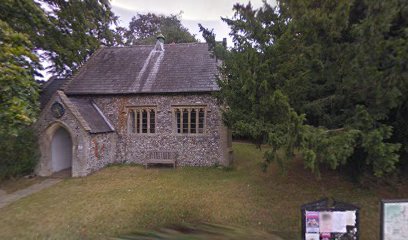
| Description | : | All Saints' Church at Welborne is a delightful little church set within a grassed area and flanked by low hanging trees. The original nave building is likely to be one of the earliest parts of the church, possibly dating to the early Norman period. The round tower, curiously blind except for a small window at head height, dates to the 15th century and like the rest of the building is largely of flint. The church was remodelled around 1280, gaining a chancel building which survived until the Victorian restoration of 1874. During the 14th century the nave was altered, and remodelled... Read More |
frequently asked questions (FAQ):
-
Where is All Saints, Welborne?
All Saints, Welborne is located at Church Lane / Hill Lane Welborne, South Norfolk District ,Norfolk , NR20 3LQEngland.
-
All Saints, Welborne cemetery's updated grave count on graveviews.com?
53 memorials
-
Where are the coordinates of the All Saints, Welborne?
Latitude: 52.6496860
Longitude: 1.0546670
Nearby Cemetories:
1. All Saints Churchyard
Mattishall, Breckland Borough, England
Coordinate: 52.6498440, 1.0551390
2. All Saints' Churchyard
Mattishall, Breckland Borough, England
Coordinate: 52.6580670, 1.0346230
3. Mattishall cemetery
Mattishall, Breckland Borough, England
Coordinate: 52.6597100, 1.0353800
4. St Peter's Church Mattishall Burgh
Mattishall, Breckland Borough, England
Coordinate: 52.6647174, 1.0396513
5. All Saints Churchyard
East Tuddenham, Breckland Borough, England
Coordinate: 52.6602410, 1.0813620
6. St. Peter and St. Paul Churchyard
Barnham Broom, South Norfolk District, England
Coordinate: 52.6281830, 1.0749820
7. St. Mary's Churchyard
North Tuddenham, Breckland Borough, England
Coordinate: 52.6753000, 1.0389600
8. St. Michael's Churchyard
Hockering, Breckland Borough, England
Coordinate: 52.6771691, 1.0629078
9. All Saints Churchyard
Runhall, South Norfolk District, England
Coordinate: 52.6209876, 1.0390341
10. St. Andrew's Churchyard
Colton, South Norfolk District, England
Coordinate: 52.6407700, 1.1089300
11. St Botolphs
Barford, South Norfolk District, England
Coordinate: 52.6287000, 1.1118000
12. St Paul's Church Thuxton
Dereham, Breckland Borough, England
Coordinate: 52.6239060, 1.0013630
13. St Andrew's Churchyard
Honingham, Broadland District, England
Coordinate: 52.6573170, 1.1244600
14. St Mary's Churchyard
Carleton Forehoe, South Norfolk District, England
Coordinate: 52.6100400, 1.0847490
15. St. Margaret's Churchyard
Garvestone, Breckland Borough, England
Coordinate: 52.6264200, 0.9889550
16. St. George's Churchyard
Hardingham, Breckland Borough, England
Coordinate: 52.6058090, 1.0040050
17. St. Peter's Churchyard
Kimberley, South Norfolk District, England
Coordinate: 52.5958100, 1.0572070
18. St. Mary's Churchyard
Marlingford, South Norfolk District, England
Coordinate: 52.6310660, 1.1416800
19. St. Peter's Churchyard
Reymerston, Breckland Borough, England
Coordinate: 52.6144500, 0.9827500
20. St. Peter's Churchyard
Easton, South Norfolk District, England
Coordinate: 52.6543660, 1.1478070
21. Saint Mary the Virgin Churchyard
Elsing, Breckland Borough, England
Coordinate: 52.7076070, 1.0354460
22. All Saints Churchyard
Weston Longville, Broadland District, England
Coordinate: 52.6990630, 1.1257670
23. All Saints Churchyard
Weston Longville, Broadland District, England
Coordinate: 52.6993460, 1.1262510
24. Lyng, St. Margaret.
Lyng, Breckland Borough, England
Coordinate: 52.7185190, 1.0619570