
| Memorials | : | 0 |
| Location | : | Snodland, Tonbridge and Malling Borough, England |
| Coordinate | : | 51.3246110, 0.4406010 |
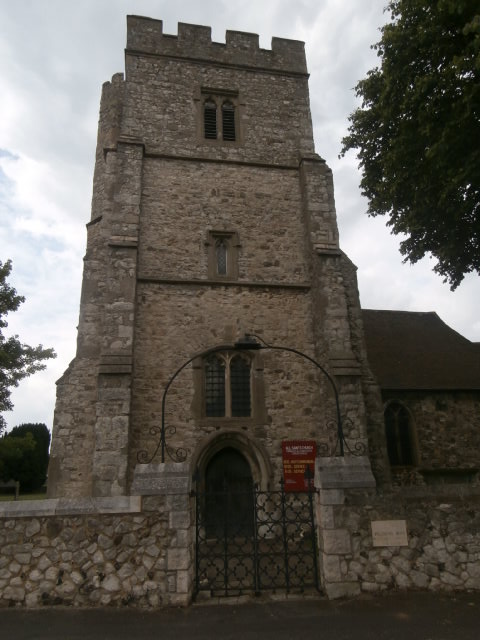
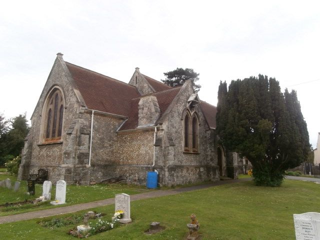
| Description | : | Christ Church, also known as Snodland, Christ Church and as Lower Birling, All Saints with Christchurch is part of the united benefice of All Saints Snodland with Christ Church Lower Birling. Lower Birling is now effectively part of Snodland. The church stands on the Malling Road opposite St. Katherine's Lane. It is one of two functioning Anglican churches in Snodland. All Saints is in Mill Street close to the River Medway, opposite the paper mill and almost next to the railway station. Built in 1892, burials recorded from 1894. |
frequently asked questions (FAQ):
-
Where is All Saints with Christchurch Churchyard?
All Saints with Christchurch Churchyard is located at Junction of St. Katherine's Lane with Malling Road Snodland, Tonbridge and Malling Borough ,Kent , ME6 5EEEngland.
-
All Saints with Christchurch Churchyard cemetery's updated grave count on graveviews.com?
0 memorials
-
Where are the coordinates of the All Saints with Christchurch Churchyard?
Latitude: 51.3246110
Longitude: 0.4406010
Nearby Cemetories:
1. All Saints Churchyard
Snodland, Tonbridge and Malling Borough, England
Coordinate: 51.3299000, 0.4496900
2. Snodland Cemetery
Snodland, Tonbridge and Malling Borough, England
Coordinate: 51.3336110, 0.4348770
3. St Mary Old Churchyard
Burham, Tonbridge and Malling Borough, England
Coordinate: 51.3312262, 0.4619326
4. St. Benedict Churchyard
Snodland, Tonbridge and Malling Borough, England
Coordinate: 51.3332200, 0.4171600
5. Holy Trinity Churchyard
Larkfield, Tonbridge and Malling Borough, England
Coordinate: 51.3062210, 0.4441090
6. All Saints Churchyard
Birling, Tonbridge and Malling Borough, England
Coordinate: 51.3197010, 0.4097520
7. St Peter and St Paul Churchyard
Leybourne, Tonbridge and Malling Borough, England
Coordinate: 51.3042520, 0.4222550
8. St John the Baptist Churchyard
Halling, Medway Unitary Authority, England
Coordinate: 51.3484993, 0.4468510
9. Eccles War Memorial
Aylesford, Tonbridge and Malling Borough, England
Coordinate: 51.3178120, 0.4788630
10. Burham War Memorial
Burham, Tonbridge and Malling Borough, England
Coordinate: 51.3327530, 0.4785610
11. Halling Church Cemetery
Halling, Medway Unitary Authority, England
Coordinate: 51.3499140, 0.4447960
12. Halling War Memorial
Halling, Medway Unitary Authority, England
Coordinate: 51.3519630, 0.4439060
13. Aylesford Priory
Aylesford, Tonbridge and Malling Borough, England
Coordinate: 51.3030586, 0.4724390
14. St Peter ad vincula Churchyard
Ditton, Tonbridge and Malling Borough, England
Coordinate: 51.2958810, 0.4510820
15. All Saints Churchyard
Wouldham, Tonbridge and Malling Borough, England
Coordinate: 51.3528130, 0.4580580
16. St Peter and St Paul Churchyard
Aylesford, Tonbridge and Malling Borough, England
Coordinate: 51.3040630, 0.4793870
17. Aylesford Cemetery
Aylesford, Tonbridge and Malling Borough, England
Coordinate: 51.3001000, 0.4752090
18. Royal British Legion Village Memorial
Aylesford, Tonbridge and Malling Borough, England
Coordinate: 51.2964380, 0.4744810
19. St. James the Great Churchyard
East Malling, Tonbridge and Malling Borough, England
Coordinate: 51.2874670, 0.4402040
20. St. Mary the Virgin Churchyard
West Malling, Tonbridge and Malling Borough, England
Coordinate: 51.2921700, 0.4068400
21. Medway Crematorium
Chatham, Medway Unitary Authority, England
Coordinate: 51.3331340, 0.5107590
22. St Michael Churchyard
Offham, Tonbridge and Malling Borough, England
Coordinate: 51.2974968, 0.3801070
23. St. Michael and All Angels Churchyard
Cuxton, Medway Unitary Authority, England
Coordinate: 51.3714120, 0.4546760
24. St Peter and St Paul Churchyard
Trottiscliffe, Tonbridge and Malling Borough, England
Coordinate: 51.3201520, 0.3612360