| Memorials | : | 126 |
| Location | : | Halling, Medway Unitary Authority, England |
| Coordinate | : | 51.3484993, 0.4468510 |
| Description | : | Halling is a mid sized village in a gap in the North Downs in the Northern part of Kent, England. Consisting of three parts, Lower Halling, Upper Halling and North Halling, the village is spread over 3 miles along the River Medway parallel to the Pilgrims' Way . On the A228 it is conveniently sited just 5 minutes drive from either the M20 or M2. |
frequently asked questions (FAQ):
-
Where is St John the Baptist Churchyard?
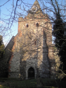
St John the Baptist Churchyard is located at High Street Halling, Medway Unitary Authority ,Kent ,England.
-
St John the Baptist Churchyard cemetery's updated grave count on graveviews.com?
125 memorials
-
Where are the coordinates of the St John the Baptist Churchyard?
Latitude: 51.3484993
Longitude: 0.4468510
Nearby Cemetories:
1. Halling Church Cemetery
Halling, Medway Unitary Authority, England
Coordinate: 51.3499140, 0.4447960
2. Halling War Memorial
Halling, Medway Unitary Authority, England
Coordinate: 51.3519630, 0.4439060
3. All Saints Churchyard
Wouldham, Tonbridge and Malling Borough, England
Coordinate: 51.3528130, 0.4580580
4. Snodland Cemetery
Snodland, Tonbridge and Malling Borough, England
Coordinate: 51.3336110, 0.4348770
5. All Saints Churchyard
Snodland, Tonbridge and Malling Borough, England
Coordinate: 51.3299000, 0.4496900
6. St Mary Old Churchyard
Burham, Tonbridge and Malling Borough, England
Coordinate: 51.3312262, 0.4619326
7. St. Michael and All Angels Churchyard
Cuxton, Medway Unitary Authority, England
Coordinate: 51.3714120, 0.4546760
8. St. Benedict Churchyard
Snodland, Tonbridge and Malling Borough, England
Coordinate: 51.3332200, 0.4171600
9. All Saints with Christchurch Churchyard
Snodland, Tonbridge and Malling Borough, England
Coordinate: 51.3246110, 0.4406010
10. Burham War Memorial
Burham, Tonbridge and Malling Borough, England
Coordinate: 51.3327530, 0.4785610
11. St Matthew Churchyard
Borstal, Medway Unitary Authority, England
Coordinate: 51.3736150, 0.4868020
12. Eccles War Memorial
Aylesford, Tonbridge and Malling Borough, England
Coordinate: 51.3178120, 0.4788630
13. All Saints Churchyard
Birling, Tonbridge and Malling Borough, England
Coordinate: 51.3197010, 0.4097520
14. St Peter and St Paul Churchyard
Luddesdown, Gravesham Borough, England
Coordinate: 51.3700218, 0.3974010
15. Holy Trinity Churchyard
Larkfield, Tonbridge and Malling Borough, England
Coordinate: 51.3062210, 0.4441090
16. Medway Crematorium
Chatham, Medway Unitary Authority, England
Coordinate: 51.3331340, 0.5107590
17. St. Margaret's Cemetery
Rochester, Medway Unitary Authority, England
Coordinate: 51.3777000, 0.5011600
18. St. Nicholas's Cemetery
Rochester, Medway Unitary Authority, England
Coordinate: 51.3780081, 0.5021076
19. St Peter and St Paul Churchyard
Leybourne, Tonbridge and Malling Borough, England
Coordinate: 51.3042520, 0.4222550
20. Strood Cemetery
Strood, Medway Unitary Authority, England
Coordinate: 51.3900220, 0.4838640
21. Aylesford Priory
Aylesford, Tonbridge and Malling Borough, England
Coordinate: 51.3030586, 0.4724390
22. St Peter and St Paul Churchyard
Aylesford, Tonbridge and Malling Borough, England
Coordinate: 51.3040630, 0.4793870
23. St Margaret Churchyard
Rochester, Medway Unitary Authority, England
Coordinate: 51.3849380, 0.4993630
24. Cobham War Memorial
Cobham, Gravesham Borough, England
Coordinate: 51.3900719, 0.4043670


